Romania's landscape is almost evenly divided among mountains (31 percent), hills (33 percent), and plains (36 percent). These varied relief forms spread rather symmetrically from the Carpathian Mountains, which reach elevations of more than 2,400 metres, to the Danube Delta, which is just a few metres above sea level.
The arc of the Carpathians extends over 1,000km through the center of the country, covering an area of 70,000 square km. These mountains are of low to medium altitude and are no wider than 100km. They are deeply fragmented by longitudinal and transverse valleys and crossed by several major rivers. These features and the fact that there are many summit passes—some at altitudes up to 2,256 metres—have made the Carpathians less of a barrier to movement than have other European ranges. Another distinguishing feature is the many eroded platforms that provide tableland at relatively high altitudes. There are permanent settlements here at above 1,200 metres.
Romania's Carpathians are differentiated into three ranges: the Eastern Carpathians, the Southern Carpathians or Transylvanian Alps, and the Western Carpathians. Each of these ranges has important distinguishing features. The Eastern Carpathians are composed of three parallel ridges that run from northwest to southeast. The westernmost ridge is an extinct volcanic range with many preserved cones and craters. The range has many large depressions, in the largest of which the city of Braşov is situated. Important mining and industrial centers as well as agricultural areas are found within these depressions. The Eastern Carpathians are covered with forests—some 32 percent of the country's woodlands are there. They also contain important ore deposits, including gold and silver, and their mineral water springs feed numerous health resorts.
The Southern Carpathians offer the highest peaks at Moldoveanu Peak (2,544 metres) and Negoiu (2,535 meters) and more than 150 glacial lakes. They have large grassland areas and some woodlands but few large depressions and subsoil resources. The region was crisscrossed by an ancient network of trans-Carpathian roads, and vestiges of the old Roman Way are still visible. Numerous passes and the valleys of the Olt, Jiu, and Danube rivers provide routes for roads and railways through the mountains.
The Western Carpathians are the lowest of the three ranges and are fragmented by many deep structural depressions. They have historically functioned as "gates," which allow easy passage but can be readily defended. The most famous of these is the Iron Gate on the Danube. The Western Carpathians are the most densely settled, and it is in the northernmost area of this range, the Apuseni Mountains, that permanent settlements can be found at the highest altitudes.
Enclosed within the great arc of the Carpathians lie the undulating plains and low hills of the Transylvanian Plateau--the largest tableland in the country and the center of Romania. This important agricultural region also contains large deposits of methane gas and salt. To the south and east of the Carpathians, the Sub-Carpathians form a fringe of rolling terrain ranging from 396 to 1,006 metres in elevation. This terrain is matched in the west by the slightly lower Western Hills. The symmetry of Romania's relief continues with the Getic Tableland to the south of the Sub-Carpathians, the Moldavian Tableland in the east between the Sub-Carpathians and the Prut River, and the Dobrujan Tableland in the southeast between the Danube and the Black Sea. The Sub-Carpathians and the tableland areas provide good conditions for human settlement and are important areas for fruit growing, viticulture, and other agricultural activity. They also contain large deposits of brown coal and natural gas.
Beyond the Carpathian foothills and tablelands, the plains spread south and west. In the southern parts of the country, the lower Danube Plain is divided by the Olt River; east of the river lies the Romanian Plain, and to the west is the Oltenian or Western Plain. The land here is rich with chernozemic soils and forms Romania's most important farming region. Irrigation is widely used, and marshlands in the Danube's floodplain have been diked and drained to provide additional tillable land.
Romania's lowest land is found on the northern edge of the Dobruja region in the Danube Delta. The delta is a triangular swampy area of marshes, floating reed islands, and sandbanks, where the Danube ends its trek of almost 3,000km and divides into three frayed branches before emptying into the Black Sea. The Danube Delta provides a large part of the country's fish production, and its reeds are used to manufacture cellulose. The region also serves as a nature preserve for rare species of plant and animal life including migratory birds.
After entering the country in the southwest at Bazias, the Danube travels some 1,000km through or along Romanian territory, forming the southern frontier with Serbia and Bulgaria. Virtually all of the country's rivers are tributaries of the Danube, either directly or indirectly, and by the time the Danube's course ends in the Black Sea, they account for nearly 40 percent of the total discharge. The most important of these rivers are the Mureș, the Olt, the Prut, the Siret, the Ialomița, the Someș, and the Argeș. Romania's rivers primarily flow east, west, and south from the central crown of the Carpathians. They are fed by rainfall and melting snow, which causes considerable fluctuation in discharge and occasionally catastrophic flooding. In the east, river waters are collected by the Siret and the Prut. In the south, the rivers flow directly into the Danube, and in the west, waters are collected by the Tisza on Hungarian territory.
The Danube is by far Romania's most important river, not only for transportation, but also for the production of hydroelectric power. One of Europe's largest hydroelectric stations is located at the Iron Gates, where the Danube surges through the Carpathian gorges. The Danube is an important water route for domestic shipping, as well as international trade. It is navigable for river vessels along its entire Romanian course and for seagoing ships as far as the port of Brăila. An obvious problem with the use of the Danube for inland transportation is its remoteness from most of the major industrial centres. Moreover, marshy banks and perennial flooding impede navigation in some areas.
Bulgaria is a country situated in Southeast Europe that occupies the eastern quarter of the Balkan peninsula, being the largest country within its geographic boundaries. It borders Romania to the north, Serbia and North Macedonia to the west, Greece and Turkey to the south, and the Black Sea to the east. The northern border with Romania follows the river Danube until the city of Silistra. The land area of Bulgaria is 110,994 square kilometres (42,855 sq mi), slightly larger than that of Cuba, Iceland or the U.S. state of Tennessee. Considering its relatively compact territorial size and shape, Bulgaria has a great variety of topographical features. Even within small parts of the country, the land may be divided into plains, plateaus, hills, mountains, basins, gorges, and deep river valleys. The geographic center of Bulgaria is located in Uzana.
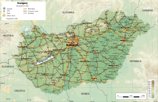
Hungary is a landlocked country in the southeastern region of Central Europe, bordering the Balkans. Situated in the Carpathian Basin, it has a land area of 93,030 square km, measuring about 250 km from north to south and 524 km from east to west. It has 2,106 km of boundaries, shared with Slovakia to the north, Ukraine to the northeast, Romania to the east and southeast, Serbia to the south, Croatia to the southwest, Slovenia to the west and southwest, and Austria to the west.
Located in Eastern Europe, Moldova is bordered on the west and southwest by Romania and on the north, south, and east by Ukraine. Most of its territory lies in Bessarabia region, between the area's two main rivers, the Nistru and the Prut. The Nistru forms a small part of Moldova's border with Ukraine in the northeast and southeast, but it mainly flows through the eastern part of the country, separating Bessarabia and Transnistria. The Prut River forms Moldova's entire western boundary with Romania. The Danube touches the Moldovan border at its southernmost tip, and forms the border for 200 metres (656 ft).
With an area of 238,397 km2 (92,046 sq mi), Romania is the twelfth-largest country in Europe. It is a Balkan country located at the crossroads of Eastern and Southeast Europe. It's bordered on the Black Sea, the country is halfway between the equator and the North Pole and equidistant from the westernmost part of Europe—the Atlantic Coast—and the most easterly—the Ural Mountains. Romania has 3,195 kilometres (1,985 mi) of border. Republic of Moldova and Ukraine lies to the east, Bulgaria lies to the south, and Serbia and Hungary to the west. In the southeast, 245 kilometres (152 mi) of sea coastline provide an important outlet to the Black Sea and the Atlantic Ocean.
The Carpathian Mountains or Carpathians are a range of mountains forming an arc across Central Europe. Roughly 1,500 km (930 mi) long, it is the third-longest European mountain range after the Urals at 2,500 km (1,600 mi) and the Scandinavian Mountains at 1,700 km (1,100 mi). The range stretches from the far eastern Czech Republic (3%) and Austria (1%) in the northwest through Slovakia (21%), Poland (10%), Ukraine (10%), Romania (50%) to Serbia (5%) in the south. The highest range within the Carpathians is known as the Tatra mountains in Poland and Slovakia, where the highest peaks exceed 2,600 m (8,500 ft). The second-highest range is the Southern Carpathians in Romania, where the highest peaks range between 2,500 m (8,200 ft) and 2,550 m (8,370 ft).
The Danube Delta is the second largest river delta in Europe, after the Volga Delta, and is the best preserved on the continent. The greater part of the Danube Delta lies in Romania, with a small part in Ukraine. Its approximate surface area is 4,152 square kilometres, of which 3,446 km2 (1,331 sq mi) is in Romania. With the lagoons of Razim–Sinoe, located south of the main delta, the total area of the Danube Delta is 5,165 km2 (1,994 sq mi). The Razim–Sinoe lagoon complex is geologically and ecologically related to the delta proper; the combined territory is listed as a World Heritage Site.
Muntenia is a historical region of Romania, part of Wallachia. It is situated between the Danube, the Carpathian Mountains and Moldavia, and the Olt River to the west. The latter river is the border between Muntenia and Oltenia. Part of the traditional border between Wallachia/Muntenia and Moldavia was formed by the rivers Milcov and Siret.
Galați is a county (județ) of Romania, in Moldavia region, with the capital city at Galați, between 45°25'N and 46°10'N latitude, 27°20'E and 28°10'E longitude. It borders the counties of Vaslui, Vrancea, Brăila, Tulcea. To the east it borders the Republic of Moldova, the border crossing points being Galați–Giurgiulești and Oancea–Cahul (road). The county was established in 1968, through the territorial reorganization of the former Galați Region, which included a territory similar to that of the current Brăila and Galați counties, plus the northern part of Tulcea County.
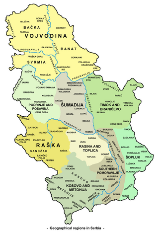
Serbia is a small country situated at the crossroads of Central and Southeast Europe, covering the far southern edges of the Pannonian Plain and the central Balkans. It shares borders with Bosnia and Herzegovina, Bulgaria, Croatia, Hungary, North Macedonia, Montenegro, and Romania. Serbia shares a contested border with Albania as it doesn't recognise the independence of Kosovo. Serbia is landlocked, though it is able to access the Adriatic Sea through Montenegro and inland Europe and the Black Sea via the Danube.
Chernivtsi Oblast, also referred to as Chernivechchyna (Чернівеччина), is an oblast (province) in western Ukraine, consisting of the northern parts of the historical regions of Bukovina and Bessarabia. It has an international border with Romania and Moldova. The region spans 8,100 square kilometres (3,100 sq mi). The oblast is the smallest in Ukraine both by area and population. It has a population of 890,457, and its administrative center is the city of Chernivtsi.
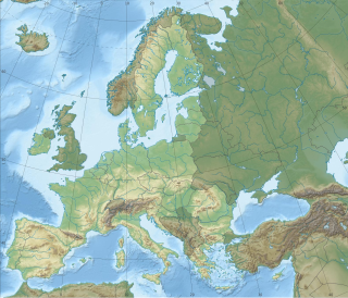
Europe is traditionally defined as one of seven continents. Physiographically, it is the northwestern peninsula of the larger landmass known as Eurasia ; Asia occupies the centre and east of this continuous landmass. Europe's eastern frontier is usually delineated by the Ural Mountains in Russia, which is the largest country by land area in the continent. The southeast boundary with Asia is not universally defined, but the modern definition is generally the Ural River or, less commonly, the Emba River. The boundary continues to the Caspian Sea, the crest of the Caucasus Mountains, and on to the Black Sea. The Bosporus, the Sea of Marmara, and the Dardanelles conclude the Asian boundary. The Mediterranean Sea to the south separates Europe from Africa. The western boundary is the Atlantic Ocean. Iceland is usually included in Europe because it is over twice as close to mainland Europe as mainland North America. There is ongoing debate on where the geographical centre of Europe falls.
The geography of the European Union describes the geographic features of the European Union (EU), a multinational polity that occupies a large portion of Europe and covers 4,422,773 km2 (1,707,642 sq mi). Its European territory extends northeast to Finland, northwest to Ireland, southeast to Cyprus and southwest to the Spanish exclaves on the Mediterranean shores of North Africa. Additionally, the EU includes numerous islands around the world, and French Guiana in South America.
The Pannonian Basin, or Carpathian Basin, is a large sedimentary basin situated in southeast Central Europe. After the WW1 and Treaty of Trianon, the geomorphological term Pannonian Plain became more widely used for roughly the same region though with a somewhat different sense, with only the lowlands, the plain that remained when the Pliocene Epoch Pannonian Sea dried out.
Centru (Centre) is a development region in Romania. As other development regions, it does not have any administrative powers, its main function being to co-ordinate regional development projects and manage funds from the European Union.
The Romanian Plain is located in southern Romania and the easternmost tip of Serbia, where it is known as the Wallachian Plain. It is part of the larger Eurasian Steppe. It is located in the historical region of Wallachia, and bordered by the Danube River in the east, south and west, and by the Getic Plateau in the north. Bucharest, the capital of Romania, is located in the central part of the Romanian Plain. It is contiguous to the south with the Danubian Plain, in Bulgaria. This area is also sometimes referred to as the Danubian Plain(Câmpia Dunării) in Romanian, though this designation is not specific, because the Danube flows through a number of plains along its course, such as the Hungarian Plain, as well as the Bavarian Lowland, also called the Danubian Plain.
The 1970 floods in Romania, brought on by river swelling caused by torrential rains, high winds and a heat wave that melted snow in the Carpathian Mountains, were the worst in modern Romanian history in loss of life, and caused the most damage up to the 2006 floods: at least $500 million; perhaps over $1 billion.
The Moldavian Plateau is a geographic area of the historical region of Moldavia, spanning nowadays the east and northeast of Romania, most of Moldova, and most of the Chernivtsi Oblast of Ukraine.
The hydrology of Hungary, is mostly determined by Hungary's lying in the middle of the Carpathian Basin, half surrounded by the Carpathian Mountains. All parts of the country have some outflow. All surface water gravitates towards its southern center, and from there, is united in the Danube, which flows into the Black Sea. The whole of Hungary lies within the Danube drainage basin.
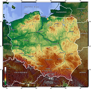
Poland is a country that extends across the North European Plain from the Sudetes and Carpathian Mountains in the south to the sandy beaches of the Baltic Sea in the north. Poland is the fifth-most populous country of the European Union and the ninth-largest country in Europe by area. The territory of Poland covers approximately 312,696 km2 (120,733 sq mi), of which 98.52% is land and 1.48% is water. The Polish coastline was estimated at 770 km (478 mi) in length. Poland's highest point is Rysy, at 2,500 m (8,202 ft).
The Dacian Limes is the generic modern term given to a collection of ramparts and linked series of Roman forts on the frontiers of the Roman province of Dacia dating from the 1st century AD. They ran for about 1,000 km and included the:
This page is based on this Wikipedia article Text is available under the CC BY-SA 4.0 license; additional terms may apply. Images, videos and audio are available under their respective licenses.