Tropical Storm Nalgae (2022)

Last updated

Severe Tropical Storm Nalgae (Paeng)
Severe tropical storm (JMA scale)
Category 1 typhoon (SSHWS)
Nalgae 2022-11-01 0600Z.jpg
Severe Tropical Storm Nalgae at peak intensity on November 1
FormedOctober 26, 2022
DissipatedNovember 3, 2022
Highest winds 10-minute sustained: 110 km/h (70 mph)
1-minute sustained: 130 km/h (80 mph)
Lowest pressure975 hPa (mbar); 28.79 inHg
Fatalities160 reported, 29 missing
Damage$236.55 million (2022 USD)
Areas affected Philippines, South China, Hong Kong, Macau
Part of the 2022 Pacific typhoon season

Severe Tropical Storm Nalgae, known in the Philippines as Severe Tropical Storm Paeng, was a very large and deadly tropical cyclone that wreaked havoc across the Philippines and later impacted Hong Kong and Macau. The 22nd named tropical storm of the 2022 Pacific typhoon season, Nalgae originated from an invest located east of the Philippines on October 26. The disturbance, initially designated as 93W, was eventually upgraded the following day to a tropical depression by the Joint Typhoon Warning Center (JTWC) and re-designated as 26W. The Japan Meteorological Agency (JMA) however, had already considered the disturbance as a tropical depression a day prior to JTWC's; The Philippine Atmospheric, Geophysical and Astronomical Services Administration (PAGASA) also followed the JMA's lead and gave it the name Paeng. That same day, it was upgraded again by the JMA to tropical storm status, thus gaining the name Nalgae.

Contents

Meteorological history

Map plotting the storm's track and intensity, according to the Saffir-Simpson scale

.mw-parser-output .hidden-begin{box-sizing:border-box;width:100%;padding:5px;border:none;font-size:95%}.mw-parser-output .hidden-title{font-weight:bold;line-height:1.6;text-align:left}.mw-parser-output .hidden-content{text-align:left}
Map key
Saffir-Simpson scale
.mw-parser-output .div-col{margin-top:0.3em;column-width:30em}.mw-parser-output .div-col-small{font-size:90%}.mw-parser-output .div-col-rules{column-rule:1px solid #aaa}.mw-parser-output .div-col dl,.mw-parser-output .div-col ol,.mw-parser-output .div-col ul{margin-top:0}.mw-parser-output .div-col li,.mw-parser-output .div-col dd{page-break-inside:avoid;break-inside:avoid-column}
.mw-parser-output .legend{page-break-inside:avoid;break-inside:avoid-column}.mw-parser-output .legend-color{display:inline-block;min-width:1.25em;height:1.25em;line-height:1.25;margin:1px 0;text-align:center;border:1px solid black;background-color:transparent;color:black}.mw-parser-output .legend-text{}
Tropical depression (<=38 mph, <=62 km/h)

Tropical storm (39-73 mph, 63-118 km/h)

Category 1 (74-95 mph, 119-153 km/h)

Category 2 (96-110 mph, 154-177 km/h)

Category 3 (111-129 mph, 178-208 km/h)

Category 4 (130-156 mph, 209-251 km/h)

Category 5 (>=157 mph, >=252 km/h)

Unknown
Storm type
Tropical cyclone
Subtropical cyclone
Extratropical cyclone / Remnant low / Tropical disturbance / Monsoon depression Nalgae 2022 track.png
Map plotting the storm's track and intensity, according to the Saffir–Simpson scale
Map key
  Tropical depression (≤38 mph, ≤62 km/h)
  Tropical storm (39–73 mph, 63–118 km/h)
  Category 1 (74–95 mph, 119–153 km/h)
  Category 2 (96–110 mph, 154–177 km/h)
  Category 3 (111–129 mph, 178–208 km/h)
  Category 4 (130–156 mph, 209–251 km/h)
  Category 5 (≥157 mph, ≥252 km/h)
  Unknown
Storm type
ArrowUp.svg Extratropical cyclone / Remnant low / Tropical disturbance / Monsoon depression

On October 26, 2022, the Joint Typhoon Warning Center (JTWC) reported in its TCFA bulletin that a low pressure area near the Philippines was able to develop because of warm waters and low wind shear. The agency designated it as Invest 93W. [1] The Japan Meteorological Agency (JMA) and the Philippine Atmospheric, Geophysical and Astronomical Services Administration (PAGASA), however, went further and already classified the disturbance as a tropical depression, with the latter assigning the name Paeng to the system. [2] [3] The JTWC would only upgrade the system to a tropical depression a day later, at 00:00 UTC on October 27, and it was given the designation 26W. [4] At the same time, the JMA upgraded the cyclone to a tropical storm, and was named Nalgae. [5] The following day, PAGASA and the JTWC upgraded Nalgae to a severe tropical storm status on October 28. [6] Early next day (local time), Nalgae made its first landfall in Virac, Catanduanes, which was quickly followed by another landfall thirty minutes later in Caramoan, Camarines Sur. It then traversed the Bicol Region and emerged into Ragay Gulf, eventually making landfall in Buenavista, Quezon; the storm maintained its strength during this period. [7] Defying initial forecasts, Nalgae then moved southwestward and struck Mogpog on the island province of Marinduque. [8] Afterwards, the storm moved northwestward into the Sibuyan Sea and struck Sariaya, another municipality in Quezon province; it later moved through Laguna, Rizal, Metro Manila and Bulacan throughout the evening of October 29. [9] [10] Nalgae emerged over the West Philippine Sea the next day, and weakened below tropical storm status. [11] The storm would later re-intensify into a severe tropical storm a few hours later, and eventually exited the Philippine Area of Responsibility a day later. Upon its exit from Philippine jurisdiction, Nalgae then intensified into a Category 1-equivalent typhoon on JTWC; however, the JMA maintained its severe tropical storm classification for the system. It then approached the Pearl River Delta, prompting officials in Hong Kong and Macau to raise Signal No. 8 – the former for 17 hours – from November 1 to 2. [12] [13] [14] At around 04:50 CST on November 3, 2022, Nalgae made its final landfall at Xiangzhou District, Zhuhai as a tropical depression, making it the first tropical cyclone since Nepartak in 2003 to make landfall in China in November.

Preparations

Tropical cyclone wind signals issued for Nalgae by the PAGASA TCWS for Paeng.jpg
Tropical cyclone wind signals issued for Nalgae by the PAGASA

Philippines

Due to Nalgae's threat, PAGASA issued Signal 1 warnings for the Bicol Region and Eastern Visayas. The PAGASA would later upgrade warnings for the Bicol Region and Eastern Visayas to Signal 2 warnings. PAGASA also added Signal 1 warnings for Caraga, Central Visayas, Mimaropa, and Calabarzon. At least 45 people died due to flooding and landslides in Mindanao, all of which occurring a day before the storm made its landfalls. [15] Initially, 72 people were reported to have died, but the death toll was revised by the National Disaster Risk Reduction and Management Council (NDRRMC) because of erroneous counting on the part of local officials; [15] [16] however, the death toll would increase to 112 by November 1 as more bodies were recovered. [17] [18] More than a hundred flights were cancelled in the Philippines on October 28 and 29, most of which going to and coming from Ninoy Aquino International Airport. [19] [20] The storm also delayed the removal of the wreckage of Korean Air Flight 631 after it overran the runway at Mactan–Cebu International Airport. [21] After Nalgae was upgraded to a severe tropical storm, PAGASA put up Tropical Cyclone Wind Signal Number 3 warnings in several areas of Southern Luzon, including Metro Manila. [6]

The Philippine Institute of Volcanology and Seismology (PHIVOLCS) later warned of lahar from Mayon Volcano in Bicol during the tropical storm. [22]

Several airlines based in the Philippines announced that their 124 domestic and international flights were cancelled, as a precautionary measure against the effects of the severe tropical storm.

The Philippine Coast Guard (PCG) announced that maritime travel was suspended in the Bicol Region, Calabarzon and Eastern Visayas regions. [23]

On October 29, the Philippine Basketball Association (PBA), the University Athletic Association of the Philippines (UAAP), the Premier Volleyball League (PVL), the Shakey's Super League (SSL) and the National Collegiate Athletic Association (NCAA) announced that they would postpone their sporting events and games slated for October 29 and 30 as a precautionary measure. [24] [25] PAGASA issued their last bulletins as Nalgae exited the Philippine Area of Responsibility (PAR). After it's exit, it had a death toll of 164 casualties, with 28 remaining missing.

Hong Kong

As Tropical Storm Nalgae tracked closer to Hong Kong, the Hong Kong Observatory issued its third highest strong wind warning (Signal No. 8) on November 3. This is the first time that the warning signal was raised to this level in November in 50 years. [26] The storm came while the city was hosting a financial meeting of senior Wall Street executives; however, despite the said warning and impending impact, the event's organizers announced that it would continue as planned. [27] [28] All warning signals were lifted by November 4. [26]

Macau

The Macao Meteorological and Geophysical Bureau hoisted Signal No 8 in response to Tropical Storm Nalgae. This is the first time the bureau has raised the warning signal to that level in November in 50 years. [29] A state of immediate preparedness was declared in Macau and the Civil Protection Operation Centre was readied. [30]

Impact

RegionDeathsMissingRef.
ReportedConfirmed
Philippines 16010129 [31] [32] [33]
Total15410135

Philippines

Flooding in Cavite. Typhoon Nalgae (Paeng) Cavite floods.jpg
Flooding in Cavite.

By November 6, 156 individuals were reported dead due to landslides and floods made by Nalgae, with 141 others wounded and 37 people remaining missing. Damage to infrastructure is estimated at PHP 4.17 billion (71,490,021.30 USD), while for agriculture, the damage estimate currently stands at PHP 113.51 million. (US$1,946,002.95) [32] On November 2, 2022, President Bongbong Marcos declared a state of calamity over Calabarzon, Bicol, Western Visayas, and the Bangsamoro regions via the President's Proclamation No. 84. [34]

Mindanao–Visayas floods

Flood rescue operation in Zamboanga City Flood Rescue Operation (52461501731).jpg
Flood rescue operation in Zamboanga City

On the island of Mindanao, at least 68 people died [35] [36] due to continuous flooding and landslides that were partially caused by Nalgae. [37] [38] 14 individuals were also confirmed to have been missing; 11 from the Maguindanao province, and 3 from the Soccsksargen region. [37] [39] The floods occurred just as Nalgae had inched closer towards Samar island. Despite the floods and moderate rain, no Wind Signal was given to Bangsamoro. Moderate rain is still expected to continue in the region until Nalgae moves further north in Luzon. [40] In the region of Visayas, rain from Nalgae similarly caused floods in the region. The entire region of Western Visayas was set up to the highest emergency response level due to increasing floods, which has already caused 4 casualties in the province of Aklan. [41] [42] As of November 4, 36 deaths were recorded in Western Visayas. Majority of the fatalities were killed in flashflood and landslides. Antique still has the most number of casualties with 13 followed by Capiz and Iloilo provinces with a total of eight. [43] Central Visayas also experienced light floods and multiple landslides, mostly around the province of Cebu. [44] In Busay, Cebu City, six houses were destroyed from a landslide; however, no casualties were reported as the occupants evacuated before the landslide. [45]

Due to the high death toll, Philippine President Bongbong Marcos criticized local authorities for not forcing residents to immediately evacuate following Nalgae's hit in the country. [46]

Hong Kong and Macau

No casualties were reported in Hong Kong, although one woman was injured and hospitalized. [47] No incidents were reported in Macau. [30]

See also

Other tropical cyclones that had a similar track to Nalgae

Other tropical cyclones that caused flooding in Mindanao and Visayas

Related Research Articles

Typhoons in the Philippines can occur any time of the year, with the months of June to September being most active, with August being the most active individual month and May the least active. Approximately 20 tropical cyclones enter the Philippine area of responsibility yearly, an area which incorporates parts of the Pacific Ocean, the South China Sea, and the Philippine Archipelago. In each year, ten cyclones are usually expected to be typhoons, with five having the potential to be destructive ones. According to a 2013 Time Magazine article, the Philippines is "the most exposed country in the world to tropical storms". In the Philippine languages, tropical cyclones are generally called bagyo.

<span class="mw-page-title-main">2017 Pacific typhoon season</span> Typhoon season in the Western Pacific Ocean

The 2017 Pacific typhoon season was a below-average season in terms of accumulated cyclone energy and the number of typhoons and super typhoons, and the first since the 1977 season to not produce a Category 5-equivalent typhoon on the Saffir–Simpson scale. The season produced a total of 27 named storms, 11 typhoons, and only two super typhoons, making it an average season in terms of storm numbers. It was an event in the annual cycle of tropical cyclone formation, in which tropical cyclones form in the western Pacific Ocean. The season runs throughout 2017, though most tropical cyclones typically develop between May and October. The season's first named storm, Muifa, developed on April 25, while the season's last named storm, Tembin, dissipated on December 26. This season also featured the latest occurrence of the first typhoon of the year since 1998, with Noru reaching this intensity on July 23.

<span class="mw-page-title-main">Tropical Storm Nock-ten</span>

Severe Tropical Storm Nock-ten, known in the Philippines as Tropical Storm Juaning, was a strong tropical storm which made a total of four landfalls in Southeast Asia, killing more than 100 people and causing damage estimated at US$126 million. It was the eighth named storm and the fourth severe tropical storm of the 2011 Pacific typhoon season.

<span class="mw-page-title-main">Typhoon Nanmadol (2011)</span> Pacific typhoon in 2011

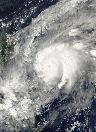
Typhoon Nanmadol, known in the Philippines as Typhoon Mina, was the strongest tropical cyclone in 2011 to hit the Philippines and also the second most intense tropical cyclone worldwide in 2011, and the first of the year to directly impact Taiwan and the rest of the Republic of China (ROC). Becoming the eleventh named storm, the seventh severe tropical storm and the fourth typhoon of the 2011 Pacific typhoon season, Nanmadol made a total of three landfalls killing 26, and causing widespread damage worth US$26,464,591. The area of low pressure that was about to become Nanmadol formed on August 19. It drifted north and became a tropical depression on August 21, a tropical storm on August 23 and a typhoon on the same night. Nanmadol reached peak strength with winds of 105 knots and 140 knots threatening the Philippines with heavy rain and flash flooding.

<span class="mw-page-title-main">Tropical Storm Aere (2011)</span>

Tropical Storm Aere, known in the Philippines as Tropical Storm Bebeng, was a mild tropical storm that affected eastern Philippines and southern Japan. It was the first named storm of the 2011 Pacific typhoon season. Aere is the Marshallese word for storm.

<span class="mw-page-title-main">2020 Pacific typhoon season</span> Typhoon season in the Western Pacific Ocean

The 2020 Pacific typhoon season was the first with below-average tropical cyclone activity since 2001, with 23 named storms, 10 of which became typhoons and only 2 became super typhoons. This low activity was a consequence of La Niña that persisted from the summer of the year. It had the fifth-latest start in the basin on record, slightly behind 1973, and was the first to start that late since 2016. The first half of the season was unusually inactive, with only four systems, two named storms and one typhoon at the end of July. Additionally, the JTWC recorded no tropical cyclone development in the month of July, the first such occurrence since reliable records began. The season's first named tropical cyclone, Vongfong, developed on May 8, while the season's last named tropical cyclone, Krovanh, dissipated on December 24. However, the season's last system was an unnamed tropical depression which dissipated on December 29.

<span class="mw-page-title-main">Tropical Storm Rumbia (2013)</span> Pacific tropical storm in 2013

Severe Tropical Storm Rumbia, known in the Philippines as Tropical Storm Gorio, was a tropical cyclone that brought widespread flooding in areas of the Philippines and China late June and early July 2013. The sixth internationally named storm of the season, Rumbia formed from a broad area of low pressure situated in the southern Philippine Sea on June 27. Steadily organizing, the initial tropical depression moved towards the northwest as the result of a nearby subtropical ridge. On June 28, the disturbance strengthened to tropical storm strength, and subsequently made its first landfall on Eastern Samar in the Philippines early the following day. Rumbia spent roughly a day moving across the archipelago before emerging into the South China Sea. Over open waters, Rumbia resumed strengthening, and reached its peak intensity with winds of 95 km/h (50 mph) on July 1, ranking it as a severe tropical storm. The tropical cyclone weakened slightly before moving ashore the Leizhou Peninsula late that day. Due to land interaction, Rumbia quickly weakened into a low pressure area on July 2 and eventually dissipated soon afterwards.

<span class="mw-page-title-main">Typhoon Chebi (2006)</span> Typhoon

Typhoon Chebi, known in the Philippines as Typhoon Queenie, was a powerful typhoon that impacted Luzon during November 2006. Chebi is the third typhoon since Typhoon Xangsane to hit the country destructively. The 30th tropical depression developed east of the Mariana Islands on October 31 as a weak disturbance. The system was dubbed into a tropical depression on November 8, until both the JMA and PAGASA upgraded it to a tropical storm on November 9. Chebi rapidly intensified to a Category 4 typhoon the next day and made landfall over northern Philippines on November 11. The system finally dissipated near Hong Kong and Vietnam on November 14.

<span class="mw-page-title-main">Typhoon Rammasun</span> Pacific typhoon in 2014

Typhoon Rammasun, known in the Philippines as Typhoon Glenda, was one of the only three Category 5 super typhoons on record in the South China Sea, with the other ones being Pamela in 1954 and Rai in 2021. Rammasun had destructive impacts across the Philippines, South China, and Vietnam in July 2014. Rammasun is a Siamese word for thunder god. After Lingling and Kajiki earlier in 2014, Rammasun became the third tropical cyclone, and first typhoon to directly impact the Philippines in 2014. The ninth named storm and the third typhoon of the annual typhoon season, Rammasun formed in the Intertropical Convergence Zone, an area near the equator where the northeast and southeast trade winds come together, and slowly drifted northwest. Having passed through the islands of Micronesia, the system turned west and quickly moved under the influence of a subtropical ridge (STR). Rammasun posed a significant threat to the Philippine island of Luzon, as it was expected to reach typhoon intensity before making landfall there. Though initially forecast to make landfall in Cagayan Valley, the storm followed a more westerly path and was later forecast to make landfall in the Bicol Region and then pass through Bataan and Zambales before brushing past Metro Manila.

<span class="mw-page-title-main">Effects of the 2013 Pacific typhoon season in the Philippines</span>

The effects of the 2013 Pacific typhoon season in the Philippines were considered some of the worst in decades. Throughout the year, series of typhoons impacted the country, with the worst damage especially death toll from Typhoon Haiyan during November.

<span class="mw-page-title-main">Typhoon Melor</span> Pacific typhoon in 2015

Typhoon Melor, known in the Philippines as Typhoon Nona, was a powerful tropical cyclone that struck the Philippines in December 2015. The twenty-seventh named storm and the eighteenth typhoon of the annual typhoon season, Melor killed 51 people and caused ₱7.04 billion in damage.

<span class="mw-page-title-main">Tropical Storm Haikui (2017)</span> Pacific tropical storm in 2017

Tropical Storm Haikui, known in the Philippines as Tropical Storm Salome, was a weak tropical cyclone that affected the Philippine archipelagos of Luzon and Visayas. Forming as the twenty-fourth named storm of the 2017 typhoon season, Haikui developed as a tropical depression to the east of Samar on November 9. Traversing some Philippine islands, the system gradually intensified into a named tropical storm by November 10. In that same day, Haikui emerged to the South China Sea.

<span class="mw-page-title-main">2022 Pacific typhoon season</span> Typhoon season in the Western Pacific Ocean

The 2022 Pacific typhoon season was the third consecutive season to have below-average tropical cyclone activity, with twenty-five named storms, although it was more active than the previous seasons by named storm count. Ten became typhoons, and three of those intensified into super typhoons. This low activity was caused by a unusually strong La Niña that had persisted from 2020. The season's first named storm, Malakas, developed on April 6, while the last named storm, Pakhar, dissipated on December 12. The season's first typhoon, Malakas, reached typhoon status on April 12. The season ran throughout 2022, though most tropical cyclones typically develop between May and October. Tropical storms Megi and Nalgae were responsible for more than half of the casualties, while typhoons Hinnamnor and Nanmadol both caused $1 billion dollars in damages.

<span class="mw-page-title-main">Tropical Depression Usman</span> Western Pacific tropical depression in 2018

Tropical Depression Usman was a weak but deadly tropical cyclone that impacted the southern Philippines in December 2018. Tropical Depression Usman originated first as a low-pressure area to the east of Palau on December 23. Slowly intensifying, the system became a tropical depression two days later. The system maintained its intensity while moving in a general west-northwestward direction approaching the eastern portion of the Philippine islands. However, due to unfavorable conditions, the depression weakened into a remnant low on December 29, while making landfall over Eastern Samar thereafter.

<span class="mw-page-title-main">Typhoon Kammuri</span> Pacific typhoon in 2019

Typhoon Kammuri, known in the Philippines as Typhoon Tisoy, was a powerful typhoon which impacted the Philippines in early December 2019. The twenty-eighth named storm and sixteenth typhoon of the 2019 Pacific typhoon season, Kammuri developed from a tropical wave situated a couple hundred kilometers south of the Mariana Islands. From November 25 to 27, the system tracked westward at a steady pace and rate of intensification, first making minor impacts in Guam. On November 28, the system intensified into a typhoon as environmental conditions became marginally conducive for significant development. From November 29 to December 1, Kammuri was unable to strengthen to previous estimates due to its near stationary movement as a result of weak steering currents, upwelling itself consequently. On December 2, the system tracked westward at a much faster speed of 19 km/h (12 mph) and rapidly intensified over warm Philippine Sea waters, before making landfall in the Bicol Region of the Philippines at peak intensity as a category 4-equivalent typhoon.

<span class="mw-page-title-main">Typhoon Goni</span> Pacific typhoon in 2020

Typhoon Goni, known in the Philippines as Super Typhoon Rolly, was an extremely powerful tropical cyclone that made landfall as a Category 5 equivalent super typhoon on Catanduanes in the Philippines, and in Vietnam as a tropical storm. It was the strongest landfalling tropical typhoon on record by 1-minute maximum sustained winds. The nineteenth named storm, ninth typhoon, and second super typhoon of the 2020 Pacific typhoon season, Goni originated as a tropical depression south portion of Guam on October 26. It was then named as Tropical Storm Goni on October 27. On the next day, Goni explosively intensified over the Philippine Sea, becoming a Category 5–equivalent super typhoon on October 30. Goni maintained Category 5 strength for over a day, before making landfall on Catanduanes at peak intensity, with 10-minute sustained winds of 220 km/h (140 mph), and 1-minute sustained winds of 315 km/h (195 mph), with a minimum central pressure of 905 hPa. It was the most intense tropical cyclone observed worldwide in 2020, and one of the most intense tropical cyclones on record.

<span class="mw-page-title-main">Tropical Storm Sarika (2011)</span> Pacific tropical storm in 2011

Tropical Storm Sarika, known in the Philippines as Tropical Storm Dodong, was a weak but costly tropical storm that affected Philippines and the East China in early-June 2011. The sixth tropical depression and the third named storm of the 2011 Pacific typhoon season, Sarika formed from an area of low pressure near Cebu City. As it traversed the Verde Island Passage on June 8, both the JTWC and the JMA started issuing advisories on the system, with the former issuing a TCFA on the system later that day. The next day, the PAGASA upgraded the low-pressure area to a tropical depression, naming it Dodong. Moving to the north, the system struggled to intensify due to strong wind shear and was downgraded by the JTWC to a tropical depression; however, the JMA kept the system as a minimal tropical storm until it made landfall near Shantou on June 11. It dissipated soon thereafter.

<span class="mw-page-title-main">Typhoon Rai</span> Pacific typhoon in 2021

Typhoon Rai, known in the Philippines as Super Typhoon Odette, was the second costliest typhoon in Philippine history behind Typhoon Haiyan in 2013. Rai was a powerful rare tropical cyclone that struck the Philippines in December 2021. Rai became the first Category 5-equivalent super typhoon to develop in the month of December since Nock-ten in 2016, and the third Category 5 super typhoon recorded in the South China Sea, following Pamela in 1954 and Rammasun in 2014. The 22nd tropical storm, the ninth typhoon, and the fifth super typhoon of the 2021 Pacific typhoon season, the system originated from a tropical disturbance near the equator on December 10, forming near the site of another low-pressure area that had dissipated on the previous day. Conditions around the system were favorable for further development, and it slowly developed into a tropical depression on December 12. On the same day, the United States Joint Typhoon Warning Center (JTWC) issued a Tropical Cyclone Formation Alert (TCFA) on the consolidating depression. Further intensification ensued, and Rai was upgraded to a tropical storm the next day, before passing south of Ngulu Atoll. After passing near Palau and impacting the island nation, Rai entered the Philippine Area of Responsibility (PAR) by the night of December 14, where the Philippine Atmospheric, Geophysical and Astronomical Services Administration (PAGASA) named it "Odette". On the next day, both the JMA and JTWC raised the system's intensity to a low-end Category 1-equivalent typhoon, as an eye continued to appear. While approaching the Philippines, Rai unexpectedly rapidly intensified into a Category 5 super typhoon for a typhoon with winds of at least 240 km/h (150 mph).</ref> just before its first landfall across Siargao. It then slowly but steadily weakened as it traversed the Visayas, exiting into the Sulu Sea. After making its last landfall over Palawan, Rai continued to weaken before unexpectedly re-intensifying into a Category 5-equivalent typhoon by December 18, while nearing Vietnam. On the next day, Rai entered yet another weakening phase, dissipating on December 22, southeast of Hong Kong.

<span class="mw-page-title-main">Typhoon Nesat (2022)</span> Pacific typhoon in 2022

Typhoon Nesat, known in the Philippines as Typhoon Neneng, was a moderately strong tropical cyclone in the Pacific Ocean. The twentieth named storm and tenth typhoon of the 2022 Pacific typhoon season, Nesat originated from an area of disturbed weather east of the Philippines on October 8. Five days later, it entered the PAGASA's Philippine Area of Responsibility (PAR) and was named Neneng by the weather bureau. The tropical depression then gradually began its intensification in the Philippine Sea and was given the international name of Nesat by the Japan Meteorological Agency after reaching its tropical storm status. On October 16, at 3:50AM Philippine Standard Time, PAGASA noted that Nesat made its first landfall in Calayan Island, Cagayan province as a severe tropical storm; the same agency, then said that Nesat underwent "extreme" rapid intensification. After its landfall, it eventually became a typhoon while in the Luzon Strait as it was making its exit from the PAR. After Nesat's exit on October 17, PAGASA discontinued issuing advisories on the system. The PAGASA issued its last bulletins as it left the PAR.

References

  1. "Current Northwest Pacific/North Indian Ocean Tropical Systems Tropical Cyclone Formation Alert WTPN21 Issued at 26/0200Z". JTWC. October 26, 2022. Archived from the original on October 26, 2022. Retrieved October 26, 2022.
  2. "Weather advisory No. 3 For: Shearline and tropical depression "Paeng" Issued at: 11:00 AM". PAGASA. October 26, 2022. Archived from the original on October 26, 2022. Retrieved October 26, 2022.
  3. "Bulletin released of the tropical depression". Japan Meteorological Agency. October 26, 2022. Archived from the original on October 26, 2022. Retrieved October 26, 2022.
  4. "Tropical Depression 26W (Twentysix) Warning #01 Issued at 27/0300Z". JTWC. October 26, 2022. Archived from the original on October 26, 2022. Retrieved October 26, 2022.
  5. "WWJP27 RJTD 270000". Japan Meteorological Agency. October 26, 2022. Archived from the original on October 26, 2022. Retrieved October 26, 2022.
  6. 1 2 "Paeng strengthens into severe tropical storm; Signal No. 3 up". RAPPLER. October 28, 2022. Retrieved October 28, 2022.
  7. "Severe Tropical Storm Paeng: Forecast track, weather updates, latest news in the Philippines". RAPPLER. Retrieved November 3, 2022.
  8. "Severe Tropical Storm Paeng makes fourth landfall in Marinduque". Rappler. October 29, 2022. Retrieved November 3, 2022.
  9. "Severe Tropical Storm Paeng crosses Laguna after fifth landfall in Quezon". RAPPLER. October 29, 2022. Retrieved November 2, 2022.
  10. ""Paeng" has passed over Laguna de Bay and the Metro Manila-Rizal-Bulacan area" (PDF).
  11. "Tropical Storm Paeng now over West Philippine Sea". RAPPLER. October 29, 2022. Retrieved November 2, 2022.
  12. Mok, Danny; Yeo, Rachel; Ma, Jess; Ng, Kang-chung (November 2, 2022). "Hong Kong cancels all storm signals 17 hours after issuing historic No 8 alert, as Nalgae departs". South China Morning Post. Retrieved November 3, 2022.
  13. "T8 to stay in force as HK waits for Nalgae to weaken – RTHK". RTHK. RTHK.hk English News. November 2, 2022. Retrieved November 3, 2022.
  14. Leung, Kanis (November 2, 2022). "Hong Kong braces for Tropical Storm Nalgae". ABC News. Retrieved November 3, 2022.
  15. 1 2 Mangaluz, Jean (October 29, 2022). "Severe Tropical Storm Paeng death toll climbs to 45 – NDRRMC | Inquirer News". inquirer.net. Philippine Daily Inquirer. Retrieved October 29, 2022.
  16. AFP. "Death toll from Philippine flash floods rises to 67 – official tally". GMA News Online. Retrieved October 28, 2022.
  17. "Tropical storm Nalgae: 98 dead in one of most destructive storms to hit Philippines this year". The Guardian . October 31, 2022. Retrieved October 31, 2022.
  18. Yabut, Angel; Mangosing, Frances (November 2, 2022). "Direr Paeng picture forms: 112 dead, 161 calamity areas". inquirer.net. Inquirer News . Retrieved November 3, 2022. More deaths have been recorded due to landslides and flooding triggered by the heavy rainfall brought by Severe Tropical Storm "Paeng" (international name: Nalgae), raising the number of fatalities nationwide to 112, the National Disaster Risk Reduction and Management Council (NDRRMC) said on Tuesday [November 1, 2022].
  19. ABS-CBN News [@ABSCBNNews] (October 29, 2022). "ABS-CBN News on Twitter: "FLIGHT ADVISORY: 124 cancelled flights to and from NAIA as of 3:20 p.m. due to #PaengPH. (via @MIAAGovPH) | via @jacquemanabat t.co/fspHZuZSyk"" (Tweet) via Twitter.
  20. "LIST: Canceled flights for October 28 amid 'Paeng' rains". Philstar.com. Retrieved October 28, 2022.
  21. "Inclement weather stalls removal operations of crashed Korean aircraft". CebuDailyNews. October 28, 2022. Retrieved October 28, 2022.
  22. "LAHAR ADVISORY FOR MAYON VOLCANO UNDER TROPICAL STORM PAENG (NALGAE) 28 October 2022 7:00 pm". PHIVOLCS. October 28, 2022. Retrieved October 30, 2022.
  23. "Typhoon Paeng: 4.5K travelers affected as PCG suspends sea trips in Bicol, Southern Tagalog, E. Visayas". Manila Bulletin. October 28, 2022. Retrieved October 30, 2022.
  24. Bacnis, Justine (October 29, 2022). "PBA suspends Saturday matches due to Paeng". Tiebreaker Times. Retrieved October 30, 2022.
  25. "Local sports action wiped out as Paeng strengthens". Rappler. October 29, 2022. Retrieved October 30, 2022.
  26. 1 2 "Hong Kong cancels all storm signals, 17 hours after issuing historic No 8 alert". South China Morning Post. November 2, 2022. Retrieved November 5, 2022.
  27. "Hong Kong braces for storm Nalgae as city hosts financial meeting". Reuters. November 1, 2022. Retrieved November 2, 2022.
  28. Leung, Kanis (November 2, 2022). "Hong Kong businesses brace for Tropical Storm Nalgae impact". ABC News. Retrieved November 2, 2022.
  29. Dias, Erico (November 4, 2022). "Typhoon Nalgae marked first November hoisting of Signal No 8 in 50 years". Macao News. Retrieved November 5, 2022.
  30. 1 2 "Typhoon Nalgae: no incidents or casualties registered in Macau". TDM - Teledifusão de Macau, S.A. November 3, 2022. Retrieved November 5, 2022.
  31. "NDRRMC: 'Paeng' disrupted lives of nearly 4M, left at least 150 dead". Philstar.com. Philstar Global. November 3, 2022. Retrieved November 3, 2022.
  32. 1 2 Domingo, Katrina (November 5, 2022). "Paeng death toll now at to 155 — NDRRMC". ABS-CBN News. Retrieved November 5, 2022.
  33. "Philippines: Severe Tropical Storm Nalgae (Paeng), Mindanao - Consolidated Rapid Assessment Report (7 November 2022) - Philippines | ReliefWeb". reliefweb.int. Retrieved November 28, 2022.
  34. "PBBM declares state of calamity in 'Paeng'-hit regions". Philippine Information Agency. November 2, 2022. Retrieved November 5, 2022.
  35. "Death toll from 'Paeng' hits 121". Philstar.com. Philstar Global. November 2, 2022. Retrieved November 2, 2022. The Bangsamoro Autonomous Region in Muslim Mindanao accounted for most of the fatalities with 61 deaths... Fatalities were also reported in the following regions: Western Visayas with 29, Calabarzon with 12, Eastern Visayas with five, Zamboanga Peninsula with four, Soccsksargen with three, Mimaropa and Central Visayas with two each, and Central Luzon, Bicol region and the Cordillera Administrative Region with one each.
  36. De Leon, Dwight (November 2, 2022). "NDRRMC: Paeng death toll now at 121". Rappler. Retrieved November 2, 2022.
  37. 1 2 "Floods swamp PH, as death toll climbs to 45". The Manila Times. October 30, 2022. Retrieved October 30, 2022.
  38. Morales, Neil Jerome (October 29, 2022). "Philippines president orders urgent aid as storm Nalgae kills 45". Reuters. Retrieved October 30, 2022.
  39. "Philippine officials revise 'Paeng' death toll down to 45". Philstar.com. Retrieved October 30, 2022.
  40. Mendoza, John Eric (October 28, 2022). "31 dead as Paeng triggers flash floods, landslides in Maguindanao del Norte". INQUIRER.net. Retrieved October 29, 2022.
  41. "Western Visayas on highest emergency response level, high risk for floods". RAPPLER. October 27, 2022. Retrieved October 29, 2022.
  42. "4 dead in Aklan; thousands of families flee floods in Panay, Negros islands". RAPPLER. October 28, 2022. Retrieved October 29, 2022.
  43. "'Paeng' death toll in Western Visayas rises to 36". MANILA BULLETIN. November 4, 2022. Retrieved November 5, 2022.
  44. "Storm Paeng spawns floods, landslides in Central Visayas". October 29, 2022. Retrieved October 29, 2022.
  45. "Landslide in Cebu City destroys 6 houses". Manila Bulletin. October 29, 2022. Retrieved October 30, 2022.
  46. Mendoza, John Eric (October 29, 2022). "Bongbong Marcos on Paeng death toll: Why were they not evacuated immediately?". INQUIRER.net. Inquirer News . Retrieved November 3, 2022.
  47. "Forecasters say weather expected to settle next week after Tropical Storm Nalgae". South China Morning Post. November 3, 2022. Retrieved November 5, 2022.