General information | |||||||||||
---|---|---|---|---|---|---|---|---|---|---|---|
Location | Osmeña Highway, San Andres | ||||||||||
Coordinates | 14°34′1.56″N121°0′10.14″E / 14.5671000°N 121.0028167°E | ||||||||||
Owned by | Philippine National Railways | ||||||||||
Operated by | Philippine National Railways | ||||||||||
Line(s) | South Main Line | ||||||||||
Platforms | Side platforms | ||||||||||
Tracks | 2 | ||||||||||
Connections | Jeepneys, buses, and tricycles | ||||||||||
Construction | |||||||||||
Structure type | At-grade | ||||||||||
Accessible | Yes | ||||||||||
Other information | |||||||||||
Station code | VTC | ||||||||||
History | |||||||||||
Opened | 1975 | ||||||||||
Rebuilt | 1990 and 2009 | ||||||||||
Services | |||||||||||
| |||||||||||
Location | |||||||||||
PNR Metro Commuter | |||||||||||||||||||||||||||||||||||||||||||||||||||||||||||||||||||||||||||||||||||||||||||||||||||||||||||||||||||||||||||||||||||||||||||||||||||||||||||||||||||||||||||||||||||||||||||||||||||||||||||||||||||||||||||||||||||||||||||||||||||||||||||||||||||||||||||||||||||||||||||||||||||||||||||||||||||||||||||||||||||||||||||||||||||||||||||||||||||||||||||||||||||||||||||||||||||||||||||||||||||||||||||||||||||||||||||||||||||||||||||||||||||||||||||||||||||||||||||||||||||||||||||||||||||||||||||||||||||||||||||||||||||||||||||||||||||||||||||||||||||||||||||||||||||||||
---|---|---|---|---|---|---|---|---|---|---|---|---|---|---|---|---|---|---|---|---|---|---|---|---|---|---|---|---|---|---|---|---|---|---|---|---|---|---|---|---|---|---|---|---|---|---|---|---|---|---|---|---|---|---|---|---|---|---|---|---|---|---|---|---|---|---|---|---|---|---|---|---|---|---|---|---|---|---|---|---|---|---|---|---|---|---|---|---|---|---|---|---|---|---|---|---|---|---|---|---|---|---|---|---|---|---|---|---|---|---|---|---|---|---|---|---|---|---|---|---|---|---|---|---|---|---|---|---|---|---|---|---|---|---|---|---|---|---|---|---|---|---|---|---|---|---|---|---|---|---|---|---|---|---|---|---|---|---|---|---|---|---|---|---|---|---|---|---|---|---|---|---|---|---|---|---|---|---|---|---|---|---|---|---|---|---|---|---|---|---|---|---|---|---|---|---|---|---|---|---|---|---|---|---|---|---|---|---|---|---|---|---|---|---|---|---|---|---|---|---|---|---|---|---|---|---|---|---|---|---|---|---|---|---|---|---|---|---|---|---|---|---|---|---|---|---|---|---|---|---|---|---|---|---|---|---|---|---|---|---|---|---|---|---|---|---|---|---|---|---|---|---|---|---|---|---|---|---|---|---|---|---|---|---|---|---|---|---|---|---|---|---|---|---|---|---|---|---|---|---|---|---|---|---|---|---|---|---|---|---|---|---|---|---|---|---|---|---|---|---|---|---|---|---|---|---|---|---|---|---|---|---|---|---|---|---|---|---|---|---|---|---|---|---|---|---|---|---|---|---|---|---|---|---|---|---|---|---|---|---|---|---|---|---|---|---|---|---|---|---|---|---|---|---|---|---|---|---|---|---|---|---|---|---|---|---|---|---|---|---|---|---|---|---|---|---|---|---|---|---|---|---|---|---|---|---|---|---|---|---|---|---|---|---|---|---|---|---|---|---|---|---|---|---|---|---|---|---|---|---|---|---|---|---|---|---|---|---|---|---|---|---|---|---|---|---|---|---|---|---|---|---|---|---|---|---|---|---|---|---|---|---|---|---|---|---|---|---|---|---|---|---|---|---|---|---|---|---|---|---|---|---|---|---|---|---|---|---|---|---|---|---|---|---|---|---|---|---|---|---|---|---|---|---|---|---|---|---|---|---|---|---|---|---|---|---|---|---|---|---|---|---|---|---|---|---|---|---|---|---|---|---|---|---|---|---|---|---|---|---|---|---|---|---|---|---|---|---|---|---|---|---|---|---|---|---|---|---|---|---|---|---|---|---|---|---|---|---|---|---|---|---|---|---|---|---|---|---|---|---|---|---|---|
|
Vito Cruz station is a railway station located on the South Main Line in the city of Manila, Philippines. The station derives its name from the former name of the adjacent now Pablo Ocampo Sr. Street, which is Vito Cruz Street, after a former alcalde mayor of Pineda (present-day Pasay).
Vito Cruz is the eighth station from Tutuban and is the last station on the South Main Line physically located in the city of Manila.
Vito Cruz, together with Buendia, was opened on November 24, 1975 as part of the 83rd anniversary of the Philippine National Railways.
The station serves the district of San Andres in Manila, as well as nearby barangays San Antonio, La Paz, and Palanan in Makati. Adjacent landmarks include Barangay 764's Barangay Action Center along Perlita Street and some commercial establishments. Further away from the station are educational institutions such as the main campus of Arellano University School of Law, the De La Salle University, the De La Salle–College of Saint Benilde and St. Scholastica's College, the Manila South Cemetery.
Vito Cruz station is accessible by jeepneys plying the Zobel Roxas Street route, as well as buses on the Osmeña Highway. A tricycle terminal plying barangay San Antonio in Makati is located across the station on Zobel Roxas Street, while tricycles based in Manila and barangay Palanan, Makati also drop commuters off at the station.
L1 Platforms | Side platform, doors will open on the right | |
Platform A | PNR Metro Commuter towards Tutuban (←) | |
Platform B | PNR Metro Commuter towards Alabang (→) | |
Side platform, doors will open on the right | ||
L1 | Concourse/ Street Level | Ticket Booths, Station Control |
Makati, officially the City of Makati, is a highly urbanized city in the National Capital Region of the Philippines.
Vito Cruz station is an elevated Light Rail Transit (LRT) station located on the LRT Line 1 (LRT-1) system in Malate, Manila. It is the first station from Baclaran and the last station from Fernando Poe Jr. to lie within Manila city bounds. The station takes its name from the former Vito Cruz Street, which was named after a former alcalde mayor of Pineda c. 1871.
Magallanes station is an elevated Metro Rail Transit (MRT) station located on the MRT Line 3 (MRT-3) system in Makati. The station is named after barangay Magallanes of Makati, which in turn is named after Ferdinand Magellan, who discovered the Philippines for Spain on April 15, 1521. Although the station is named after Magallanes, it also serves passengers from Kayamanan-C and barangays Dasmariñas, Pio del Pilar, and San Lorenzo in Makati, and those from Taguig.
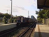
Buendia station is a former railway station located on the South Main Line in Makati, Metro Manila, Philippines.
Taft Avenue is a major road in the south of Metro Manila. It passes through three cities in the metropolis: Manila, Pasay, and Parañaque. The road was named after the former Governor-General of the Philippines and U.S. President, William Howard Taft; the Philippines was a former commonwealth territory of the United States in the first half of the 20th century. The avenue is a component of National Route 170 (N170), a secondary road in the Philippine highway network, and anchors R-2 of the Manila arterial road network.
Poblacion is an administrative division of southern Metro Manila, the Philippines. It is an urban barangay of Makati, named and centered on the city's historic poblacion area and serves as the second most important commercial center in Makati behind the Makati Central Business District. It is also the city's center of government, culture, history and entertainment and a major business district of Metro Manila.
Senator Gil J. Puyat Avenue, also known simply as Gil Puyat Avenue and by its former official name Buendia Avenue, is a major arterial thoroughfare which travels east–west through the cities of Makati and Pasay in western Metro Manila, Philippines. It is one of the busiest avenues in Metro Manila linking the Makati Central Business District with the rest of the metropolis.
Pablo Ocampo Street, also known simply as Ocampo Street and formerly and still referred to as Vito Cruz Street, is an inner city main road in Manila, Philippines. It runs west–east for about 3.448 kilometers (2.142 mi) connecting the southern districts of Malate and San Andres southeast to the adjacent city of Makati.
Antonio Arnáiz Avenue, also known simply as Avenida Arnáiz and by its former official name Pásay Road, is a major east–west collector road that links Makati and Pasay in the Philippines. It stretches across western Metro Manila from Roxas Boulevard in Pasay to Epifanio de los Santos Avenue (EDSA) in Makati.
J. P. Rizal Avenue, also known as J. P. Rizal Street, is a major local avenue in Makati and Taguig, Metro Manila, Philippines. It is a contour collector road on the south bank of the Pasig River that runs east–west from Pateros Bridge at the Taguig–Pateros boundary to its intersection with Zobel Roxas, Delpan, and Tejeron Streets at the Makati–Manila boundary. The avenue was named after the Philippines' national hero, Dr. José P. Rizal.
Kalayaan Avenue is a major east–west route in Makati and Taguig, Metro Manila, Philippines. For most of its length, it runs parallel to Jose P. Rizal Avenue to the north from East Rembo near Fort Bonifacio to Barangay Singkamas by the border with Santa Ana, Manila. It is interrupted by Bel-Air Village between Rockwell Drive and Epifanio de los Santos Avenue (EDSA). The avenue east of EDSA is designated as a component of National Route 190 of the Philippine highway network.
Zobel Roxas Street is an east-west street that forms the southeastern limit of the City of Manila, the northwestern city limit of Makati, and the northern city limit of Pasay, all in Metro Manila, Philippines. It stretches across western Metro Manila from F. Muñoz Street in the Singalong area of Malate to Tejeron Street at the district boundary of San Andres Bukid and Santa Ana. It has a short extension northeast of the Tejeron Street–J.P. Rizal Avenue junction as Del Pan Street.
The Makati Central Business District is a financial and central business district in the Philippines located in the heart of Makati in Metro Manila. It is politically known as "Central Cluster" in the West District of Makati. It is different from the Makati civic center known as "Makati Poblacion" which is situated at the northeast portion of the district. It is bounded by EDSA, Amorsolo Street, Ayala Avenue, Gil Puyat Avenue, Osmeña Highway, Zobel Roxas Street, Ocampo Street, Metropolitan Avenue, Nicanor Garcia Street, Kalayaan Avenue, Makati Avenue, Anza Street, Polaris Street, Orion Street, Mercedes Street, Amapola Street and Estrella Street. The whole district occupies barangays of San Antonio, San Lorenzo, Bel-Air, and Urdaneta.
Radial Road 4 (R-4), informally known as the R-4 Road, is a network of roads and bridges that all together form the fourth arterial road of Metro Manila in the Philippines. Spanning some 23.5 kilometers (14.6 mi), it connects the cities and municipalities of Makati, Manila, Pasig, Pateros, Taguig, and Taytay in Metro Manila and Rizal.
The following is an alphabetical list of articles related to the Philippine capital region of Metro Manila.
The President Sergio Osmeña Sr. Highway, also known as the South Superhighway, is a 4.595-kilometer (2.855 mi) major highway that links Quirino Avenue in Paco, Manila to Epifanio de los Santos Avenue (EDSA) and South Luzon Expressway (SLEX) at the Magallanes Interchange in Makati.
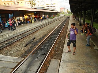
Dela Rosa station is a railway station located on the South Main Line in Makati, Metro Manila, Philippines.
The Makati Poblacion Park, often shortened to Poblacion Park, is an urban linear park along the south bank of the Pasig River in Metro Manila, the Philippines. As its name suggests, it is located in Barangay Poblacion, Makati and was formerly known as Casa Hacienda Park. The park is the largest of three public parks in Makati's old downtown area situated at the site of a former plantation house. It is operated by the Department of Environmental Services Parks and Green Division of the City Government of Makati. Together with the Makati Poblacion Linear Park, the park has revitalized around 0.25 kilometers (0.16 mi) of Makati Poblacion's waterfront between the Makati-Mandaluyong Bridge and Rockwell Center.
San Antonio is an administrative division in southern Metro Manila, the Philippines. It is a collection of sixteen gated communities on the east side of Parañaque abutting the city of Muntinlupa, and the informal settlements surrounding them. The barangay is a long strip along the north side of Dr. Santos Avenue stretching from South Luzon Expressway to just west of San Antonio Avenue by the Jaka Plaza commercial center. It is bordered by Marcelo Green to the north, the Muntinlupa barangay of Sucat across the expressway to the east, BF Homes Parañaque across Dr. Santos Avenue to the south, and San Isidro and Moonwalk to the west. It extends to the northwest along San Antonio Avenue and also shares a border with Don Bosco further north and northwest. The barangay is part of the Parañaque's 2nd congressional district.
Don Bosco is an administrative division in Parañaque, Metro Manila, Philippines. It is one of sixteen barangays that make up the city of Parañaque situated along either side of Doña Soledad Avenue from South Luzon Expressway west to Diamond Street in Cecilia Village. Part of the Parañaque 2nd district, Don Bosco is the third largest barangay in the city and is bordered by Don Bosco Creek which separates it from Merville's namesake gated community, Country Village and Lion's Park Residences to the north, Sun Valley's namesake gated village and Siena Park to the northeast, San Martin de Porres across the South Luzon Expressway to the east, Marcelo Green to the southeast, Baloc-Baloc Creek which separates it from San Antonio's namesake community, Greenheights Village and Malacañang Village to the south, and Moonwalk's namesake community, Airport Village and Multinational Village to the west.