West Miami, Florida

Last updated

West Miami, Florida
City of West Miami
Flag of West Miami, Florida.svg
Seal of West Miami.png
Motto: 
Miami-Dade County Florida Incorporated and Unincorporated areas West Miami Highlighted.svg
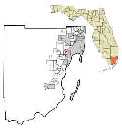
Location in Miami-Dade County and the U.S. state of Florida
West Miami.gif
U.S. Census Bureau map showing city limits
Coordinates: 25°45′26″N80°17′48″W / 25.75722°N 80.29667°W / 25.75722; -80.29667
Country Flag of the United States.svg United States
State Flag of Florida.svg  Florida
County Flag of Miami-Dade County, Florida.png Miami-Dade
Incorporated April 7, 1947
Government
  Type Council-Manager
   Mayor Eric Diaz-Padron
   Vice Mayor Juan M. Blanes
   Commissioners Candida Blanca,
Luciano L. Suarez, and
Ivan Chavez, Jr.
   City Manager Edward Silva
   City Clerk Annery Gonzalez
Area
[2]
  Total0.71 sq mi (1.84 km2)
  Land0.71 sq mi (1.84 km2)
  Water0.00 sq mi (0.00 km2)
Elevation
9 ft (3 m)
Population
 (2020) [3]
  Total7,233
  Density10,201.69/sq mi (3,939.14/km2)
Time zone UTC-5 (Eastern (EST))
  Summer (DST) UTC-4 (EDT)
ZIP codes
33144, 33155 (Miami)
Area code(s) 305, 786, 645
FIPS code 12-76525 [4]
GNIS feature ID0293093 [5]
Website www.cityofwestmiamifl.com

West Miami is a city in Miami-Dade County, Florida, United States. The city is part of the Miami metropolitan area of South Florida. The population was 7,233 at the 2020 census, [3] up from 5,965 in 2010. [6]

Contents

Geography

West Miami is located 6 miles (10 km) west of downtown Miami at 25°45′26″N80°17′48″W / 25.75722°N 80.29667°W / 25.75722; -80.29667 (25.757691, –80.296583). [7] It is bordered to the north by Miami, to the east by Coral Gables, and to the south and west by unincorporated Coral Terrace.

According to the United States Census Bureau, West Miami has a total area of 0.7 square miles (1.8 km2), all land. [2]

Surrounding areas

History

The city of West Miami, which is less than three-quarters of a square mile in area, is nestled between Tamiami Trail and Coral Way. Among early suggested names for the city were West Haven and West Gate.

Incorporated as a town with 700 residents, West Miami had 7,233 residents as of the 2020 census. 88.54% of the population was Hispanic or Latino. West Miami is surrounded by its larger neighbors, Coral Gables and Miami. [8]

Demographics

Historical population
CensusPop.Note
1950 4,043
1960 5,29631.0%
1970 5,4943.7%
1980 6,07610.6%
1990 5,727−5.7%
2000 5,8632.4%
2010 5,9651.7%
2020 7,23321.3%
U.S. Decennial Census [9]

2020 census

West Miami racial composition
(Hispanics excluded from racial categories)
(NH = Non-Hispanic) [10]
RaceNumberPercentage
White (NH)6008.30%
Black or African American (NH)961.33%
Native American or Alaska Native (NH)00.00%
Asian (NH)500.69%
Pacific Islander or Native Hawaiian (NH)10.01%
Some Other Race (NH)220.30%
Two or more races/Multiracial (NH)600.83%
Hispanic or Latino (any race)6,40488.54%
Total7,233100.00%

As of the 2020 United States census, there were 7,233 people, 2,949 households, and 2,021 families residing in the city. [11]

2010 census

West Miami Demographics
2010 Census West MiamiMiami-Dade CountyFlorida
Total population5,9652,496,43518,801,310
Population, percent change, 2000 to 2010+1.7%+10.8%+17.6%
Population density8,417.6/sq mi1,315.5/sq mi350.6/sq mi
White or Caucasian (including White Hispanic)95.0%73.8%75.0%
(Non-Hispanic White or Caucasian)9.1%15.4%57.9%
Black or African-American 1.3%18.9%16.0%
Hispanic or Latino (of any race) 90.2%65.0%22.5%
Asian 0.2%1.5%2.4%
Native American or Native Alaskan 0.2%0.2%0.4%
Pacific Islander or Native Hawaiian 0.0%0.0%0.1%
Two or more races (Multiracial) 1.3%2.4%2.5%
Some Other Race 2.0%3.2%3.6%

As of the 2010 United States census, there were 5,965 people, 2,194 households, and 1,502 families residing in the city. [12]

2000 census

In 2000, 26.9% had children under the age of 18 living with them, 54.3% were married couples living together, 17.3% had a female householder with no husband present, and 23.0% were non-families. 18.3% of all households were made up of individuals, and 10.7% had someone living alone who was 65 years of age or older. The average household size was 2.80 and the average family size was 3.14.

In 2000, the city, the population was spread out, with 18.4% under the age of 18, 5.9% from 18 to 24, 27.7% from 25 to 44, 22.5% from 45 to 64, and 25.6% who were 65 years of age or older. The median age was 43 years. For every 100 females, there were 83.3 males. For every 100 females age 18 and over, there were 81.3 males.

In 2000, the median income for a household in the city was $34,910, and the median income for a family was $39,000. Males had a median income of $26,875 versus $26,013 for females. The per capita income for the city was $17,850. About 7.6% of families and 9.5% of the population were below the poverty line, including 14.3% of those under age 18 and 7.4% of those age 65 or over.

As of 2000, Spanish as a first language was at 87.39% of residents, while English spoken as the mother tongue was 12.61% of the population. [13]

Public transportation

Parks

Notable people

Crime

The number of violent crimes recorded by the FBI in 2003 was 22, with no homicides. The violent crime rate was 3.6 per 1,000 people. [14]

Related Research Articles

<span class="mw-page-title-main">Andover, Florida</span> Neighborhood of Miami Gardens in Miami-Dade, Florida, United States

Andover is a neighborhood in Miami Gardens, Florida. It was formerly a census-designated place. The population was 8,489 at the 2000 census. Transmitters for several Miami television stations are located in Andover.

<span class="mw-page-title-main">Coral Gables, Florida</span> City in Miami-Dade County, Florida

Coral Gables is a city in Miami-Dade County, Florida, United States. The city is part of the Miami metropolitan area of South Florida and is located 7 miles (11 km) southwest of Downtown Miami. As of the 2020 U.S. census, it had a population of 49,248.

<span class="mw-page-title-main">Coral Terrace, Florida</span> Census-designated place in Florida

Coral Terrace is a suburban unincorporated community and census-designated place (CDP) in Miami-Dade County, Florida, United States. It is part of the Miami metropolitan area of South Florida. The population was 23,142 at the 2020 census, down from 24,376 in 2010.

<span class="mw-page-title-main">Country Walk, Florida</span> Census-designated place in Florida

Country Walk is a census-designated place (CDP) in Miami-Dade County, Florida, United States. It is part of the Miami metropolitan area of South Florida. The population was 16,951 at the 2020 census, up from 15,997 at the 2010 census.

<span class="mw-page-title-main">El Portal, Florida</span> Village in Florida

El Portal is a village in Miami-Dade County, Florida, United States. The name is derived from the Spanish term for "the gate", after two wooden gates that once stood as a gateway to the village. El Portal was originally annexed into the city of Miami in 1925. With the arrival of the Great Depression, Miami gave up its jurisdiction, and El Portal was incorporated as its own village in 1937. The village is part of the Miami metropolitan area of South Florida. As of the 2020 census, the population of El Portal was 1,986, down from 2,325 in 2010.

<span class="mw-page-title-main">Gladeview, Florida</span> Census-designated place in Florida

Gladeview is a census-designated place (CDP) in Miami-Dade County, Florida, United States. It is part of the Miami metropolitan area of South Florida. The population was 14,927 at the 2020 census, up from 11,535 in 2010.

<span class="mw-page-title-main">Glenvar Heights, Florida</span> Census-designated place in Florida

Glenvar Heights is a census-designated place (CDP) and neighborhood in Miami-Dade County, Florida, United States. It is part of the Miami metropolitan area of South Florida. The population was 20,786 at the 2020 US census, up from 16,898 in 2010 US census.

<span class="mw-page-title-main">Hialeah Gardens, Florida</span> City in Florida

Hialeah Gardens is a city in Miami-Dade County, Florida, United States. The city is part of the Miami metropolitan area of South Florida. The population was 23,068 at the 2020 US census, up from 21,744 in 2010. The population density is mostly made up of single-story development.

<span class="mw-page-title-main">Kendall, Florida</span> Census-designated place in Florida

Kendall is an unincorporated area and census-designated place in Miami-Dade County, Florida. It is part of the Miami metropolitan area of South Florida. At the 2020 census, the area had a population of 80,241.

<span class="mw-page-title-main">Leisure City, Florida</span> Census-designated place in Florida

Leisure City is an unincorporated community and census-designated place (CDP) in Miami-Dade County, Florida, United States, that includes the smaller, older community of Modello in its northwestern section. The CDP is most notable for the Coral Castle Museum, located in the Modello area. It is located in the Miami metropolitan area of South Florida. The population was 26,324 at the 2020 census, up from 22,655 in 2010.

<span class="mw-page-title-main">Olympia Heights, Florida</span> Census-designated place in Florida

Olympia Heights is a census-designated place in Miami-Dade County, Florida, United States. It is located in the Miami metropolitan area of South Florida. The population was 12,873 at the 2020 census.

<span class="mw-page-title-main">Palm Springs North, Florida</span> Census-designated place in Florida

Palm Springs North is an unincorporated community and census-designated place (CDP) in Miami-Dade County, Florida, United States. It is part of the Miami metropolitan area of South Florida. The population was 5,030 at the 2020 census.

<span class="mw-page-title-main">Richmond West, Florida</span> Census-designated place in Florida

Richmond West is a census-designated place (CDP) in Miami-Dade County, Florida, United States. It is part of the Miami metropolitan area of South Florida. The population was 35,884 at the 2020 census, up from 31,973 at the 2010 census.

<span class="mw-page-title-main">Sweetwater, Miami-Dade County, Florida</span> City in Florida

Sweetwater is a city in Miami-Dade County, Florida, United States. The city is part of the Miami metropolitan area of South Florida. As of the 2020 census, the population was 19,363, up from 13,499 in 2010.

<span class="mw-page-title-main">Tamiami, Florida</span> Census-designated place in Florida

Tamiami is a census-designated place (CDP) in Miami-Dade County, Florida, United States. It is part of the Miami metropolitan area of South Florida. The population was 54,212 at the 2020 census.

<span class="mw-page-title-main">The Crossings, Florida</span> CDP in Florida

The Crossings is a census-designated place (CDP) and suburb of Miami in Miami-Dade County, Florida, United States. It is part of the Miami metropolitan area of South Florida. The CDP includes the neighborhoods of The Crossings, Devon Aire, and Calusa. The population was 23,276 at the 2020 census.

<span class="mw-page-title-main">Virginia Gardens, Florida</span> Village in Florida

Virginia Gardens is a village in Miami-Dade County, Florida, United States. The village is a part of the Miami metropolitan area of South Florida. According to the U.S. Census Bureau, the village had a population of 2,364 in 2020.

<span class="mw-page-title-main">Westchester, Florida</span> Census-designated place in Florida

Westchester is a census-designated place (CDP) and neighborhood in Miami-Dade County, Florida. It is part of the Miami metropolitan area of South Florida. Prior to the 2020 U.S. Census, the neighboring University Park CDP was merged into Westchester CDP, effectively doubling its geography and population. Per the 2020 census, the population was 56,384.

<span class="mw-page-title-main">Westwood Lakes, Florida</span> Census-designated place in Florida

Westwood Lakes is a census-designated place and unincorporated community of Miami-Dade County, Florida, United States. It is part of the Miami metropolitan area of South Florida. The population was 11,373 at the 2020 census.

<span class="mw-page-title-main">Palmetto Bay, Florida</span> Village in Florida

Palmetto Bay is a suburban incorporated village in Miami-Dade County, Florida, United States. Palmetto Bay includes two neighborhoods that were former census-designated places, Cutler and East Perrine. The village is part of the Miami metropolitan area of South Florida. The population was 24,439 as of the 2020 US census.

References

  1. "City Seals in Miami-Dade Are Mostly Terrible, but We Ranked Them Anyway".
  2. 1 2 "2022 U.S. Gazetteer Files: Florida". United States Census Bureau. Retrieved December 28, 2022.
  3. 1 2 "P1. Race – West Miami city, Florida: 2020 DEC Redistricting Data (PL 94-171)". U.S. Census Bureau. Retrieved December 28, 2022.
  4. "U.S. Census website". United States Census Bureau . Retrieved January 31, 2008.
  5. "US Board on Geographic Names". United States Geological Survey. October 25, 2007. Retrieved January 31, 2008.
  6. "P1. Race – West Miami city, Florida: 2020 DEC Redistricting Data (PL 94-171)". U.S. Census Bureau. Retrieved December 28, 2022.
  7. "US Gazetteer files: 2010, 2000, and 1990". United States Census Bureau. February 12, 2011. Retrieved April 23, 2011.
  8. Community Links: Coral Gables & South Miami Area - MiamiHerald.com
  9. "Census of Population and Housing". Census.gov. Retrieved June 4, 2015.
  10. "Explore Census Data". data.census.gov. Retrieved February 8, 2022.
  11. "S1101 HOUSEHOLDS AND FAMILIES - 2020: West Miami city, Florida". United States Census Bureau .
  12. "S1101 HOUSEHOLDS AND FAMILIES - 2010: West Miami city, Florida". United States Census Bureau .
  13. "MLA Data Center Results of West Miami, FL". Modern Language Association . Retrieved November 2, 2007.
  14. West Miami, Florida FL, city profile (Miami-Dade County) - hotels, festivals, genealogy, newspapers - ePodunk