
Maryland is a state in the Mid-Atlantic region of the Northeastern United States, bordering Virginia, West Virginia, and the District of Columbia to its south and west; Pennsylvania to its north; and Delaware and the Atlantic Ocean to its east. The state's largest city is Baltimore, and its capital is Annapolis. Among its occasional nicknames are Old Line State, the Free State, and the Chesapeake Bay State. It is named after the English queen Henrietta Maria, known in England as Queen Mary, who was the wife of King Charles I.

Anne Arundel County, also notated as AA or A.A. County, is a county located in the U.S. state of Maryland. As of the 2010 United States Census, its population was 537,656, a population increase of just under 10% since 2000. Its county seat is Annapolis, which is also the capital of the state. The county is named for Lady Anne Arundell (1615–1649), a member of the ancient family of Arundells in Cornwall, England, and the wife of Cecilius Calvert, 2nd Baron Baltimore (1605–1675), founder and first Lord Proprietor of the colony Province of Maryland.

Cecil County is a county located in the U.S. state of Maryland. As of the 2010 census, the population was 101,108. The county seat is Elkton. The county was named for Cecil Calvert, 2nd Baron Baltimore (1605–1675), the first Proprietary Governor of the Province (colony) of Maryland. It is part of the Philadelphia-Camden-Wilmington, PA-NJ-DE-MD Metropolitan Statistical Area. Cecil County has existed since the late 1600s, though it continued to grow in population and town size. The county is located in Philadelphia's Designated Market Area.

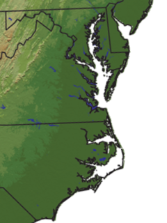
The Chesapeake Bay is an estuary in the U.S. states of Maryland and Virginia. The Bay is located in the Mid-Atlantic region and is primarily separated from the Atlantic Ocean by the Delmarva Peninsula with its mouth of the Bay at the south end located between Cape Henry and Cape Charles. With its northern portion in Maryland and the southern part in Virginia, the Chesapeake Bay is a very important feature for the ecology and economy of those two states, as well as others surrounding within its watershed. More than 150 major rivers and streams flow into the Bay's 64,299-square-mile (166,534 km2) drainage basin, which covers parts of six states and all of Washington, D.C. / District of Columbia.

The Delmarva Peninsula, or simply Delmarva, is a large peninsula on the East Coast of the United States, occupied by the vast majority of the state of Delaware and parts of the Eastern Shore regions of Maryland and Virginia. The peninsula is 170 miles (274 km) long. In width, it ranges from 70 miles (113 km) near its center, to 12 miles (19 km) at the isthmus on its northern edge, to less near its southern tip of Cape Charles. It is bordered by the Chesapeake Bay on the west, and the Delaware River, Delaware Bay, and the Atlantic Ocean on the east.

Somerset County is the southernmost county in the U.S. state of Maryland. As of the 2010 census, the population was 26,470. making it the second-least populous county in Maryland. The county seat is Princess Anne.

Scouting in Maryland has a long history, from the 1910s to the present day, serving millions of youth with activities that have adapted to the changing cultural environment but have always been rooted in an active outdoor program.

Cecil Calvert, 2nd Baron Baltimore, was an English nobleman who was the first Proprietor of the Province of Maryland, ninth Proprietary Governor of the Colony of Newfoundland and second of the colony of Province of Avalon to its southeast. His title was "First Lord Proprietary, Earl Palatine of the Provinces of Maryland and Avalon in America". He received the proprietorship after the death of his father, George Calvert, 1st Baron Baltimore,, for whom it had been intended. Cecil Calvert established and managed the Province of Maryland from his home, Kiplin Hall, in North Yorkshire, England. As an English Roman Catholic, he continued the legacy of his father by promoting religious tolerance in the colony.
Tidewater is a reference to the north Atlantic coastal plain region of the United States of America.

U.S. Route 13 is a north–south U.S. highway established in 1926 that runs for 517 miles (832 km) from Interstate 95 just north of Fayetteville, North Carolina to U.S. Route 1 in the northeastern suburbs of Philadelphia, Pennsylvania, in Morrisville. In all, it traverses five states in the Atlantic coastal plain region. It follows the Atlantic coast more closely than does the main north–south U.S. highway of the region, U.S. Route 1. Its routing is largely rural, the notable exceptions being the Hampton Roads area and the northern end of the highway in Delaware and Pennsylvania. It is also notable for being the main thoroughfare for the Delmarva Peninsula and carrying the Chesapeake Bay Bridge–Tunnel to it in Virginia.
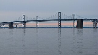
The Chesapeake Bay Bridge is a major dual-span bridge in the U.S. state of Maryland. Spanning the Chesapeake Bay, it connects the state's rural Eastern Shore region with the urban Western Shore. The original span, opened in 1952 and with a length of 4.3 miles (6.9 km), was the world's longest continuous over-water steel structure. The parallel span was added in 1973. The bridge is officially named the Gov. William Preston Lane Jr. Memorial Bridge after William Preston Lane Jr. who, as the 52nd Governor of Maryland, initiated its construction in the late 1940s finally after decades of political indecision and public controversy.

The Eastern Shore of Maryland is a part of the U.S. state of Maryland that lies mostly on the east side of the Chesapeake Bay and consists of nine counties, seven of which have Chesapeake Bay coastlines. The region also contains Maryland's only coast on the Atlantic Ocean. As of the 2010 census, its population was 449,226, with just under 8% of Marylanders living in the region. The term "Eastern Shore" distinguishes a territorial part of the state of Maryland from the Western Shore of Maryland, land west of the Chesapeake Bay. The Eastern Shore is part of the larger Delmarva Peninsula that Maryland shares with Delaware and Virginia.

Southern Maryland in popular usage is composed of the state's southernmost counties on the "Western Shore" of the Chesapeake Bay in the state of Maryland. This region includes all of Calvert, Charles, and St. Mary's counties and sometimes the southern portions of Anne Arundel and Prince George's counties. Despite that the state's southernmost counties are actually on the Delmarva Peninsula, they are not included in most definitions of "Southern Maryland".

Kent Island is the largest island in the Chesapeake Bay and a historic place in Maryland. To the east, a narrow channel known as the Kent Narrows barely separates the island from the Delmarva Peninsula, and on the other side, the island is separated from Sandy Point, an area near Annapolis, by roughly four miles (6.4 km) of water. At only four miles wide, the main waterway of the bay is at its narrowest at this point and is spanned here by the Chesapeake Bay Bridge. The Chester River runs to the north of the island and empties into the Chesapeake Bay at Kent Island's Love Point. To the south of the island lies Eastern Bay. The United States Census Bureau reports that the island has 31.62 square miles (81.90 km2) of land area.
WRYR-LP was a low power radio station licensed to Sherwood, Maryland, United States. It served portions of Anne Arundel, Calvert, Queen Anne, Talbot, Dorchester, and Caroline Counties, including Maryland's capital city of Annapolis. The station was owned by WRYR Community Radio Inc. Its license was cancelled October 2, 2019.
The 2005 Chesapeake Bay crossing study was a study conducted by the state of Maryland in 2005 in order to explore the possibility of building a new crossing of the Chesapeake Bay. The crossing would either be an entirely new crossing that would complement the existing Chesapeake Bay Bridge and Chesapeake Bay Bridge-Tunnel in Virginia or would be an upgrade to the current Maryland crossing.

The Baltimore–Columbia–Towson Metropolitan Statistical Area, also known as Central Maryland, is a Metropolitan Statistical Area (MSA) in Maryland as defined by the United States Office of Management and Budget (OMB). As of the 2010 Census, the combined population of the seven counties is 2,710,489. The MSA has the fourth-highest median household income in the United States, at $66,970 in 2012.

The Calvert Peninsula is part of the Western Shore region of the U.S. state of Maryland. It extends about 25 miles (40 km) into Chesapeake Bay with the main bay providing its eastern border and the Patuxent River defining its western border. It constitutes a total land area of about 350 square miles (910 km2) and is essentially conterminous with Calvert County.
The Broadneck Peninsula is an area in Anne Arundel County, Maryland. The area is north of the Severn River, South of the Magothy River and west of the Chesapeake Bay. At the lower end of the Broadneck Peninsula is the 4.3 mile Chesapeake Bay Bridge.
