Whappstown

Last updated
Whappstown
County
Country Northern Ireland
Sovereign state United Kingdom
Police Northern Ireland
Fire Northern Ireland
Ambulance Northern Ireland
EU Parliament Northern Ireland
List of places
UK
Northern Ireland
Antrim

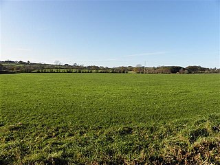
Whappstown is a townland of 634 acres in County Antrim, Northern Ireland. It is situated in the civil parish of Connor and the historic barony of Antrim Lower. [2]

A townland is a small geographical division of land used in Ireland. The townland system is of Gaelic origin, pre-dating the Norman invasion, and most have names of Irish Gaelic origin. However, some townland names and boundaries come from Norman manors, plantation divisions, or later creations of the Ordnance Survey. The total number of inhabited townlands was 60,679 in 1911. The total number recognised by the Irish Place Names database as of 2014 was 61,098, including uninhabited townlands, mainly small islands.

County Antrim Place in Antrim, Northern Ireland

County Antrim is one of six counties that form Northern Ireland. Adjoined to the north-east shore of Lough Neagh, the county covers an area of 3,046 square kilometres (1,176 sq mi) and has a population of about 618,000. County Antrim has a population density of 203 people per square kilometre or 526 people per square mile. It is also one of the thirty-two traditional counties of Ireland, as well as part of the historic province of Ulster.

Northern Ireland Part of the United Kingdom lying in the north-east of the island of Ireland, created 1921

Northern Ireland is a part of the United Kingdom in the north-east of the island of Ireland, variously described as a country, province or region. Northern Ireland shares a border to the south and west with the Republic of Ireland. In 2011, its population was 1,810,863, constituting about 30% of the island's total population and about 3% of the UK's population. Established by the Northern Ireland Act 1998 as part of the Good Friday Agreement, the Northern Ireland Assembly holds responsibility for a range of devolved policy matters, while other areas are reserved for the British government. Northern Ireland co-operates with the Republic of Ireland in some areas, and the Agreement granted the Republic the ability to "put forward views and proposals" with "determined efforts to resolve disagreements between the two governments".

In 1669, James Whap is recorded as living in the townland of Whappstown and the townland name probably derives from his family surname. In William Petty’s c.1672 map from the Down Survey, a version of the original Irish name of the townland is found, recorded as Craginefernon (Creag an Ifearnáin - rock of the place abounding in alders). Whappstown was one of the ‘sixteen towns of Connor’: the sixteen townlands around Connor cathedral which were the property of the bishop of the diocese. [3]

William Petty English scientist, philosopher, statistician and economist

Sir William Petty FRS was an English economist, physician, scientist and philosopher. He first became prominent serving Oliver Cromwell and the Commonwealth in Ireland. He developed efficient methods to survey the land that was to be confiscated and given to Cromwell's soldiers. He also remained a significant figure under King Charles II and King James II, as did many others who had served Cromwell.

Down Survey

The Down Survey was a cadastral survey of Ireland, carried out by English scientist, William Petty, in 1655 and 1656.

See also

Related Research Articles

Tobergill human settlement in United Kingdom

Tobergill is a townland of 1,044 acres in County Antrim, Northern Ireland. Lying on the western aspect of Donegore hill, it is situated in the civil parish of Donegore and the historic barony of Antrim Upper.

Dunadry village in the United Kingdom

Dunadry is a small village and townland 3 miles (5km) from Antrim in County Antrim, Northern Ireland. It is situated in the civil parish of Grange of Nilteen and the historic barony of Antrim Upper. It is within the Borough of Antrim. It had a population of 430 people in the 2011 Census..

Dunamuggy human settlement in United Kingdom

Dunamuggy is a townland of 172 acres in County Antrim, Northern Ireland. It is situated in the civil parish of Donegore and the historic barony of Antrim Upper.

Ballystrudder village in the United Kingdom

Ballystrudder or Ballystruder is a small village and townland on Islandmagee in County Antrim, Northern Ireland. It is situated in the historic barony of Belfast Lower and the civil parish of Islandmagee. It is part of Mid and East Antrim Borough Council. It had a population of 992 people in the 2011 Census.

Lambeg, County Antrim

Lambeg is a small village and civil parish in County Antrim, Northern Ireland. Located between Belfast and Lisburn, it was once a small rural village, but is now within the Greater Belfast conurbation. Lambeg is also an electoral ward of Lisburn Council. In the 2001 Census it had a population of 60 people. The civil parish of Lambeg covers areas of County Down as well as County Antrim.

Solar, County Antrim

Solar is a townland of 42 acres in County Antrim, Northern Ireland. It is situated in the civil parish of Carncastle and the historic barony of Glenarm Upper.

Antrim Lower Place in Northern Ireland, United Kingdom

Antrim Lower is a barony in County Antrim, Northern Ireland. It is bordered by six other baronies: Antrim Upper to the south; Toome Upper to the south-west; Toome Lower to the west; Kilconway to the north-west; Glenarm Lower to the north-east; and Glenarm Upper to the east. The River Braid flows through this barony.

Aughaboy human settlement in United Kingdom

Aughaboy is a townland of 536 acres in County Antrim, Northern Ireland. It is situated in the civil parish of Tickmacrevan and the historic barony of Glenarm Lower. Aughaboy is adjacent to the townland of Deer Park Farms, higher up to the south-east, rising to 1049ft (320m).

Ault, Northern Ireland human settlement in United Kingdom

Ault,, is a townland of 367 acres in County Antrim, Northern Ireland. It is situated in the civil parish of Tickmacrevan and the historic barony of Glenarm Lower.

Ballaghmore is a townland of 163 acres in County Antrim, Northern Ireland. It is situated in the civil parish of Ballymoney and the historic barony of Dunluce Upper.

Unshinagh Mountain is a townland of 635 acres in County Antrim, Northern Ireland. It is situated in the civil parish of Tickmacrevan and the historic barony of Glenarm Lower.

White Mountain is a townland of 484 acres in County Antrim, Northern Ireland, 14.5km south-west of Belfast. It is situated in the civil parish of Derriaghy and the historic barony of Massereene Upper.

Ballybentragh human settlement in United Kingdom

Ballybentragh is a townland of 402 acres in County Antrim, Northern Ireland. It is situated in the civil parish of Grange of Nilteen and the historic barony of Antrim Upper.

Ballyboley is a townland of 294 acres in County Antrim, Northern Ireland. It is situated in the civil parish of Larne and the historic barony of Glenarm Upper.

Ballyclaverty human settlement in United Kingdom

Ballyclaverty is a townland of 339 acres in County Antrim, Northern Ireland. It is situated in the civil parish of Donegore and the historic barony of Antrim Upper.

Ballycollin is a townland of 883 acres in County Antrim, Northern Ireland. It is situated in the civil parish of Derriaghy and the historic Barony of Belfast Upper.

Ballygobbin human settlement in United Kingdom

Ballygobbin is a townland of 172 acres in County Antrim, Northern Ireland. It is situated in the civil parish of Ballymoney and the historic barony of Dunluce Upper.

Ballyboley is a townland of 2,988 acres in County Antrim, Northern Ireland. It is situated in the civil parish of Ballycor and the historic barony of Antrim Upper.

Derriaghy

Derriaghy,, , is a townland and civil parish in County Antrim, Northern Ireland, 5.5 miles (9 km) south-west of Belfast city centre. The townland is situated in the historic barony of Belfast Upper and the civil parish covers areas of both Belfast Upper and the barony of Massereene Upper.

Moyadam is a townland of 685 acres in County Antrim, Northern Ireland. It is situated in the civil parish of Grange of Nilteen and the historic barony of Antrim Upper.

References

  1. The Online Scots Dictionary Retrieved 20 August 2012.
  2. "Whappstown". IreAtlas Townlands Database. Retrieved 20 April 2015.
  3. "Whappstown". Place Names NI. Retrieved 20 April 2015.