Wivenhoe Hill, Queensland

Last updated

Wivenhoe Hill
Queensland
Wivenhoe Hill 2023.jpg
Fig Tree Road, 2023
Australia Queensland location map.svg
Red pog.svg
Wivenhoe Hill
Coordinates 27°21′55″S152°34′04″E / 27.3652°S 152.5677°E / -27.3652; 152.5677
Population9 (2016 census) [1]
 • Density0.54/km2 (1.40/sq mi)
Postcode(s) 4311
Area16.6 km2 (6.4 sq mi)
Time zone AEST (UTC+10:00)
LGA(s) Somerset Region
State electorate(s) Nanango
Federal division(s) Blair
Suburbs around Wivenhoe Hill:
Lake Wivenhoe Lake Wivenhoe Lake Wivenhoe
Coominya Wivenhoe Hill Lake Wivenhoe
Coominya Coominya Patrick Estate

Wivenhoe Hill is a rural locality in the Somerset Region, Queensland, Australia. [2] In the 2016 census, Wivenhoe Hill had a population of 9 people. [1]

Contents

Geography

The locality is beside Lake Wivenhoe, the impoundment created by the Wivenhoe Dam over the Brisbane River. As the name suggests, the locality is hilly with three named peaks: Wivenhoe Hill 188 metres (617 ft), Pine Hill 216 metres (709 ft) and Wash Pool Knoll 84 metres (276 ft). [3] For comparison the shoreline of the lake is 60 to 70 metres (200 to 230 ft) above sea level depending on water levels in the dam. Although the locality is very close to the lake, the shoreline of the lake and the lake itself are within the locality of Lake Wivenhoe. [3]

The Brisbane Valley Highway passes from the very south-east of the locality to the south-west (Coominya). There are only a few roads in the locality; Logan Inlet Road provides access down to the lake shores for camping and recreational use. [3]

The principal land use in the locality is cattle grazing. [3]

History

The locality takes its name from the hill ( 27°22′27″S152°34′41″E / 27.3742°S 152.5780556°E / -27.3742; 152.5780556 (Wivenhoe Hill (Queensland)) ) which in turn was named after a pastoral station operated by Edmund Blucher Uhr circa 1844, [4] which in turn was named after Wivenhoe, a village in Essex, England. [5] The hill is also called Bigges Hill after pastoralist and politician Francis Edward Bigge who operated the Mount Brisbane pastoral run in the district. [5]

The Wivenhoe pastoral station was historically beside the Brisbane River, but after the construction of Wivenhoe Dam across the river (opened 1984), the locality is now adjacent to Lake Wivenhoe. [3]

Attractions

The Logan Inlet day-use area offers swimming, boating, fishing and picnic facilities. There are two campsites: Captain Logan camp ground and Lumley Hill camp ground. [6]

Education

There are no school in Wivenhoe Hill. There are primary schools in neighbouring Coominya and Patrick Estate. The nearest secondary school is in Lowood 19 kilometres (12 mi) away. [3]

Related Research Articles

<span class="mw-page-title-main">Brisbane Valley Highway</span>

The Brisbane Valley Highway is a state highway in Queensland, Australia. It links the Warrego Highway near Ipswich and the D'Aguilar Highway about 4 km (2 mi) north of Harlin. Its direction follows the approximate course of the Brisbane River. It is part of State Route A17, which is duplexed with the D'Aguilar Highway to Nanango and then becomes the Burnett Highway. State Route 85 is duplexed with the Brisbane Valley Highway from Esk to the D'Aguilar Highway.

Lake Wivenhoe is the name both an artificial lake formed by the Wivenhoe Dam and the locality which contains it in the Somerset Region, Queensland, Australia. In the 2016 census, Lake Wivenhoe had a population of three people.

<span class="mw-page-title-main">Somerset Dam</span> Dam in South East Queensland

The Somerset Dam is a mass concrete gravity dam with a gated spillway across the Stanley River in Queensland, Australia. It is within the locality of Somerset Dam in the Somerset Region in South East Queensland. The main purpose of the dam is the supply of potable water for the Brisbane, Gold Coast and Logan City regions. Additionally, the dam provides for flood mitigation, recreation and for the generation of hydroelectricity. The impounded reservoir is called Lake Somerset.

<span class="mw-page-title-main">Wivenhoe Dam</span> Dam in South East Queensland

The Wivenhoe Dam is a rock and earth-fill embankment dam with a concrete spillway across the Brisbane River in South East Queensland, Australia. The dam takes it names from the local Wivenhoe Pocket rural community. The dam wall is located about 80 kilometres (50 mi) by road from the centre of Brisbane. The primary purpose of the dam is the supply of potable water for the Brisbane and Ipswich regions. The dam also provides for flood mitigation control, hydroelectricity, and recreation. The impounded reservoir is called Lake Wivenhoe and the dam, the lake and a narrow strip of surrounding land forms a locality also called Lake Wivenhoe.

<span class="mw-page-title-main">Coominya, Queensland</span> Town in Queensland, Australia

Coominya is a rural town and locality in the Somerset Region in South East Queensland, Australia. The town is located 83 kilometres (52 mi) west of the state capital, Brisbane and approximately 2 kilometres (1.2 mi) from Wivenhoe Dam. In the 2016 census, Coominya had a population of 1,200 people.

<span class="mw-page-title-main">Fernvale, Queensland</span> Town in Queensland, Australia

Fernvale is a rural town and locality in the Somerset Region, Queensland, Australia. In the 2016 census, the locality of Fernvale had a population of 3,209 people.
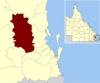
<span class="mw-page-title-main">Somerset Region</span> Local government area in Queensland, Australia

The Somerset Region is a local government area located in the West Moreton region of South East Queensland, Australia, about 100 kilometres (62 mi) northwest of Brisbane and centred on the town of Esk. It was created in 2008 from a merger of the Shire of Esk and the Shire of Kilcoy. It is commonly known as the Brisbane Valley, due to the Brisbane River which courses through the region, although significant parts of the region lie outside the hydrological Brisbane Valley itself.

<span class="mw-page-title-main">Bellevue Homestead</span> Historic homestead in Coominya, Queensland, Australia

Bellevue Homestead is a heritage-listed homestead currently located in Coominya, Somerset Region, Queensland, Australia. It was built from c. 1872 to c. 1910. It was added to the Queensland Heritage Register on 21 October 1992.

<span class="mw-page-title-main">Wivenhoe Pocket</span> Suburb of Somerset Region, Queensland, Australia

Wivenhoe Pocket is a rural locality in the Somerset Region, Queensland, Australia. In the 2016 census, Wivenhoe Pocket had a population of 440 people.

<span class="mw-page-title-main">Coominya railway station</span> Railway station in Queensland, Australia

Coominya railway station is central to all activities in historic Coominya village, located in the Somerset Region of South East Queensland.

<span class="mw-page-title-main">Dundas, Queensland</span> Suburb of Somerset Region, Queensland, Australia

Dundas is a rural locality in the Somerset Region, Queensland, Australia. In the 2016 census Dundas had a population of 77 people.

<span class="mw-page-title-main">Crossdale, Queensland</span> Suburb of Somerset Region, Queensland, Australia

Crossdale is a rural locality in the Somerset Region, Queensland, Australia. In the 2016 census, Crossdale had a population of 75 people.

<span class="mw-page-title-main">Hazeldean, Queensland</span> Suburb of Somerset Region, Queensland, Australia

Hazeldean is a rural locality in the Somerset Region, Queensland, Australia. In the 2016 census, Hazeldean had a population of 262 people.

Coal Creek is a rural locality in the Somerset Region, Queensland, Australia. In the 2021 census, Coal Creek had a population of 50 people.

Mount Stanley is a rural locality in the Somerset Region, Queensland, Australia. In the 2016 census Mount Stanley had a population of 7 people.

Moombra is a rural locality in the Somerset Region, Queensland, Australia. In the 2021 census, Moombra had a population of 9 people.

Glen Esk is a locality in the Somerset Region, Queensland, Australia. In the 2021 census, Glen Esk had a population of 55 people.

Caboonbah is a rural locality in the Somerset Region, Queensland, Australia. In the 2016 census, Caboonbah had a population of 14 people.

<span class="mw-page-title-main">Biarra, Queensland</span> Suburb of Somerset Region, Queensland, Australia

Biarra is a rural locality in the Somerset Region, Queensland, Australia. In the 2021 census, Biarra had a population of 270 people.

Mount Hallen is a rural locality in the Somerset Region, Queensland, Australia. In the 2021 census, Mount Hallen had a population of 457 people.

References

  1. 1 2 Australian Bureau of Statistics (27 June 2017). "Wivenhoe Hill (SSC)". 2016 Census QuickStats. Retrieved 20 October 2018. OOjs UI icon edit-ltr-progressive.svg
  2. "Wivenhoe Hill – locality in Somerset Region (entry 44932)". Queensland Place Names. Queensland Government . Retrieved 11 June 2019.
  3. 1 2 3 4 5 6 "Queensland Globe". State of Queensland . Retrieved 11 June 2019.
  4. "DEATH OF THE LATE SERGEANTAT-ARMS". Warwick Argus And Tenterfield Chronicle . Vol. X, no. 36. Queensland, Australia. 23 July 1874. p. 2. Retrieved 16 June 2019 via National Library of Australia.
  5. 1 2 "Wivenhoe Hill – Hill in Somerset Region (entry 37790)". Queensland Place Names. Queensland Government . Retrieved 16 June 2019.
  6. "Visit Lake Wivenhoe" (PDF). Seqwater. December 2017. Archived (PDF) from the original on 15 June 2019. Retrieved 16 June 2019.