Çal

Last updated • 3 min readFrom Wikipedia, The Free Encyclopedia
Çal
Denizli location Cal.png
Map showing Çal District in Denizli Province
Turkey adm location map.svg
Red pog.svg
Çal
Location in Turkey
Aegean Region.svg
Red pog.svg
Çal
Çal (Turkey Aegean)
Coordinates: 38°5′1″N29°23′56″E / 38.08361°N 29.39889°E / 38.08361; 29.39889
Country Turkey
Province Denizli
Government
  MayorAhmet Hakan (CHP)
Area
860 km2 (330 sq mi)
Population
 (2022) [1]
17,889
  Density21/km2 (54/sq mi)
Time zone UTC+3 (TRT)
Area code 0258
Website cal.bel.tr

Çal (Turkish: [tʃaɫ] ) is a municipality and district of Denizli Province, Turkey. [2] Its area is 860 km2, [3] and its population is 17,889 (2022). [1] Çal district area occupies a central position in the northern part of its province and neighbors the district of Pamukkale to the south-west and the district areas of Güney to the west and Honaz to the south. To the east of Çal district lies clockwise the districts of Bekilli, Çivril and Baklan.

Contents

The town of Çal is located 64 km (40 mi) north-east of the provincial seat of Denizli and is situated on a rocky hilltop overlooking a plain traced by Büyük Menderes River. The town lies at an altitude of 850 m (2,790 ft).

General features

Roman remains have been found in the area. Hançalar Bridge over Menderes River, at the level of the township of the same name, situated between Çal and Bekilli, is reminiscent of Roman bridges by its style, while the builder remains unknown. It was repaired and restored several times during the Ottoman era. The first Turks in the area were the Seljuk Turks in 1072, who settled in all parts of the present-day Denizli Province, including Çal.

The area is largely agricultural and is known especially for its vineyards. The local grape variety Çalkarası and grown intensively and takes its name from the district. Çal also has an annual wine festival. There is also a cement factory, a fruit-juice factory and various cold-stores for fruit.

Composition

There are 34 neighbourhoods in Çal District: [4]

Sakızcılar Falls and the "Weeping Stone"

A notable sight of interest are the waterfalls near the depending village of Sakızcılar, on the slopes of the Mount Çal (Çaldağı) and at a distance of about 40 km (25 mi) when coming from Pamukkale. Water of a stream that later joins Menderes River fall from 50 meters high at this locality and the whole area is covered with forests, making it a notable natural site. It is also a large trout farm. The falls are alternatively called "Yeşildere Falls" or "Ağlayan Kaya" (the weeping stone). [5]

Notable natives

The people of Çal acquired a fame for their astuteness and alertness in the region. They are hard-working and stubborn, and also raised crafty horsethieves in the past. There is an old regional saying that goes, if you put a snake in a sack with a man from Çal, the snake will beg to be taken out.

The renowned painter İbrahim Çallı was born here, as his name indicates.

The award-winning author and poet Mahmut Alptekin is from Çal. He was born there and spent some of his childhood in Çal.

The award-winning academic, psychiatrist and author Dr. Erol Göka is from Çal.

The award-winning author and poet Hasan Ali Toptaş is from Çal.

See also

Related Research Articles

<span class="mw-page-title-main">Denizli Province</span> Province of Turkey

Denizli Province is a province and metropolitan municipality of Turkey in Western Anatolia, on high ground above the Aegean coast. Neighbouring provinces are Uşak to the north, Burdur, Isparta, Afyon to the east, Aydın, Manisa to the west and Muğla to the south. It is located between the coordinates 28° 30’ and 29° 30’ E and 37° 12’ and 38° 12’ N. Its area is 12,134 km2, and its population is 1,056,332 (2022). The provincial capital is the city of Denizli.

<span class="mw-page-title-main">Denizli</span> City in Aegean Region, Turkey

Denizli is a city in Aegean Turkey, and seat of the province of Denizli. The city forms the urban part of the districts Merkezefendi and Pamukkale, with a population of 651,200 in 2022.

<span class="mw-page-title-main">Aydın Province</span> Province of Turkey

Aydın Province is a province and metropolitan municipality of southwestern Turkey, located in the Aegean Region. Its area is 8,116 km2, and its population is 1,148,241 (2022). The provincial capital is the city of Aydın. Other towns in the province include the summer seaside resorts of Didim and Kuşadası.

<span class="mw-page-title-main">Nazilli</span> District and municipality in Aydın, Turkey

Nazilli is municipality and district of Aydın Province, Turkey. Its area is 691 km2, and its population is 162,737 (2022). It is the second-largest city in Aydın Province, after the city of Aydın. It is 47 km (29 mi) east of Aydın, on the road to Denizli.

<span class="mw-page-title-main">Karahallı</span> Municipality in Uşak, Turkey

Karahallı is a town in Uşak Province in the inner Aegean region of Turkey. It is the seat of Karahallı District. Its population is 5,672 (2022). Karahallı is at a distance of 62 km (39 mi) from the province center of Uşak lying to its north.

<span class="mw-page-title-main">Kuyucak</span> District and municipality in Aydın, Turkey

Kuyucak is a municipality and district of Aydın Province, Turkey. Its area is 544 km2, and its population is 26,111 (2022). It is 58 km (36 mi) from the city of Aydın on the E24 highway that connects İzmir and Denizli, 180 km (112 mi) east of İzmir. Kuyucak is near the larger town of Nazilli.

<span class="mw-page-title-main">Çivril</span> District and municipality in Denizli, Turkey

Çivril is a municipality and district of Denizli Province, Turkey. Its area is 1,570 km2, and its population is 59,967 (2022). Çivril district area neighbors those of two districts of Uşak Province to its north, namely Sivaslı and Karahallı, and four districts of Afyonkarahisar Province from the north-east to the south which are, clockwise, Sandıklı, Dinar, Dazkırı and Dazkırı, and to its south-west, three districts of the same province as itself depending Denizli. These last three are Bekilli, Çal and Baklan.

<span class="mw-page-title-main">Güney</span> District and municipality in Denizli, Turkey

Güney is a municipality and district of Denizli Province, Turkey. Its area is 362 km2, and its population is 9,448 (2022). Güney district area neighbors those of four other districts of the same province from east to west, clockwise Buldan, Pamukkale and Çal and ranges Eşme district of Uşak Province in the north.

<span class="mw-page-title-main">Sarayköy</span> District and municipality in Denizli, Turkey

Sarayköy is a municipality and district of Denizli Province, Turkey. Its area is 379 km2, and its population is 30,834 (2022). It is 20 km west of the city of Denizli, on a plain between mountains and watered by Büyük Menderes River.

<span class="mw-page-title-main">Serinhisar</span> District and municipality in Denizli, Turkey

Serinhisar is a municipality and district of Denizli Province, Turkey. Its area is 256 km2, and its population is 14,355 (2022).

<span class="mw-page-title-main">Sultanhisar</span> District and municipality in Aydın, Turkey

Sultanhisar is a municipality and district of Aydın Province, Turkey. Its area is 220 km2, and its population is 20,230 (2022). It is 30 km east of the city of Aydın on the road to Denizli.

<span class="mw-page-title-main">Buharkent</span> District and municipality in Aydın, Turkey

Buharkent is a municipality and district of Aydın Province, Turkey. Its area is 124 km2, and its population is 13,022 (2022). It is 86 km east of the city of Aydın, on the road and the railway line to Denizli.

<span class="mw-page-title-main">Acıpayam</span> District and municipality in Denizli, Turkey

Acıpayam is a municipality and district of Denizli Province, Turkey. Its area is 1,772 km2, and its population is 54,888 (2022). It lies in high country between the Aegean and Mediterranean regions. A plain, watered by two reservoirs, known for growing melons and watermelons, on the road between the city of Denizli and Antalya. Its altitude is 895 m.

<span class="mw-page-title-main">Baklan</span> District and municipality in Denizli, Turkey

Baklan is a municipality and district of Denizli Province, Turkey. Its area is 283 km2, and its population is 5,296 (2022). The town is at a distance of about an hour from the city of Denizli, neighboring the town of Çivril, and it is situated on the road to Ankara.

<span class="mw-page-title-main">Bekilli</span> District and municipality in Denizli, Turkey

Bekilli is a municipality and district of Denizli Province, Turkey. Its area is 304 km2, and its population is 6,424 (2022). Bekilli district area neighbors the district areas of Çal and Çivril, both also depending Denizli to the west, south and east, and those of two districts of Uşak Province to the north, namely Ulubey and Karahallı.

<span class="mw-page-title-main">Kepez, Antalya</span> District of Antalya, Turkey

Kepez is a municipality and district of Antalya Province, Turkey. Its area is 292 km2, and its population is 608,675 (2022).

<span class="mw-page-title-main">Merkezefendi</span> District and municipality in Denizli, Turkey

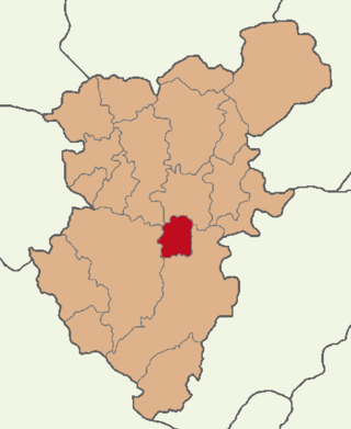
Merkezefendi is a municipality and district of Denizli Province, Turkey. Its area is 336 km2, and its population is 336,818 (2022). The district was established as a result of the 2013 local government reorganisation from part of the former central district of Denizli. Another part of the former central district was added to the Pamukkale District. The name of the district refers to the 16th-century Sufi Merkez Efendi.

<span class="mw-page-title-main">Pamukkale, Denizli</span> District and municipality in Denizli, Turkey

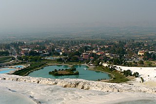
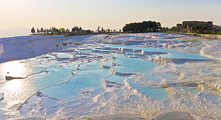
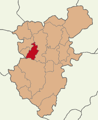
Pamukkale, formerly known as Akköy, is a municipality and district of Denizli Province, Turkey. Its area is 823 km2, and its population is 347,926 (2022).

<span class="mw-page-title-main">Karahallı District</span> District of Uşak Province, Turkey

Karahallı District is a district of the Uşak Province of Turkey. Its seat is the town of Karahallı. Its area is 330 km2, and its population is 9,664 (2022). Karahallı district area neighbors those of two other districts of the same province to the north, namely Ulubey District and Sivaslı District, and to the south those of two districts depending Denizli Province which are Çivril and Bekilli. The district area is crossed by Banaz Stream and is divided roughly equally between agricultural lands and woodland, mostly oaks.

References

  1. 1 2 "Address-based population registration system (ADNKS) results dated 31 December 2022, Favorite Reports" (XLS). TÜİK . Retrieved 12 July 2023.
  2. Büyükşehir İlçe Belediyesi, Turkey Civil Administration Departments Inventory. Retrieved 12 July 2023.
  3. "İl ve İlçe Yüz ölçümleri". General Directorate of Mapping. Retrieved 12 July 2023.
  4. Mahalle, Turkey Civil Administration Departments Inventory. Retrieved 12 July 2023.
  5. Not to be confused with the famous rock of the same name in Mount Sipylus in Manisa and associated with Niobe.