This article needs additional citations for verification .(December 2009) |
Wikimedia Commons has media related to Ü-Tsang .
Look up Ü-Tsang in Wiktionary, the free dictionary.
- ↑ Goldstein, Melvyn (1997). The Snow Lion and the Dragon: China, Tibet, and the Dalai Lama . Berkeley: U of California. ISBN 9780520212541.
- ↑ Annand, Dibyesh (February 2009). "Strategic Hypocrisy: The British Imperial Scripting of Tibet's Geopolitical Identity" (PDF). The Journal of Asian Studies. 68: 227–252. doi:10.1017/s0021911809000011 – via WestminsterResearch.
- ↑ Goldstein, Melvyn C. (2007). A history of modern Tibet, Volume 2: The Calm before the Storm: 1951–1955. University of California Press. pp. 217. ISBN 978-0-520-24941-7.
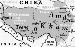
| Ü-Tsang | |||||||||
|---|---|---|---|---|---|---|---|---|---|
| Chinese name | |||||||||
| Traditional Chinese | 烏思藏 | ||||||||
| Simplified Chinese | 乌思藏 | ||||||||
| |||||||||
| |||||||||