
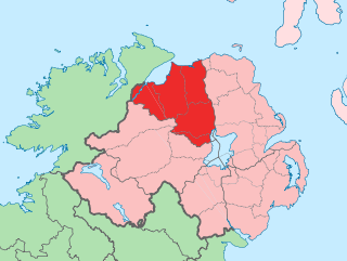
County Antrim is one of six counties of Northern Ireland and one of the thirty-two counties of Ireland. Adjoined to the north-east shore of Lough Neagh, the county covers an area of 3,086 square kilometres (1,192 sq mi) and has a population of about 618,000. County Antrim has a population density of 203 people per square kilometre or 526 people per square mile. It is also one of the thirty-two traditional counties of Ireland, as well as part of the historic province of Ulster.
County Londonderry, also known as County Derry, is one of the six counties of Northern Ireland, one of the thirty two counties of Ireland and one of the nine counties of Ulster. Before the partition of Ireland, it was one of the counties of the Kingdom of Ireland from 1613 onward and then of the United Kingdom after the Acts of Union 1800. Adjoining the north-west shore of Lough Neagh, the county covers an area of 2,118 km2 (818 sq mi) and today has a population of about 247,132.

Carrickfergus is a large town in County Antrim, Northern Ireland. It sits on the north shore of Belfast Lough, 11 miles (18 km) from Belfast. The town had a population of 27,998 at the 2011 Census. It is County Antrim's oldest town and one of the oldest towns in Ireland as a whole. Carrickfergus Castle, built in the late 12th century at the behest of Anglo-Norman knight John de Courcy, was the capital of the Earldom of Ulster. After the earldom's collapse, it remained the only English outpost in Ulster for the next four centuries. Carrickfergus was the administrative centre for Carrickfergus Borough Council, before this was amalgamated into the Mid and East Antrim District Council in 2015, and forms part of the Belfast Metropolitan Area. It is also a townland of 65 acres, a civil parish and a barony.

Larne is a town on the east coast of County Antrim, Northern Ireland, with a population of 18,755 at the 2011 Census. It is a major passenger and freight roll-on roll-off port. Larne is administered by Mid and East Antrim Borough Council. Together with parts of the neighbouring districts of Antrim and Newtownabbey and Causeway Coast and Glens, it forms the East Antrim constituency for elections to the Westminster Parliament and Northern Ireland Assembly. The civil parish is in the historic barony of Glenarm Upper.

Newtownabbey is a large settlement north of Belfast city centre in County Antrim, Northern Ireland. It is separated from the rest of the city by Cavehill and Fortwilliam golf course. It surrounds Carnmoney Hill, and was formed from the merging of several small villages including Whiteabbey, Glengormley and Carnmoney. At the 2011 Census, Metropolitan Newtownabbey Settlement had a population of 65,646, making it the third largest settlement in Northern Ireland. It is part of Antrim and Newtownabbey Borough Council.

Ballymena is a town in County Antrim, Northern Ireland. It had a population of 29,551 people at the 2011 Census, making it the eighth largest town in Northern Ireland by population. It is part of the Borough of Mid and East Antrim.

Antrim is a town and civil parish in County Antrim in the northeast of Northern Ireland, on the banks of the Six Mile Water, on the northeast shore of Lough Neagh. It had a population of 23,375 people in the 2011 Census. It is the county town of County Antrim and was the administrative centre of Antrim Borough Council. It is 22 miles (35 km) northwest of Belfast.
Donegore is the name of a hill, a townland, a small cluster of residences, and a civil parish in the historic barony of Antrim Upper, County Antrim, Northern Ireland. Donegore lies approximately 5 miles (8 km) east of Antrim town. 154 acres of the townland lies in the civil parish of Grange of Nilteen.

Tobergill is a townland of 1,044 acres in County Antrim, Northern Ireland. Lying on the western aspect of Donegore hill, it is situated in the civil parish of Donegore and the historic barony of Antrim Upper.

Ballycraigy is a townland and housing estate in Antrim town, Northern Ireland. According to the census for Ballycraigy ward the estate has approximately 865 residents.

Whiteabbey is a townland in Newtownabbey, north of Belfast in County Antrim, Northern Ireland.
Monkstown is a townland and electoral ward in County Antrim, Northern Ireland. It is within the urban area of Newtownabbey and the Antrim and Newtownabbey Borough Council area. The townland was previously called Ballynamanagh It is also situated in the civil parish of Carnmoney and the historic barony of Belfast Lower.
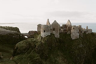
Dunluce Castle is a now-ruined medieval castle in Northern Ireland, the seat of Clan MacDonnell. It is located on the edge of a basalt outcropping in County Antrim, and is accessible via a bridge connecting it to the mainland. The castle is surrounded by extremely steep drops on either side, which may have been an important factor to the early Christians and Vikings who were drawn to this place where an early Irish fort once stood.
Toome or Toomebridge is a small village and townland on the northwest corner of Lough Neagh in County Antrim, Northern Ireland. It lies in the civil parish of Duneane in the former barony of Toome Upper, and is in the Antrim and Newtownabbey Borough Council area. It had a population of 781 in the 2011 census.

Straid is a small village in County Antrim, Northern Ireland, about three miles east of Ballyclare, and about six miles inland from Carrickfergus. It lies at the centre of the townland of Straidlands, in the Civil Parish of Ballynure within the Antrim and Newtownabbey Borough Council area, and in the former barony of Belfast Lower. The village has a congregational church, an Orange hall, and a primary school.
Jordanstown is a townland and electoral ward in County Antrim, Northern Ireland. It is within the urban area of Newtownabbey and the Antrim and Newtownabbey Borough Council area. It is also situated in the civil parish of Carnmoney and the historic barony of Belfast Lower. It had a population of 6,225 in the 2011 census, with an average age of 40.

Randalstown is a townland and small town in County Antrim, Northern Ireland, between Antrim and Toome. It has a very prominent disused railway viaduct and lies beside Lough Neagh and the Shane's Castle estate. The town is bypassed by the M22 motorway with junctions at both the eastern and western ends of the town. It had a population of 5,126 people in the 2011 Census.

Carrickfergus is a barony in County Antrim, Northern Ireland. It is bounded on the south-east by Belfast Lough, and otherwise surrounded by the barony of Belfast Lower. It is coextensive with the civil parish of Carrickfergus or St Nicholas and corresponds to the former county of the town of Carrickfergus, a county corporate encompassing Carrickfergus town.
White Hall, Northern Ireland or Gortamaddy is a townland in County Antrim, Northern Ireland.

Ballygill North is a townland in County Antrim, Northern Ireland. It is located in the northwestern part of Rathlin Island and has an area of 149 acres (60 ha). It contains Skerriagh, the northernmost point of Northern Ireland.

