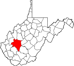
Amandaville, West Virginia

Last updated
Amandaville, West Virginia
USA West Virginia location map.svg
Red pog.svg
Amandaville
Location in West Virginia and the United States
Usa edcp location map.svg
Red pog.svg
Amandaville
Amandaville (the United States)
Coordinates: 38°23′50″N81°51′21″W / 38.39722°N 81.85583°W / 38.39722; -81.85583 Coordinates: 38°23′50″N81°51′21″W / 38.39722°N 81.85583°W / 38.39722; -81.85583
Country United States
State West Virginia
County Kanawha
Elevation
604 ft (184 m)
Time zone UTC-5 (Eastern (EST))
  Summer (DST) UTC-4 (EDT)
GNIS ID 1534912 [1]

Amandaville is an unincorporated community in Kanawha County, West Virginia, United States.

Related Research Articles

Ohio River Major river in the midwestern United States

The Ohio River is a 981-mile (1,579 km) long river in the United States. It is located in the Midwestern and Southern United States, flowing southwesterly from western Pennsylvania south of Lake Erie to its mouth on the Mississippi River at the southern tip of Illinois. It is the third largest river by discharge volume in the United States and the largest tributary by volume of the north-south flowing Mississippi River that divides the eastern from western United States. The river flows through or along the border of six states, and its drainage basin includes parts of 14 states. Through its largest tributary, the Tennessee River, the basin includes several states of the southeastern U.S. It is the source of drinking water for three million people.

West Virginia State of the United States of America

West Virginia is a state in the Appalachian, Mid-Atlantic and Southeastern regions of the United States. It is bordered by Pennsylvania to the northeast, Maryland to the east and northeast, Virginia to the southeast, Kentucky to the southwest, and Ohio to the northwest. West Virginia is the 41st-largest state by area and ranks 38th in population, with a population of 1,795,045 residents. The capital and largest city is Charleston.

Charleston, West Virginia Capital of West Virginia

Charleston is the capital and most populous city of the U.S. state of West Virginia. Located at the confluence of the Elk and Kanawha rivers, the city had a population of 51,400 at the 2010 census and an estimated population of 46,536 in 2019. The Charleston metropolitan area as a whole had an estimated 208,089 residents in 2019. Charleston is the center of government, commerce, and industry for Kanawha County, of which it is the county seat.

Kanawha County, West Virginia U.S. county in West Virginia

Kanawha County is a county in the U.S. state of West Virginia. As of the 2019 American Community Survey, the population was 183,279. This was a decrease of 9,784 since the 2010 Census; nevertheless, it is West Virginia's most populous county. The county seat is Charleston, which is also the state capital. Kanawha County is part of the Charleston, WV Metropolitan Statistical Area.

Morgantown, West Virginia City in West Virginia, United States

Morgantown is the county seat of Monongalia County, West Virginia, United States, situated along the Monongahela River. West Virginia University is located in the city. The population was 29,660 at the 2010 Census Bureau, making Morgantown the largest city in North-Central West Virginia. The Morgantown metropolitan area has a population of 138,176.

Wheeling, West Virginia City in West Virginia, United States

Wheeling is a city in Ohio and Marshall counties in the U.S. state of West Virginia. Located almost entirely in Ohio County, of which it is the county seat, it lies along the Ohio River in the foothills of the Appalachian Mountains. Wheeling was originally a settlement in the British colony of Virginia, and later the second largest city in the Commonwealth of Virginia. Wheeling was where creation of West Virginia was planned, and it was the first capital of the new state. Due to its location along major transportation routes, including the Ohio River, National Road, and the B&O Railroad, Wheeling became a manufacturing center in the late nineteenth century. After experiencing the closing of factories and substantial population loss following World War II, Wheeling's major industries now include healthcare, education, law and legal services, entertainment and tourism, and energy.

West Virginia University Public university in West Virginia, U.S.

West Virginia University (WVU) is a public, land-grant, research university with its main campus in Morgantown, West Virginia. Its other campuses are those of the West Virginia University Institute of Technology in Beckley, Potomac State College of West Virginia University in Keyser, and a second clinical campus for the university's medical and dental schools at Charleston Area Medical Center in Charleston. WVU Extension Service provides outreach with offices in all of West Virginia's 55 counties.

National Register of Historic Places listings in West Virginia

This is a list of properties and historic districts in West Virginia that are listed on the National Register of Historic Places. There are listings in every one of West Virginia's 55 counties.

West Virginia in the American Civil War Origin of West Virginia; during the U.S. Civil War

The U.S. state of West Virginia was formed out of western Virginia and added to the Union as a direct result of the American Civil War, in which it became the only modern state to have declared its independence from the Confederacy. In the summer of 1861, Union troops, which included a number of newly-formed Western Virginia regiments, under General George McClellan, drove off Confederate troops under General Robert E. Lee. This essentially freed Unionists in the northwestern counties of Virginia to form a functioning government of their own as a result of the Wheeling Convention. Prior to the admission of West Virginia the government in Wheeling formally claimed jurisdiction over all of Virginia, although from its creation it was firmly committed to the formation of a separate state.

U.S. Route 60 in West Virginia

U.S. Route 60 (US 60) runs northwest to southeast across the central and southern portions of West Virginia. It runs from the Kentucky state line at Catlettsburg, Kentucky and Kenova. The road passes through the limits of the cities and towns of Kenova, Ceredo, Huntington, Barboursville, Milton, Hurricane, St. Albans, South Charleston, Charleston, Belle, Cedar Grove, Glasgow, Smithers, Gauley Bridge, Ansted, Rainelle, Rupert, Lewisburg, and White Sulphur Springs, as well as in or near the smaller communities of Ona, Culloden, Amandaville, Jefferson, Malden, Rand, Dupont City, Diamond, Shrewsbury, Hugheston, London, Boomer, Falls View, Charlton Heights, Glen Ferris, Chimney Corner, Victor, Hico, Lookout, Hilton Village, Charmco, Hines, Crawley, Sam Black Church, Clintonville, Alta, and Caldwell. The route exits the state into Virginia concurrent with Interstate 64 east of White Sulphur Springs. Most of US 60's route through West Virginia is part of and even signed in several areas as the Midland Trail.

West Virginia Mountaineers football American college football team

The West Virginia Mountaineers football team represents West Virginia University in the NCAA Football Bowl Subdivision (FBS) of college football. West Virginia plays its home games on Mountaineer Field at Milan Puskar Stadium on the campus of West Virginia University in Morgantown, West Virginia. The Mountaineers have won or shared a total of 15 conference championships, including eight Southern Conference titles and seven Big East Conference titles. The Mountaineers compete in the Big 12 Conference and are led by head coach Neal Brown.

The Huntington–Ashland metropolitan area is a metropolitan area in the Appalachian Plateau region of the United States. Referred to locally as the “Tri-State area”, the region spans seven counties in the three states of West Virginia, Kentucky, and Ohio. With a population of 361,580, the Tri-State area is nestled along the banks of the Ohio River. The region offers a diverse range of outdoor activities.

Amandaville, Kentucky Unincorporated community in Kentucky, United States

Amandaville is an unincorporated community in Cumberland County, Kentucky, United States. It lies along Route 704 north-northeast of the city of Burkesville, the county seat of Cumberland County. Its elevation is 600 feet (183 m).

Amandaville may refer to:

COVID-19 pandemic in West Virginia COVID-19 pandemic in West Virginia, United States

The U.S. state of West Virginia reported its first confirmed case relating to the COVID-19 pandemic on March 17, 2020, becoming the last state to do so. However, the particular patient had been showing symptoms for several days prior. On March 29, 2020, the state reported its first COVID-19 death.

Randolph Bowe American baseball player

Randolph Bowe, nicknamed "Lefty" and "Bob", was an American Negro league pitcher from 1938 to 1940.

References