"},"population_total":{"wt":"9964"},"population_as_of":{"wt":"2022"},"postal_code":{"wt":"44800"},"area_code":{"wt":"0422"},"website":{"wt":"{{url|http://www.arapgir.bel.tr/}}"}},"i":0}}]}" id="mwAg">District and municipality in Malatya, Turkey
Arapgir | |
---|---|
District and municipality | |
![]() Map showing Arapgir District in Malatya Province | |
Coordinates: 39°02′N38°29′E / 39.033°N 38.483°E | |
Country | Turkey |
Province | Malatya |
Government | |
• Mayor | Haluk Cömertoğlu (CHP) |
Area | 987 km2 (381 sq mi) |
Population (2022) [1] | 9,964 |
• Density | 10/km2 (26/sq mi) |
Time zone | UTC+3 (TRT) |
Postal code | 44800 |
Area code | 0422 |
Website | www |
Arapgir (Armenian : Արաբկիր; Kurdish : Erebgir [2] ) is a municipality and district of Malatya Province, Turkey. [3] Its area is 987 km2, [4] and its population is 9,964 (2022). [1]
It is situated at the confluence of the eastern and western Euphrates, but some miles from the right bank of the combined streams. Arapgir is connected with Sivas by a chaussée, prolonged to the Euphrates river. The present town was built in the mid-19th century, but about 2 miles north-east is the old town, now called Eskişehir ("old city" in Turkish). [5]
This territory is a part of historical Lesser Armenia. The old town of Arapgir was founded by the Armenian King Senekerim-Hovhannes Artsruni in 1021, who had exchanged his kingdom of Vaspurakan for estates in the central lands of the Byzantine Empire. [6]
There are 63 neighbourhoods in Arapgir District: [7]
Arapgir has a dry-summer humid continental climate (Köppen: Dsa), transitioning to a Mediterranean climate (Köppen: Csa) [8] with hot, dry summers and cold, frequently snowy winters. [9]
Climate data for Arapgir (1991–2020) | |||||||||||||
---|---|---|---|---|---|---|---|---|---|---|---|---|---|
Month | Jan | Feb | Mar | Apr | May | Jun | Jul | Aug | Sep | Oct | Nov | Dec | Year |
Mean daily maximum °C (°F) | 2.7 (36.9) | 4.4 (39.9) | 10.1 (50.2) | 16.3 (61.3) | 21.7 (71.1) | 27.7 (81.9) | 32.4 (90.3) | 33.0 (91.4) | 28.1 (82.6) | 20.8 (69.4) | 11.9 (53.4) | 5.0 (41.0) | 17.9 (64.2) |
Daily mean °C (°F) | −0.8 (30.6) | 0.4 (32.7) | 5.4 (41.7) | 11.0 (51.8) | 16.1 (61.0) | 21.6 (70.9) | 25.7 (78.3) | 26.2 (79.2) | 21.6 (70.9) | 15.0 (59.0) | 7.2 (45.0) | 1.4 (34.5) | 12.6 (54.7) |
Mean daily minimum °C (°F) | −3.4 (25.9) | −2.5 (27.5) | 1.8 (35.2) | 6.7 (44.1) | 11.3 (52.3) | 16.2 (61.2) | 20.1 (68.2) | 20.7 (69.3) | 16.2 (61.2) | 10.5 (50.9) | 3.7 (38.7) | −1.2 (29.8) | 8.4 (47.1) |
Average precipitation mm (inches) | 100.67 (3.96) | 86.87 (3.42) | 79.16 (3.12) | 80.47 (3.17) | 66.4 (2.61) | 16.8 (0.66) | 3.18 (0.13) | 2.13 (0.08) | 13.08 (0.51) | 49.2 (1.94) | 75.21 (2.96) | 97.59 (3.84) | 670.76 (26.41) |
Average precipitation days (≥ 1.0 mm) | 9.6 | 8.7 | 9.1 | 9.4 | 9.0 | 3.4 | 2.0 | 1.8 | 2.6 | 5.8 | 6.8 | 9.6 | 77.8 |
Average relative humidity (%) | 69.2 | 65.2 | 56.5 | 51.8 | 48.5 | 37.1 | 30.7 | 29.9 | 33.5 | 48.3 | 58.3 | 70.7 | 50.0 |
Source: NOAA [10] |
Arapgir town is populated by Kurds. [11] In descending order of population, the district is populated by Turks, Kurds, and Armenians. Armenians used to be the second largest ethnic group after Turks, constituting one third of the population, but most of the population was wiped out during the Armenian genocide. [12]
Ethnic composition of the villages in Arapgir District:
According to Donald Quataert, Arapgir in the 1880s was made up of 4,802 Muslim and 1,200 Armenian households, with a total population of about 29,000 persons. [23] According to a METU study citing Nejat Göyünç, the city population was about 20,000 in 1911, of which more than half of the population was Armenian Christians and the rest were Muslim. [24] [25] Differing sources present differing pictures for the respective shares of ethnicities within the weavers' community. The Armenian population is reported to have suffered severely during the Hamidian massacres of 1895, [26] although, in this regard, Donald Quataert notes, with textile exports back to normal levels a year after the turmoil, in 1896, either all weavers were Muslims after all, or few Armenian weavers were killed, displaced or disrupted during the troubles.
On the eve of World War I, there were about 9,523 Armenians (1,300 houses) and 6,774 Turks living in Arapgir. [27] After the 1915 Armenian genocide, most of the Armenian population of Arapgir was killed or deported. [28]
Before the Armenian genocide Arapgir had seven Armenian Apostolic churches: Surp Astvadzadzin (Holy Mother of God) Church, not to be confused with the cathedral, Grigor Lusavorich (Gregory the Illuminator) Church, Surp Kevork Church, Surp Hagob Church, Surp Nshan Church, Surp Pilibos Arakel (St. Philip the Apostle) Church, Surp Sarkis Church, There were, also, one Catholic Surp Prgich (Holy Saviors) Church and one Protestant Cuğran Church. [29] There were also more than 10 schools in the town. Little is left of pre-war Arapgir, but there are still some old houses that have survived, which are Armenian origin. The town also contains the ruins of a castle, several Seljuk mosques, [5] old cemetery and silver mines.
The Armenian genocide was the systematic destruction of the Armenian people and identity in the Ottoman Empire during World War I. Spearheaded by the ruling Committee of Union and Progress (CUP), it was implemented primarily through the mass murder of around one million Armenians during death marches to the Syrian Desert and the forced Islamization of others, primarily women and children.
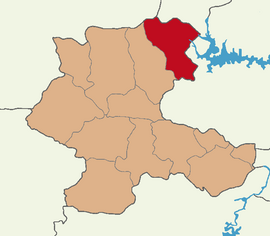
Erzincan, historically Yerznka, is the capital of Erzincan Province in eastern Turkey. Nearby cities include Erzurum, Sivas, Tunceli, Bingöl, Elazığ, Malatya, Gümüşhane, Bayburt, and Giresun. The city is majority Sunni Turkish with an Alevi Kurdish minority.
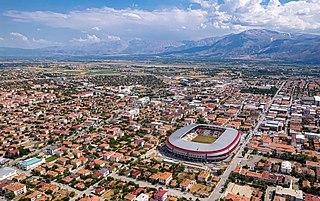
Sivas is a city in central Turkey. It is the seat of Sivas Province and Sivas District. Its population is 365,274 (2022).
The Sayfo, also known as the Seyfo or the Assyrian genocide, was the mass murder and deportation of Assyrian/Syriac Christians in southeastern Anatolia and Persia's Azerbaijan province by Ottoman forces and some Kurdish tribes during World War I.
The Ottoman Armenian population varied throughout history. The number of Armenians within the empire between 1914 and 1915 is a controversial topic. Most estimates by Western scholars range from 1.5 to 2.4 million. According to Britannica prior to 1915 and Samuel Cox, American Embassy in Istanbul from 1880-1886, it was 1.75 million and 2.4 million, respectively.
Mardin is a city and seat of the Artuklu District of Mardin Province in Turkey. It is known for the Artuqid architecture of its old city, and for its strategic location on a rocky hill near the Tigris River.
Kadirli, historically Kars or Karsbazar, is a city in Osmaniye Province in the Mediterranean region of Turkey. It is the seat of Kadirli District. Its population is 98,469 (2022). It is located in the Çukurova plain, 41 kilometres from the province's capital, Osmaniye. It is located near the ancient site of Flaviopolis.
Hertevin, officially Ekindüzü, is a village in the Pervari District of Siirt Province in Turkey.
Muş is a city in eastern Turkey. It is the seat of Muş Province and Muş District. Its population is 120,699 (2022). Almost all of its population consists of Kurds.
Sason is a town in the Batman Province of Turkey. It is the seat of the Sason District. Its population is 12,696 (2021). It was formerly known as Kabilcevz.
Kozluk is a town and seat of Kozluk District in Batman Province, Turkey. The town had a population of 27,825 in 2021. The mayor is Mehmet Veysi Işık (AKP).
Çemişgezek is a municipality (belde) and seat of Çemişgezek District of Tunceli Province, Turkey. The mayor is Levent Metin Yıldız (AKP).
Çermik is a municipality and district of Diyarbakır Province, Turkey. Its area is 948 km2, and its population is 49,644 (2022). The mayor is Şehmus Karamehmetoğlu from the Justice and Development Party (AKP), and the current kaymakam is Vahit Yılmaz.
Çatak is a municipality and district of Van Province, Turkey. Its area is 1,952 km2, and its population is 18,462 (2022). As mayor Abdurrahman Şeylan from the Justice and Development Party (AKP) was elected in the local elections in March 2019, Sercan Sakarya is the current Kaymakam, installed in August 2022.
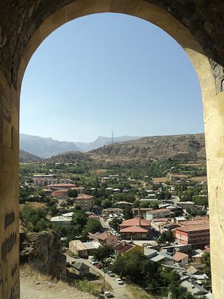
Kemah, known historically as Ani-Kamakh, Gamakh, Kamacha or Kamachon is a town in Erzincan Province in the Eastern Anatolia Region of Turkey. It is the seat of Kemah District. Its population is 2,929 (2022). The town is located almost in the centre of Erzincan Province.
Arabkir, is one of the 12 districts of Yerevan, the capital of Armenia. Located to the north of the city centre, Arabkir is bordered by the Davtashen District from the northwest, Ajapnyak District from the west, Kentron District from the south, and Kanaker-Zeytun District from the east. Hrazdan River forms the natural border of the district from the north and the west. At the north, Arabkir has common borders with the community of Kanakeravan of Kotayk Province.
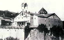
The Monastery of Saint Minas is a former Armenian monastery in eastern Turkey. It's a dome-less basilica with columns. Located at the western edge of Gezköy village of Erzurum province in Turkey now. The village of Gezköy is about 9 km west of the centre of the city of Erzurum.
Raymond Haroutioun Kévorkian is a French Armenian historian. He is a Foreign Member of Armenian National Academy of Sciences. Kevorkian has a PhD in history (1980), and is a professor.
The eastern part of the current territory of the Republic of Turkey is part of the ancestral homeland of the Armenians. Along with the Armenian population, during and after the Armenian genocide the Armenian cultural heritage was targeted for destruction by the Ottoman government. Of the several thousand churches and monasteries in the Ottoman Empire in 1914, today only a few hundred are still standing in some form; most of these are in danger of collapse. Those that continue to function are mainly in Istanbul.
{{cite journal}}
: Cite journal requires |journal=
(help)