Ashokan Center

Last updated

Ashokan Field Campus Historic District
WigglyBridge.jpg
The Wiggly Bridge
USA New York location map.svg
Red pog.svg
Location within New York state
Usa edcp location map.svg
Red pog.svg
Ashokan Center (the United States)
Location Olive Bridge, New York
Coordinates 41°55′46″N74°12′8″W / 41.92944°N 74.20222°W / 41.92944; -74.20222
Area385 acres (156 ha)
Built18th century-1967
Website www.ashokancenter.org
NRHP reference No. 100003622
Added to NRHP16 April 2019

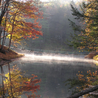
The Ashokan Center (formerly the Ashokan Field Campus, listed on the National Register of Historic Places (NRHP) as the Ashokan Field Campus Historic District, [1] is a 385 acre outdoor education, conference, and retreat center located in the Catskill Mountains of New York. Schools have explored and been inspired by Ashokan's forests, waterfalls, stream-fed ponds, and open meadows since 1967. Music camps, blacksmithing conferences, and retreat groups have called Ashokan home while schools are not in residence. The name Ashokan means "place of many fishes," or "where rushing waters meet" in the Lenape language.[ citation needed ]

Contents

The location was the inspiration for Jay Ungar's song "Ashokan Farewell", which was used as the theme music for PBS's The Civil War . [2] In 2019 it was listed on the NRHP. [1]

History

The first homesteaders on the land were a third generation Dutchman named Jacobus Bush and his wife, Eycke Vandermerke, born in Marbletown, Ulster County, New York in 1692 and 1687 respectively. Jacobus Jr. and his wife Annetje Merkel recorded their ownership on a deed of remembrance in 1732. In 1755, his brother Thomas and his wife's sister Elizabeth built a homestead a few hundred yards up the road. This is the house from which his son Fredrick's children were kidnapped by Tory inspired "Indians". Thomas was an outspoken proponent of the patriot cause. This was the frontier during the American Revolutionary War and it was a common practice for Tories and their Indian allies to raid frontier homes. It had become such a problem that General Washington authorized the building of a fort at Shokan, now under the waters of the Ashokan Reservoir.

The property was owned and operated by SUNY New Paltz's College Auxiliary Service as the Ashokan Field Campus from 1967 until 2008. [3]

The land was sold in 2008 to the Open Space Conservancy, part of the Open Space Institute. The property was divided with a portion sold to the New York City Department of Environmental Protection and the rest to the non-profit Ashokan Foundation. [4] The Ashokan Foundation continues to support and develop environmental education programs for schools in partnership with non-profit partner the Ashokan Center. Additionally Ashokan's Music & Dance Camps for adults and families have remained in continuous operation since 1980 and additional new arts programs are currently in the works.

Geology

The story of Ashokan begins over 400 million years ago during the Devonian Period. The vastly swollen Esopus Creek struggled to find its present path through Ashokan which was well-blocked by glacial moraine. Winchell's Falls and Cathedral Gorge are relatively recent (past ten-thousand years) features. The newly uncovered till (glacial soil) was rocky and sterile, and much like northern Canada today. It was covered by tundra where feeding mammoths and other ice age mammals migrated along the un-crossable Esopus. As the climate continued to warm, the open landscape gave way to spruce and fir of the boreal forest. Mastodons and woodland caribou took over the trail blazing begun by earlier mammals. At some point during this time, the first people entered the area hunting the ice-age "mega-fauna". Evidence of these first people is scant in this area, but they undoubtedly followed the game trails along the Esopus.

See also

Related Research Articles

<span class="mw-page-title-main">Ellenville, New York</span> Village in New York, United States

Ellenville is a village within the town of Wawarsing, Ulster County, New York, United States. Its population was 4,167 at the 2020 census.

<span class="mw-page-title-main">Esopus, New York</span> Town in New York, United States

Esopus is a town in Ulster County, New York, United States. The population was 9,548 at the 2020 census. The town was named after the local indigenous tribe and means "small river" in English. They were one of the Lenape (Delaware) bands, belonging to a people who ranged from western Connecticut through lower New York, western Long Island, and parts of New Jersey and Pennsylvania along the Delaware River. The town is on the west bank of the Hudson River south of the city of Kingston. Its center is in Port Ewen. US Route 9W passes along the eastern side of the town.

<span class="mw-page-title-main">Catskill Mountains</span> Mountains in southeastern New York State, U.S.

The Catskill Mountains, also known as the Catskills, are a physiographic province and subrange of the larger Appalachian Mountains, located in southeastern New York. As a cultural and geographic region, the Catskills are generally defined as those areas close to or within the borders of the Catskill Park, a 700,000-acre (2,800 km2) forest preserve protected from many forms of development under New York state law.

<span class="mw-page-title-main">Perrine's Bridge</span> Bridge

Perrine's Bridge is the second oldest covered bridge in the State of New York, after the Hyde Hall Bridge in East Springfield. Once located in the hamlet called Perrines Bridge between 1850 and 1861. It is located in the modern day town of Esopus-Rosendale, New York just a few hundred feet to the east of Interstate 87 crossing of the Wallkill River in Ulster County, New York. Originally built to aid in the movement of trade between the towns of Rifton and Rosendale, the bridge is about 90 miles north of New York city between mile markers 81 and 82 on the New York State Thruway. In May 1834 the State of New York authorized and provided money ($700) to Ulster county, NY, to build the bridge. In 1835, the bridge was built by Benjamin Wood, the one-lane wooden covered bridge has been closed to vehicular traffic since 1930. The Bridge derives its name from James W. Perrine, a descendant of Daniel Perrin "The Huguenot", who was a tavern keeper that opened an inn on the east side of that future bridge in 1820. Perrine's son was hired each winter as the "snower". He would spread snow the length of the structure so horse-drawn sleighs could cross.

<span class="mw-page-title-main">Ashokan Reservoir</span> New York City reservoir in Catskill Mountains

The Ashokan Reservoir is a reservoir in Ulster County, New York. It is at the eastern end of the Catskill Park, and is one of several in the region created to provide the City of New York with water. It is the city's deepest reservoir at 190 feet (58 m) near the dam at the former site of Bishop Falls.

<span class="mw-page-title-main">Esopus Creek</span> Tributary of the Hudson River in the Catskill region of New York state

Esopus Creek is a 65.4-mile-long (105.3 km) tributary of the Hudson River that drains the east-central Catskill Mountains in the U.S. state of New York. From its source at Winnisook Lake on the slopes of Slide Mountain, the Catskills' highest peak, it flows across Ulster County to the Hudson at Saugerties. Many tributaries extend its watershed into neighboring Greene County and a small portion of Delaware County. Midway along its length, it is impounded at Olive Bridge to create Ashokan Reservoir, the first of several built in the Catskills as part of New York City's water supply system. Its own flow is supplemented 13 miles (21 km) above the reservoir by the Shandaken Tunnel, which carries water from the city's Schoharie Reservoir into the creek.

<span class="mw-page-title-main">Brown's Station, New York</span> Village in United States of America

Brown's Station was a hamlet in the Esopus Valley of southeastern Ulster County, New York, United States. It was submerged by the waters of the Ashokan Reservoir, an artificial lake built between 1906 and 1915 to supply fresh water to New York City.

<span class="mw-page-title-main">Esopus Meadows Light</span> Lighthouse

Esopus Meadows Lighthouse, nicknamed "Maid of the Meadows" and often simply referred to as the Esopus Light or Middle Hudson River Light is an active lighthouse on the Hudson River near Esopus, New York. The lighthouse stands on the west side of the channel, in the river, its granite foundation built atop piles that have been driven into the riverbed, and is accessible only by boat.

Snyder's Regiment of Militia was known officially as The First Regiment of Ulster County Militia. It was the first regiment of four created in Ulster County, New York as ordered by the Provincial Congress of New York. It was also referred to as the Northern Regiment since its members were from the Northern section of Ulster County towns including Kingston, New York and Saugerties, New York

<span class="mw-page-title-main">John Jay Homestead State Historic Site</span> United States historic place

The John Jay Homestead State Historic Site is located at 400 Jay Street in Katonah, New York. The site preserves the 1787 home of Founding Father and statesman John Jay (1745–1829), one of the three authors of The Federalist Papers and the first Chief Justice of the United States. The property was designated a National Historic Landmark in 1981 for its association with Jay. The house is open year-round for tours.

<span class="mw-page-title-main">Ashokan Bridge</span> United States historic place

Ashokan Bridge is a wooden covered bridge over Esopus Creek on the grounds of the Ashokan Center, in Ulster County. It was built in 1885, and is a single span, gable roofed, covered timber bridge. It measures 72 feet, 6 inches, long and 16 feet, 4 inches, wide. It was originally located at Turnwood and moved to its present location in 1939. It is situated in the Ashokan Center, which was formerly the Ashokan Field Campus of the State University of New York at New Paltz.

<span class="mw-page-title-main">Readington Village, New Jersey</span> Populated place in Hunterdon County, New Jersey, US

Readington Village is an unincorporated community located within Readington Township in Hunterdon County, in the U.S. state of New Jersey, that is centered on the converging of Readington Road, Hillcrest Road, Centerville Road and Brookview Road. It is located on Holland Brook, originally named Amanmechunk, which means large creek in the Unami dialect. The area was inhabited by the Raritan prior to the arrival of European settlers. The Native Americans who lived near Readington Village travelled to the coast during the summer for fish and clams. Such a trip is mentioned in an Indian deed transferring lands around Holland Brook to George Willocks, an East and West New Jersey Proprietor. The deed mentions two of the natives, who lived at Readington: Metamisco and Wataminian.

<span class="mw-page-title-main">Reformed Protestant Dutch Church of Klyne Esopus</span> Historic church in New York, United States

Reformed Protestant Dutch Church of Klyne Esopus, now known as Klyne Esopus Historical Society Museum, is a historic Dutch Reformed church building at 764 US 9W in Esopus, Ulster County, New York.

<span class="mw-page-title-main">Col. Oliver Hazard Payne Estate</span> Historic house in New York, United States

Col. Oliver Hazard Payne Estate is a historic 60-acre (24 ha) estate, also known as Omega and Wiltwick, located on the west bank of the Hudson River at Esopus in Ulster County, New York, United States. The estate features a 42,000-square-foot (3,900 m2) Beaux Arts-style Mediterranean palazzo with an open courtyard. It was designed in 1905 for Col. Oliver Hazard Payne by the architect Thomas Hastings of the firm of Carrère and Hastings, who also designed the New York Public Library and the Henry Clay Frick House. The estate is currently owned by Marist College and operated as the Raymond A. Rich Institute for Leadership Development.

Payne House may refer to:

<span class="mw-page-title-main">Hurley, New York</span> Town in New York, United States

Hurley is a town in Ulster County, New York, United States. The population was 6,178 at the 2020 census. The town is in the northeastern part of the county, west of the city of Kingston. Much of the town is inside the Catskill Park. Located within the town is a hamlet and census-designated place, also named Hurley. The Town of Hurley comprises the hamlets of Hurley, West Hurley and Glenford.

<span class="mw-page-title-main">Kingston, New York</span> County seat of Ulster County, New York, US

Kingston is the only city in, and the county seat of, Ulster County, New York, United States. It is 91 miles (146 km) north of New York City and 59 miles (95 km) south of Albany. The city's metropolitan area is grouped with the New York metropolitan area around Manhattan by the United States Census Bureau. The population was 24,069 at the 2020 United States Census.

<span class="mw-page-title-main">Saugerties, New York</span> Town in Ulster County, New York, United States

Saugerties is a town in the northeastern corner of Ulster County, New York. The population was 19,038 at the time of the 2020 Census, a decline from 19,482 in 2010. The village of the same name is located entirely within the town.

<span class="mw-page-title-main">Woodstock, New York</span> Town in New York, United States

Woodstock is a town in Ulster County, New York, United States, in the northern part of the county, northwest of Kingston. It lies within the borders of the Catskill Park. The population was 6,287 at the 2020 census, up from 5,884 in 2010.

<span class="mw-page-title-main">Marlboro Mountains</span> Mountain in the United States

The Marlboro Mountains, sometimes Marlborough Mountains, are a group of hogbacked mountains arranged in a 25-mile-long (40 km) ridge extending from Newburgh, New York, to just south of Kingston, New York. Considered to be part of the Ridge and Valley Appalachians, the mountains, which reach elevations over 1,100 feet, form an imposing geologic barrier just west of the Hudson River. They subdivide the relatively flat Hudson River Valley to create the Wallkill Valley further west. Rising abruptly on their eastern flanks, the Marlboro Mountains are known for their sweeping views of the region.

References

  1. 1 2 "National Register of Historic Places listings for April 26, 2019". U.S. National Park Service. 19 April 2019. Retrieved 27 April 2019.
  2. "The Music of The Civil War" . Retrieved 4 July 2011..
  3. "About Ashokan". Ashokan Center. Archived from the original on 25 July 2011. Retrieved 4 July 2011.
  4. "Historic Signing of Agreement for Sale of Ashokan Field Campus Announced". New York City. Retrieved 4 July 2011.