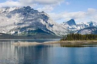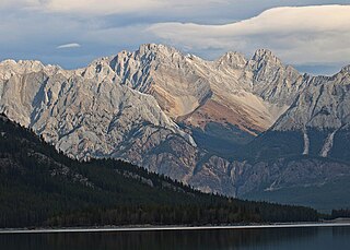
Mount Galatea is the highest peak of the Kananaskis Range, a subrange of the Canadian Rockies in the province of Alberta. It is located in the upper Spray Lakes Valley of the Kananaskis Country system of provincial parks. The mountain was named after the Royal Navy cruiser HMS Galatea.

Bow Valley Provincial Park is a provincial park in Alberta, Canada. Established in 1959 in the arch of the Bow River at its confluence with the Kananaskis River, the park is one park of many within the Kananaskis Country park system.

Peter Lougheed Provincial Park is in Kananaskis Country about 90 kilometres (56 mi) west of Calgary, along the Kananaskis Trail in Alberta, Canada.

The Palliser Range is a mountain range of the Canadian Rockies that lies in the extreme southeast corner of Banff National Park, Alberta, Canada.

Sheep River Provincial Park is a provincial park located in Alberta, Canada, 23 kilometres (14 mi) west of Diamond Valley on highway 546. It is part of the Kananaskis Country park system and encompasses a portion of the Sheep River valley.

Mount Tyrwhitt is a mountain in British Columbia and Alberta, Canada, located between Highway 40 and Elk Pass in the Elk Range of the Canadian Rockies, west of the Highwood Pass parking lot in Kananaskis Country and south east of Upper Kananaskis Lake. Located on the Continental Divide, it is also therefore on the border between British Columbia and Alberta, which follows the Divide in this area.

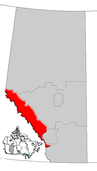
Alberta's Rockies comprise the Canadian Rocky Mountains in Alberta, Canada. On the southwestern part of the province along the British Columbia border, the region covers all but the south of Census Division 15.

Mount Engadine is a 2,972-metre (9,751-foot) mountain summit located in the Spray River Valley of Kananaskis Country, in the Canadian Rockies of Alberta, Canada. It was named in 1917 after HMS Engadine, a seaplane tender of the Royal Navy present at the Battle of Jutland during World War I. The mountain is located in the Kananaskis Range in Alberta.

Highwood Pass is a mountain pass in Kananaskis Country, Alberta, Canada. It lies west of Mount Rae and Mount Arethusa of the Misty Range, south of Elbow Pass. It lies within the Peter Lougheed Provincial Park on Alberta Highway 40. The Highwood River originates in the pass.

The Front Ranges are a group of mountain ranges in the Canadian Rockies of eastern British Columbia and western Alberta, Canada. It is lowest and the easternmost of the three main subranges of the Continental Ranges, located east of the Bull and Elk rivers and a fault line extending northwest of West Elk Pass to McGregor Pass.

Mount Black Prince is a 2,939-metre (9,642-foot) mountain summit located in Peter Lougheed Provincial Park in the Canadian Rockies of Alberta, Canada. Its nearest higher peak is Mount Smith Dorrien, 5.8 km (3.6 mi) to the northwest. The mountain can be seen from Highway 742, also known as Smith-Dorrien/Spray Trail.

Mount Kidd is a 2,958-metre (9,705-foot) double-summit massif centrally located in Kananaskis Country in the Canadian Rockies of Alberta, Canada. Mount Kidd is situated within Spray Valley Provincial Park, and its nearest higher neighbor is Mount Sparrowhawk, 7.0 km (4.3 mi) to the northwest. Mount Kidd is a landmark that can be seen from Highway 40 in the Kananaskis Village area, and from the Kananaskis Country Golf Course which lies at the eastern base of the mountain.

Mount Jerram is a 2,996-metre (9,829-foot) mountain summit located in the Opal Range of the Canadian Rockies of Alberta, Canada. Its nearest higher peak is Elpoca Mountain, 4.0 km (2.5 mi) to the south-southeast. Mount Jerram is situated east of Mount Wintour, within Peter Lougheed Provincial Park.

Gap Mountain is a 2,675-metre (8,776-foot) mountain summit located at the southern end of the Opal Range in the Canadian Rockies of Alberta, Canada. The nearest higher neighbor is Elpoca Mountain, 2 km (1.2 mi) to the east. Gap Mountain is situated 5 km (3.1 mi) south of Mount Wintour, within Peter Lougheed Provincial Park. Gap Mountain is a conspicuous peak seen from Alberta Highway 40 at Highwood Pass. It is a popular climbing destination because it offers exposed scrambling on its eastern flanks with excellent summit views of Kananaskis Country.

Mount French is a 3,244-metre (10,643-foot) summit in the Spray Mountains range of the Canadian Rockies in Alberta, Canada. The mountain is situated in Peter Lougheed Provincial Park of Kananaskis Country. French is the second highest point in the Spray Mountains Range. Its nearest higher peak, and highest in the Spray Range, is Mount Sir Douglas, 3.0 km (1.9 mi) to the west. Mount French can be seen from Alberta Highway 742, the Smith-Dorrien/Spray Trail.

Mount Indefatigable is a 2,667-metre (8,750-foot) mountain summit located in Peter Lougheed Provincial Park in the Canadian Rockies of Alberta, Canada. The peak is visible from Alberta Highway 40, and the Kananaskis Lakes area. Mount Indefatigable's nearest higher neighbour is Mount Invincible, 1.8 km (1.1 mi) to the northwest.

Mount Packenham is a 3,000-metre (9,800-foot) mountain summit located in the Opal Range of the Canadian Rockies of Alberta, Canada. Its nearest higher peak is Mount Evan-Thomas, 1.0 km (0.62 mi) to the north. Situated on the eastern boundary of Peter Lougheed Provincial Park, the peak is visible from Highway 40 and the Kananaskis Lakes area.

Fisher Peak is a 3,053-metre (10,016-foot) mountain summit located in the Fisher Range of Kananaskis Country in the Canadian Rockies of Alberta, Canada. Fisher Peak is the highest point in the Fisher Range, so its nearest higher peak is Mount Evan-Thomas, 7.0 km (4.3 mi) to the southwest in the Opal Range. Precipitation runoff from the mountain drains west into Evan-Thomas Creek, which is a tributary of the Kananaskis River, or east into the Little Elbow River which is a tributary of the Elbow River.
Don Getty Wildland Provincial Park is a wildland provincial park in Kananaskis Country, Alberta, Canada. It was created on 24 July 2001 and has an area of 62,775 hectares. The park was named for the 11th premier of Alberta, Don Getty. The park was designated as part of the Special Places 2000: Alberta’s Natural Heritage initiative.


