Cicero, Indiana | |
---|---|
Cicero | |
Coordinates: 40°07′39″N86°01′23″W / 40.12750°N 86.02306°W | |
Country | United States |
State | Indiana |
County | Hamilton |
Township | Jackson |
Area | |
• Total | 2.04 sq mi (5.29 km2) |
• Land | 1.63 sq mi (4.22 km2) |
• Water | 0.41 sq mi (1.07 km2) |
Elevation | 810 ft (250 m) |
Population (2020) | |
• Total | 5,301 |
• Density | 3,254.14/sq mi (1,256.60/km2) |
Time zone | UTC-5 (EST) |
• Summer (DST) | UTC-5 (EST) |
ZIP code | 46034 |
Area code | 317 |
FIPS code | 18-12628 [3] |
GNIS feature ID | 2396646 [2] |
Website | http://www.ciceroin.org |
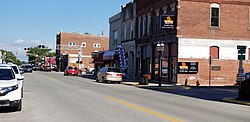
Cicero is a town in Jackson Township, Hamilton County, Indiana, United States, north of Indianapolis. The population was 4,812 at the 2010 census.
Cicero is notable for welcoming teenaged AIDS activist Ryan White to its community in 1987. [4] White is buried in Cicero.
Cicero was founded in 1835. [5] The town took its name from Cicero Creek. [6] The first post office in Jackson Township was established at Cicero in 1839. [7]
The construction of Morse Reservoir in 1956, the northern end of which lies in Cicero, brought more development to the town as well. [8]
Cicero is located on the northeast shore of Morse Reservoir.
According to the 2010 census, Cicero has a total area of 2.12 square miles (5.49 km2), of which 1.71 square miles (4.43 km2) (or 80.66%) is land and 0.41 square miles (1.06 km2) (or 19.34%) is water. [9]
Census | Pop. | Note | %± |
---|---|---|---|
1860 | 278 | — | |
1870 | 422 | 51.8% | |
1880 | 715 | 69.4% | |
1890 | 631 | −11.7% | |
1900 | 1,603 | 154.0% | |
1910 | 990 | −38.2% | |
1920 | 906 | −8.5% | |
1930 | 933 | 3.0% | |
1940 | 943 | 1.1% | |
1950 | 1,021 | 8.3% | |
1960 | 1,284 | 25.8% | |
1970 | 1,378 | 7.3% | |
1980 | 2,557 | 85.6% | |
1990 | 3,268 | 27.8% | |
2000 | 4,303 | 31.7% | |
2010 | 4,812 | 11.8% | |
2020 | 5,301 | 10.2% | |
U.S. Decennial Census [10] |
Cicero is largely a lakeside community.
As of the census [11] of 2010, there were 4,812 people, 1,952 households, and 1,381 families living in the town. The population density was 2,814.0 inhabitants per square mile (1,086.5/km2). There were 2,167 housing units at an average density of 1,267.3 per square mile (489.3/km2). The racial makeup of the town was 96.8% White, 0.6% African American, 0.6% Native American, 0.5% Asian, 0.4% from other races, and 1.1% from two or more races. Hispanic or Latino of any race were 1.5% of the population.
There were 1,952 households, of which 34.8% had children under the age of 18 living with them, 53.6% were married couples living together, 11.3% had a female householder with no husband present, 5.8% had a male householder with no wife present, and 29.3% were non-families. 24.5% of all households were made up of individuals, and 8.2% had someone living alone who was 65 years of age or older. The average household size was 2.47 and the average family size was 2.89.
The median age in the town was 39.8 years. 25.2% of residents were under the age of 18; 6.6% were between the ages of 18 and 24; 25.6% were from 25 to 44; 31% were from 45 to 64; and 11.6% were 65 years of age or older. The gender makeup of the town was 49.2% male and 50.8% female.
As of the census [3] of 2000, there were 4,303 people, 1,716 households, and 1,257 families living in the town. The population density was 2,877.8 inhabitants per square mile (1,111.1/km2). There were 1,811 housing units at an average density of 1,211.2 per square mile (467.6/km2). The racial makeup of the town was 97.89% White, 0.19% African American, 0.30% Native American, 0.28% Asian, 0.02% Pacific Islander, 0.63% from other races, and 0.70% from two or more races. Hispanic or Latino of any race were 1.12% of the population.
There were 1,716 households, out of which 36.0% had children living with them, 59.2% were married couples living together, 10.0% had a female householder with no husband present, and 26.7% were non-families. 21.4% of all households were made up of individuals, and 6.5% had someone living alone who was 65 years of age or older. The average household size was 2.51 and the average family size was 2.92.
In the town, the population was spread out, with 26.4% under the age of 18, 8.2% from 18 to 24, 32.3% from 25 to 44, 24.6% from 45 to 64, and 8.5% who were 65 years of age or older. The median age was 36 years. For every 100 females, there were 96.2 males. For every 100 females age 18 and over, there were 96.0 males.
The median income for a household in the town was $54,561, and the median income for a family was $60,559. Males had a median income of $39,131 versus $29,574 for females. The per capita income for the town was $23,169. About 0.7% of families and 1.7% of the population were below the poverty line, including none of those under age 18 and 2.8% of those age 65 or over.
Cicero is served by Hamilton Heights School Corporation, Indiana Academy [12] and Cicero Seventh-day Adventist Elementary School. [13]
The town has a lending library, the Hamilton North Public Library. [14]
The plot of the episode entitled "The Kids Are All Right" from the TV series Supernatural took place in the town of Cicero, Indiana. However, it does not accurately depict the town, much to the disappointment of certain fans.
Cicero Seventh-day Adventist Church [15] is the home of the Hope for Life television ministry, with Pastors Aaron Clark and Vic Van Schaik. [16]
The town was represented in the 1989 biopic The Ryan White Story as the town to which Ryan White moved order to escape prejudice in Kokomo, Indiana. [17] However, it is only featured in the last two scenes of the movie.
Odon is a town in Madison Township, Daviess County, Indiana, United States. The population was 1,354 at the 2010 census.
Westport is a town located in Sand Creek Township, Decatur County, Indiana. The population was 1,379 at the 2010 census. A covered bridge, built in 1880, is located about 1.5 miles east of town.
Hamilton is a town located on the border of Steuben County, Indiana and DeKalb County, Indiana. In Steuben County, it is in Otsego Township, and in DeKalb County it is in Franklin Township. The population was 1,532 at the 2010 census.
Atlanta is a town in Jackson Township, Hamilton County, Indiana, United States. The population was 725 at the 2010 census.
Wilkinson is a town in Brown Township, Hancock County, Indiana, United States. The population was 449 at the 2010 census.
Wheatfield is a town in Wheatfield Township, Jasper County, Indiana, United States. The population was 904 at the 2020 census.
Ingalls is a town in Green Township, Madison County, Indiana, United States. It is part of the Indianapolis–Carmel–Anderson metropolitan statistical area. The population was 2,223 at the 2020 census.
Crane is a town in Perry Township, Martin County, in the U.S. state of Indiana. The population was 166 at the 2020 census. The community is adjacent to the Naval Surface Warfare Center Crane Division.
Bunker Hill is a town in Pipe Creek Township, Miami County, in the U.S. state of Indiana. The population was 814 at the 2020 census, down from 888 in 2010.
Bethany is a town in Clay Township, Morgan County, in the U.S. state of Indiana. The population was 95 at the 2020 census.
Paragon is a town in Ray Township, Morgan County, in the U.S. state of Indiana. The population was 556 at the 2020 census, down from 659 in 2010.
Spurgeon is a town in Monroe Township, Pike County, in the U.S. state of Indiana. The population was 207 at the 2010 census. It is part of the Jasper Micropolitan Statistical Area.
Town of Pines is a town in Pine Township, Porter County, in the U.S. state of Indiana. The population was 594 as of the 2020 census.
Sunman is a town in Adams Township, Ripley County, in the U.S. state of Indiana. The population was 1,049 at the 2010 census.
North Liberty is a town in Liberty Township, St. Joseph County, in the U.S. state of Indiana. The population was 1,896 at the 2010 Census. North Liberty is part of the South Bend–Mishawaka, IN-MI, Metropolitan Statistical Area.
Shadeland is a town in Union Township, Tippecanoe County, in the U.S. state of Indiana. The population was 1,610 at the 2010 census.
Elberfeld is a town in Greer Township, Warrick County, in the U.S. state of Indiana. The population was 625 as of the 2010 census.
Cicero is a town in Outagamie County, Wisconsin, United States. The population was 1,092 at the 2000 census.
Crows Nest is a town in Washington Township, Marion County, Indiana, United States, approximately 7 miles (11 km) north of downtown Indianapolis. The population was 67 at the 2020 census. It has existed as an "included town" since 1970, when it was incorporated into Indianapolis as part of Unigov. It is part of Indianapolis, but retains a functioning town government under IC 36-3-1-11.
Homecroft is a town in Perry Township, Marion County, Indiana, United States. The population was 752 at the 2020 census. Incorporated in 1949, it has existed as an included town since 1970, when it was incorporated into Indianapolis as part of Unigov. It is part of Indianapolis, but retains a functioning town government under IC 36-3-1-11.