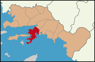
Datça is a municipality and district of Muğla Province, Turkey.[2] Its area is 436km2,[3] and its population is 25,029 (2022).[1] The town center is situated midway through the peninsula which carries the same name as the district and the town (Datça Peninsula). It was a nahiya of Marmaris District until 1928. Datça's first center in village of Reşadiye till 1947, when it was moved to present borough of İskele.
The name Datça comes from Stadia, an ancient town near Cnidus. Stadia developed into Tadya, Dadya, Dadça, and then Datça.[4]
Both the town and the peninsula of Datça were called Reşadiye[5] for a brief period in the beginning of the 20th century, honoring the penultimate Ottoman Sultan Mehmed V Reşad, and some maps may still refer to the peninsula under this name; today Reşadiye is the name of one of the quarters of the town.
Geography
The long and narrow Datça Peninsula, whose outline follows the undulations of small bays and coves facing south or north all along its length which reaches near 100km (62mi), corresponds almost exactly to the Datça district, with the addition beyond its isthmus of a small panhandle in the direction of the south-east. The isthmus itself is only several hundred meters wide.
The extreme end of the western tip of the district and the peninsula, the locality called Tekir, is the location of the ancient city of Knidos. There is an ongoing debate on whether or not this location was the original site of the ancient city, a number of sources claiming that until the mid-4th century BCE, Knidos was halfway along the peninsula, near the present-day district center.[6]
The peninsula's eastern end is marked by the fjord-like indentation of Bencik Cove, 1.5km in length, at the end of which the narrow isthmus where it joins the mainland is found. This point is a natural curiosity which offers a wide view of the Gulf of Gökova in the north and the Gulf of Hisarönü in the south and is called Balıkaşıran (literally, the place where fish may leap across) and is also often used for the portage of small boats. According to Herodotus, during the Persian invasions in 540 BC, the Knidians had sought to dig a canal at this spot as a defensive measure and in order to transform their territory into an island. But an oracle was consulted who reportedly said "If the gods had so willed, they would have made your land an island. Do not pierce the isthmus." Whereupon they surrendered to the Persians.
The quarters of the city of Datça are Reşadiye, Eski Datça 'Old Datça' and İskele 'quay', separated by about a mile from each other. Reşadiye was the original administrative core when the town was renamed Datça and turned into a district center in 1928, before it was moved to İskele quarter. The center town is crossed by the short course of the Datça Stream (Datça Çayı in Turkish).
The Datça district has nine villages scattered along the peninsula. These are; Cumalı, Emecik, Hızırşah, Karaköy, Kızlan, Mesudiye, Sındı, Yakaköy, Yazıköy. Historically, apart from small coastal patches, Datça Peninsula has two fertile areas along its length. The whole of the eastern half is bare, mountainous and scarcely inhabited. The western part is also mountainous, rising in places over 1,000 meters, but has towards its western end on the south side a considerable extent of well-watered land reaching to the coast at Palamutbükü locality and supporting a group of villages known collectively as Betçe (the five villages). These are; Mesudiye, Sındı, Yakaköy, Yazıköy, Cumalı. The village of Mesudiye, very near the sea shore has a jetty owned by the community of villagers. The village's bay is called Hayıtbükü. Palamutbükü locality, more to the west, also has a little pier which allows boats to moore. Palamutbükü today is a holiday village with a long beach.[9]
The second and larger area of good land is in the middle of the peninsula southwest of the median isthmus dividing the two halves and centered on the town of Datça. The region's promising potential was noted already in the 1880s by the hydrographer Thomas Abel B. Spratt in the following terms:
The plain and valley of Datça is very fertile, having fine groves of olive and valonia, and of almonds and other fruit trees, with abundance of water, if properly utilized.[10]
A point of note on the general settlement pattern of these villages is that the locations chosen were never in the immediate coastline, but always at a mile's distance or more from the sea and at a relatively safe altitude on the slopes of a hill. The reason was from times immemorial was the fear of pirates, advantaged as they were by the intricate geology of shores of southwestern Turkey and of the many islands and islets that are its natural extensions, in an environment not unlike that of the Caribbean Sea. Piracy remained a serious security problem well until the beginning of the 20th century.
Datça Peninsula is popular among tourists, especially by mariners, because of its many coves and larger bays, which are promoted as part of the Blue Cruise along Turkey's southwest coast. Boats (usually gulets) depart from Bodrum, Marmaris, or Datça.
The road from Marmaris to Datça is rough in parts. [citation needed]
A small cove in Datça
Apart from the traditional settlements, there are also a dozen recently constructed vacation villages on the peninsula.
Datça has become a major rock climbing destination since about 2013, most popular from fall to spring.[12]
Forest Fires
On 29 August 2012, a fire in the town of Emecik, Datca burned 75 hectares of forest.
Notable natives
In Turkish literature, Datça is associated with the poet and the accomplished translator (notably of Shakespeare) Can Yücel who spent the last decades of his life in Datça and is also buried here.
↑ Tülay Artan, "Journeys and Landscapes in the Datça Peninsula: Ali Agaki of Crete and the Tuhfezade Dynasty", in Antonis Anastasopoulos, ed., Halcyon Days in Crete6, Rethymno: Crete University Press 2009, p. 339 full text
↑ Not to be confused with the town of Reşadiye in central-northern Anatolia.
↑ George Ewart Bean (1989). Turkey beyond the Meander. John Murray Publishers Ltd, London. ISBN978-0-7195-4663-1.
↑ With the very high number of the bays and coves ornamenting Turkey's southwestern coastal straits, it is not uncommon for one of these to be spontaneously named after a certain person who could have had a connection to the locality of a temporary or a permanent sort. These names often evolve without the direct involvement of the person concerned. For example, the former "Bencik cove" before arriving in Datça is now widely known as "Emel Sayın cove" (Emel Sayın koyu) simply because she had found the place beautiful and had stopped there to give a short concert to those present. Similarly, "Bardakçı cove" in Bodrum is also called "Zeki Müren cove" (Zeki Müren koyu).
↑ Thomas Abel Brimage Spratt (1886). Remarks on the Dorian Peninsula and Gulf, with Notes on a Temple of Latona there. Archaeologia, 49:345-365, London.
Caria was a region of western Anatolia extending along the coast from mid-Ionia (Mycale) south to Lycia and east to Phrygia. The Carians were described by Herodotus as being Anatolian mainlanders and they called themselves Caria because of the name of their king. He reports the Carians themselves maintained that they were Anatolian mainlanders intensely engaged in seafaring and were akin to the Mysians and the Lydians. The Carians spoke Carian, a native Anatolian language closely related to Luwian. Also closely associated with the Carians were the Leleges, which could be an earlier name for Carians.
Knidos or Cnidus was a Greek city in ancient Caria and part of the Dorian Hexapolis, in south-western Asia Minor, modern-day Turkey. It was situated on the Datça peninsula, which forms the southern side of the Sinus Ceramicus, now known as Gulf of Gökova. By the 4th century BC, Knidos was located at the site of modern Tekir, opposite Triopion Island. But earlier, it was probably at the site of modern Datça.
Muğla Province is a province and metropolitan municipality of Turkey, at the country's south-western corner, on the Aegean Sea. Its area is 12,654 km2, and its population is 1,048,185 (2022). Its seat is Muğla, about 20 km (12 mi) inland, while some of Turkey's largest holiday resorts, such as Bodrum, Ölüdeniz, Marmaris and Fethiye, are on the coast in Muğla.
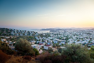
Bodrum is a municipality and district of Muğla Province, Turkey. Its area is 650 km2, and its population is 192,964 (2022). It is a port city at the entrance to the Gulf of Gökova. Known in ancient times as Halicarnassus, the city was once home to the Mausoleum at Halicarnassus, also known as the tomb of Mausolus, one of the Seven Wonders of the Ancient World.
Marmaris is a municipality and district of Muğla Province, Turkey. Its area is 906 km2, and its population is 97,818 (2022). It is a port city and tourist resort on the Mediterranean coast, along the shoreline of the Turkish Riviera.
Muğla is a city in southwestern Türkiye. The city is the center of the district of Menteşe and Muğla Province, which stretches along Türkiye's Aegean coast. Muğla's center is situated inland at an altitude of 660 m and lies at a distance of about 30 km (19 mi) from the nearest seacoast in the Gulf of Gökova to its south-west. Muğla (Menteşe) district area neighbors the district areas of Milas, Yatağan and Kavaklıdere to its north by north-west and those of Ula and Köyceğiz, all of whom are dependent districts. Muğla is the administrative capital of a province that incorporates internationally well-known and popular tourist resorts such as Bodrum, Marmaris, Datça, Dalyan, Fethiye, Ölüdeniz and also the smaller resort of Sarigerme.
Gulf of Gökova or Gulf of Kerme, is a long (100 km), narrow gulf of the Aegean Sea between Bodrum and Datça peninsulas in south-west Turkey.
The Datça Peninsula, also known as the Reşadiye Peninsula, is an 80 km-long, narrow peninsula in southwest Turkey separating the Gulf of Gökova to the north from the Hisarönü to the south. The peninsula corresponds almost exactly to the administrative district of Datça, part of Muğla Province. The town of Datça is located at its halfway point.
Çeşme is a municipality and district of İzmir Province, Turkey. Its area is 285 km2, and its population is 48,924 (2022). It sits at Turkey's westernmost end, on a promontory on the tip of the peninsula that also carries the same name and that extends inland to form a whole with the wider Urla-Karaburun-Çeşme Peninsula. It is a popular holiday resort and the district center, where two thirds of the district population is concentrated. Çeşme is located 85 km west of İzmir, the largest metropolitan center in Turkey's Aegean Region. There is a six-lane highway connecting the two cities. Çeşme district has two neighboring districts, Karaburun to the north and Urla to the east, both of which are also part of İzmir Province. The name "Çeşme" means "fountain" and possibly draws reference from the many Ottoman fountains that are scattered across the city.
Urla is a municipality and district of İzmir Province, Turkey. Its area is 727 km2, and its population is 74,736 (2022). Agricultural products, and especially the fresh produce for the vast nearby market of İzmir, occupy a prominent place in Urla's economy, with fish, poultry and flowers standing out. An annual international Artichoke Festival has been celebrated since 2015.
The Turkish Riviera, also known popularly as the Turquoise Coast, is an area of southwest Turkey encompassing the provinces of Antalya and Muğla, and to a lesser extent Aydın, southern İzmir and western Mersin. The combination of a favorable climate, warm sea, mountainous scenery, fine beaches along more than a 1,000 km (620 mi) of shoreline along the Mediterranean and Aegean waters, and abundant natural and archaeological points of interest makes this stretch of Turkey's coastline a popular national and international tourist destination.
İçmeler is a neighbourhood of the municipality and district of Marmaris, Muğla Province, Turkey. Its population is 6,735 (2022). Before the 2013 reorganisation, it was a town (belde). It is a popular holiday resort situated 8 kilometres southwest of Marmaris. İçmeler Bay is located on the Datça Peninsula. The town is surrounded on three sides by pine forests. Hiking on the mountains is very popular and provides fantastic views of the region.
Bozburun is a neighbourhood of the municipality and district of Marmaris, Muğla Province, Turkey. Its population is 2,238 (2022). Before the 2013 reorganisation, it was a town (belde). It is situated on the coast of the peninsula of the same name which extends in parallel to Datça Peninsula in the south. The town faces across the sea the town of Datça and the Greek island of Symi
Akyaka is a neighbourhood of the municipality and district of Ula, Muğla Province, Turkey. Its population is 3,147 (2022). Before the 2013 reorganisation, it was a town (belde). The town is situated at the far end of the Gulf of Gökova, at the start of the fertile Gökova plain, and is a rising center for international tourism. It is the first coastal town encountered on the busy road from the province center of Muğla to the resort center of Marmaris. Nearby Sakar Pass is a paragliding spot where the road descends from an altitude of 670m to sea-level in the space of a pine-clad section of a dozen kilometers along very sharp curves. At the base of the hill is the intersection to Akyaka.
Gümüşlük is a neighbourhood of the municipality and district of Bodrum, Muğla Province, Turkey. Its population is 4,478 (2022). Before the 2013 reorganisation, it was a town (belde). It is a seaside village and fishing port.
Koma tou Gialou is a village in the Famagusta District of Cyprus, located on the Karpas Peninsula. It is under the de facto control of Northern Cyprus, where it is part of the İskele District.
Gökova is a neighbourhood of the municipality and district of Ula, Muğla Province, Turkey. Its population is 2,098 (2022). Before the 2013 reorganisation, it was a town (belde). It lies at the head of the Gulf of Gökova in a plain also known as Gökova. The ancient Carian city of Idyma, with its acropolis and necropolis, is located above Kozlukuyu Mahallesi at the northern end of Gökova town, not at nearby Akyaka as often incorrectly stated.
The Carian Trail is an 820 km long-distance footpath exploring the South Western corner of Turkey through the modern provinces of Muğla and Aydın. The trail is officially opened in 2013 and winds through some of the lesser known regions of Turkey.
On 21 July 2017, a large earthquake measuring 6.6 on the moment magnitude scale struck right near Bodrum, a popular town of tourism in Turkey, killing 2 and injuring hundreds. Mostly referenced as the 2017 Bodrum–Kos earthquake, this earthquake generated a tsunami which was one of the largest tsunamis in the Mediterranean Sea region.
This page is based on this Wikipedia article Text is available under the CC BY-SA 4.0 license; additional terms may apply. Images, videos and audio are available under their respective licenses.