Fairmount Township, Pennsylvania

Last updated

Fairmount Township, Pennsylvania
Ricketts Glen State Park Beach 2.jpg
Beach on Lake Jean in Ricketts Glen State Park, Fairmount Township
Map of Luzerne County, Pennsylvania Highlighting Fairmount Township.PNG
Map of Luzerne County highlighting Fairmount Township
Map of Pennsylvania highlighting Luzerne County.svg
Map of Pennsylvania highlighting Luzerne County
Country United States
State Pennsylvania
County Luzerne
Area
[1]
  Total
46.21 sq mi (119.68 km2)
  Land45.71 sq mi (118.39 km2)
  Water0.50 sq mi (1.28 km2)
Population
 (2020) [2]
  Total
1,207 Decrease2.svg
  Estimate 
(2021) [2]
1,209
  Density27.43/sq mi (10.59/km2)
Time zone UTC-5 (Eastern (EST))
  Summer (DST) UTC-4 (EDT)
FIPS code 42-079-24752

Fairmount Township is a township in Luzerne County, Pennsylvania, United States. The population was 1,207 at the 2020 census. [2] Fairmount Township is home to Ricketts Glen State Park. The park receives tens of thousands of visitors each year.

Contents

History

Early history

Native American pot found along Kitchen Creek (c. 1890) G Murray Reynolds Pot 1900.PNG
Native American pot found along Kitchen Creek (c. 1890)

Fairmount Township is in Pennsylvania, where humans have lived since at least 10000 BC. The first settlers in the state were Paleo-Indian nomadic hunters known from their stone tools. [3] [4] The hunter-gatherers of the Archaic period, which lasted locally from 7000 to 1000 BC, used a greater variety of more sophisticated stone artifacts. The Woodland period marked the gradual transition to semi-permanent villages and horticulture, between 1000 BC and 1500 AD. Archeological evidence found in the state from this time includes a range of pottery types and styles, burial mounds, pipes, bows and arrows, and ornaments. [3]

Fairmount Township is in the Susquehanna River drainage basin, the earliest recorded inhabitants of which were the Iroquoian-speaking Susquehannocks. They were a matriarchal society that lived in stockaded villages of large longhouses, but their numbers were greatly reduced by disease and warfare with the Five Nations of the Iroquois, and by 1675 they had died out, moved away, or been assimilated into other tribes. [4] [5]

After the demise of the Susquehannocks, the lands of the Susquehanna River valley were under the nominal control of the Iroquois, who also lived in longhouses, primarily in what is now the state of New York. The Iroquois had a strong confederacy which gave them power beyond their numbers. [4] [6] To fill the void left by the demise of the Susquehannocks, the Iroquois encouraged displaced tribes from the east to settle in the Susquehanna watershed, including the Shawnee and Lenape (or Delaware). [4] [5]

The French and Indian War (1754–1763) and subsequent colonial expansion encouraged the migration of many Native Americans westward to the Ohio River basin. [4] On November 5, 1768, the British acquired land, known in Pennsylvania as the New Purchase, from the Iroquois in the Treaty of Fort Stanwix; this included what is now Fairmount Township. [7] After the American Revolutionary War, Native Americans almost entirely left Pennsylvania. [8] In 1890, a Native American pot, decorated in the style of "the peoples of the Susquehanna region," was found under a rock ledge on Kitchen Creek by Murray Reynolds. [9]

Township

The first Europeans came to the region in the 18th century. The first settler in the township was John Franklin of Connecticut. Additional settlers followed in Franklin's footsteps (e.g., Levi Seward and Nathaniel Goss). Under the Connecticut title—previous to 1776—it was originally known as Bloomingdale Township. The name was changed to Huntington Township in 1799 in honor of Samuel Huntington, a native of Connecticut and one of the signers of the Declaration of Independence. Fairmount Township broke away from Huntington Township in the 1830s; it was officially incorporated as a township in 1834. [10]

Geography

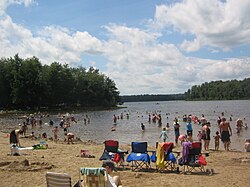
According to the United States Census Bureau, the township has a total area of 46.2 square miles (119.7 km2), of which 45.7 square miles (118.4 km2) is land and 0.50 square miles (1.3 km2), or 1.07%, is water. [11] It is located in the northwestern corner of Luzerne County. The northern portion of Fairmount Township is mostly made up of mountains, lakes, streams, and thick forests. Ricketts Glen State Park is located in this half of the township. The southern half of Fairmount Township consists mostly of farmland and forests; the villages of Mossville and Rittenhouse are located in this part of the township. PA 118 and PA 487 intersect in the western part of the township in the village of Red Rock.

Ricketts Glen State Park

Much of Ricketts Glen State Park is in Fairmount Township. The park offers hiking, camping, horseback riding, and hunting. Lake Jean is used for swimming, fishing, canoeing, and kayaking. In winter there is cross-country skiing, ice fishing on the lake, and ice climbing on the frozen falls. Almost all of Kitchen Creek and the 24 named waterfalls are in the township.

Map of Ricketts Glen State Park (in northern Fairmount Township) Ricketts Glen State Park Map.pngRicketts GlenRicketts Glen State ParkKitchen CreekAdams FallsKitchen Creek FallsShingle Cabin FallsMurray Reynolds FallsSheldon Reynolds FallsHarrison Wright FallsWaters MeetGlen LeighWyandot FallsB. Reynolds FallsR. B. Ricketts FallsOzone FallsHuron FallsShawnee FallsF.L. Ricketts FallsOnondaga FallsGanoga GlenErie FallsTuscarora FallsConestoga FallsMohican FallsDelaware FallsSeneca FallsGanoga FallsCayuga FallsOneida FallsMohawk FallsLake JeanLake RoseLake LeighBig Run (Fishing Creek tributary)
Map of Ricketts Glen State Park (in northern Fairmount Township)
Ricketts Glen State Park 24 named waterfalls.jpg
There are 24 named waterfalls in Fairmount Township.

Demographics

Historical population
CensusPop.Note
2000 1,226
2010 1,2764.1%
2020 1,207−5.4%
2021 (est.)1,209 [2] 0.2%

As of the census [12] of 2000, there were 1,226 people, 490 households, and 347 families residing in the township. The population density was 26.9 inhabitants per square mile (10.4/km2). There were 598 housing units at an average density of 13.1/sq mi (5.1/km2). The racial makeup of the township was 97.72% White, 0.57% African American, 0.98% Native American, 0.16% Asian, 0.08% Pacific Islander, and 0.49% from two or more races. Hispanic or Latino of any race were 0.33% of the population.

There were 490 households, out of which 28.6% had children under the age of 18 living with them, 61.6% were married couples living together, 5.1% had a female householder with no husband present, and 29.0% were non-families. 25.9% of all households were made up of individuals, and 10.8% had someone living alone who was 65 years of age or older. The average household size was 2.50 and the average family size was 2.99.

In the township the population was spread out, with 24.1% under the age of 18, 7.5% from 18 to 24, 28.6% from 25 to 44, 25.4% from 45 to 64, and 14.4% who were 65 years of age or older. The median age was 40 years. For every 100 females, there were 106.7 males. For every 100 females age 18 and over, there were 106.4 males.

The median income for a household in the township was $37,656, and the median income for a family was $45,208. Males had a median income of $31,979 versus $21,103 for females. The per capita income for the township was $16,334. About 7.4% of families and 10.1% of the population were below the poverty line, including 18.3% of those under age 18 and 9.4% of those age 65 or over.

Related Research Articles

<span class="mw-page-title-main">Fishing Creek Township, Columbia County, Pennsylvania</span> Township in Pennsylvania, United States

Fishing Creek Township is a township in Columbia County, Pennsylvania. It is part of Northeastern Pennsylvania. The population was 1,416 at the 2010 census.

<span class="mw-page-title-main">Manor Township, Lancaster County, Pennsylvania</span> Township in Pennsylvania, United States

Manor Township is a second-class township in west-central Lancaster County, Pennsylvania, United States. As of the 2020 census, it had a population of 21,920.

<span class="mw-page-title-main">Duryea, Pennsylvania</span> Borough in Pennsylvania, United States

Duryea is a borough in the Greater Pittston area of Luzerne County, Pennsylvania, United States, 9 miles (14 km) south of Scranton. The Susquehanna River marks Duryea's western boundary and the Lackawanna River flows through Duryea. It was incorporated as a borough in 1901, and had a notable switching rail yard, the Duryea yard, connecting the central Wyoming Valley to destinations in lower New York and down-state Pennsylvania. Coal mining and silk manufacturing were the chief industries in Duryea's early years. The population was 5,032 at the 2020 census.

<span class="mw-page-title-main">Exeter, Pennsylvania</span> Borough in Pennsylvania, United States

Exeter is a borough in the Greater Pittston-Wilkes-Barre area of Luzerne County, Pennsylvania, United States, about 10 miles (16 km) west of Scranton and a few miles north of Wilkes-Barre. It is located on the western bank of the Susquehanna River and has a total area of 5.0 square miles (12.9 km2). As of 2020, Exeter had a population of 5,513.

<span class="mw-page-title-main">Exeter Township, Luzerne County, Pennsylvania</span> Township in Pennsylvania, United States

Exeter Township is a township within the Greater Pittston area of Luzerne County, Pennsylvania, United States. The population was 2,047 at the 2020 census. Upper Exeter and Harding are two villages in the township.

<span class="mw-page-title-main">Hanover Township, Luzerne County, Pennsylvania</span> Township in Pennsylvania, United States

Hanover Township is a township in Luzerne County, Pennsylvania. As of the 2020 census, the population was 11,424, making it the most populous township in the county.

<span class="mw-page-title-main">Huntington Township, Luzerne County, Pennsylvania</span> Township in Pennsylvania, United States

Huntington Township is an American township which is in Luzerne County, Pennsylvania. The population was 2,052 at the time of the 2020 census.

<span class="mw-page-title-main">Lehman Township, Luzerne County, Pennsylvania</span> Township in Pennsylvania, United States

Lehman Township is a township in Luzerne County, Pennsylvania, United States. The township is part of the Back Mountain. The campus of Penn State Wilkes-Barre is located at the Hayfield Farms on Old Route 115 in Lehman Township. The township population was 3,342 at the 2020 census.

<span class="mw-page-title-main">Plains Township, Pennsylvania</span> Township in Pennsylvania, United States

Plains Township is a township in Luzerne County, Pennsylvania, United States. The population was 9,816 at the 2020 census. The municipality is the birthplace of Chicago White Sox hall of famer Ed Walsh and John J. Yeosock, a United States Army general who commanded the 3rd U.S. Army during Operation Desert Shield and Operation Desert Storm. Mohegan Pennsylvania is a casino in Plains Township.

<span class="mw-page-title-main">Ross Township, Luzerne County, Pennsylvania</span> Township in Pennsylvania, United States

Ross Township is a township in Luzerne County, Pennsylvania, United States. The population was 2,719 at the 2020 census.

<span class="mw-page-title-main">Salem Township, Luzerne County, Pennsylvania</span> Township in Pennsylvania, United States

Salem Township is a township in Luzerne County, Pennsylvania, United States. The population was 4,019 at the 2020 census. The Susquehanna Steam Electric Station, a nuclear power plant, is located in Salem.

<span class="mw-page-title-main">Sugarloaf Township, Luzerne County, Pennsylvania</span> Township in Pennsylvania, United States

Sugarloaf Township, or Sugarloaf for short, is a township that is located in Luzerne County, Pennsylvania, United States. The population was 3,879 at the time of the 2020 census.

<span class="mw-page-title-main">Union Township, Luzerne County, Pennsylvania</span> Township in Pennsylvania, United States

Union Township is a township in Luzerne County, Pennsylvania, United States. The population was 2,033 at the 2020 census.

<span class="mw-page-title-main">Wyoming, Pennsylvania</span> Borough in Luzerne County, Pennsylvania, US

Wyoming is a borough in the Greater Pittston area of Luzerne County, Pennsylvania, United States. It is located 5 miles (8 km) north of Wilkes-Barre, along the Susquehanna River. The population was 3,097 as of the 2020 census.

<span class="mw-page-title-main">Danville, Pennsylvania</span> Borough in Pennsylvania, United States

Danville is a borough in and the county seat of Montour County, Pennsylvania, United States, along the North Branch of the Susquehanna River. The population was 4,221 at the 2020 census. Danville is part of the Bloomsburg-Berwick micropolitan area.

<span class="mw-page-title-main">Colley Township, Sullivan County, Pennsylvania</span> Township in Pennsylvania, United States

Colley Township is a township in Sullivan County, Pennsylvania, United States. The population was 626 at the 2020 census. The village of Lopez is located in the township.

<span class="mw-page-title-main">Bridgewater Township, Pennsylvania</span> Township in Pennsylvania, United States

Bridgewater Township is a township in Susquehanna County, Pennsylvania, United States. The population was 2,582 at the 2020 census, but is now estimated to be 2,754.

<span class="mw-page-title-main">Harford Township, Susquehanna County, Pennsylvania</span> Township in Pennsylvania, United States

Harford Township is a township in Susquehanna County, Pennsylvania, United States. The population was 1,255 at the 2020 census.

<span class="mw-page-title-main">New Milford Township, Pennsylvania</span> Township in Pennsylvania, United States

New Milford Township is a township in Susquehanna County, Pennsylvania, United States. The population was 1,797 at the 2020 census. Children living in New Milford Township are served by the schools in the Blue Ridge School District, including Blue Ridge High School.

<span class="mw-page-title-main">Silver Lake Township, Pennsylvania</span> Township in Pennsylvania, United States

Silver Lake Township is a township in Susquehanna County, Pennsylvania, United States. The population was 1,525 at the 2020 census. The village of Brackney is in the township.

References

  1. "2016 U.S. Gazetteer Files". United States Census Bureau. Retrieved August 14, 2017.
  2. 1 2 3 4 "City and Town Population Totals: 2020—2021". Census.gov. US Census Bureau. Retrieved August 3, 2022.
  3. 1 2 Kent, Smith, McCann, pp. 4, 7–11, 85–96, 195–201.
  4. 1 2 3 4 5 Wallace (2005), pp. 4–12, 84–89, 99–105, 145–148, 157–164.
  5. 1 2 Donehoo, pp. 154–155, 215–219.
  6. Wallace (1987), pp. 66–72, 130–132.
  7. Wallace (2005), p. 159.
  8. Wallace (2005), pp. 136–141.
  9. Wren, p. 56, Plate No. 7.
  10. "HISTORY OF LUZERNE LACKAWANNA and WYOMING COUNTIES".
  11. "Profile of General Population and Housing Characteristics: 2010 Demographic Profile Data (DP-1): Fairmount township, Luzerne County, Pennsylvania". United States Census Bureau . Retrieved April 16, 2012.
  12. "U.S. Census website". United States Census Bureau . Retrieved January 31, 2008.

41°19′00″N76°16′59″W / 41.31667°N 76.28306°W / 41.31667; -76.28306