For the 118th and successive Congresses (based on redistricting following the 2020 census), the district contains all or portions of the following counties and communities:[8]
2003–2013 The district covered areas further east and encompassed much of Polk County as well as parts of rural and suburban east Hillsborough County and a small piece of western Osceola County, which later became the center of the 9th district.
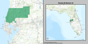
↑ See whole Florida state map for 2013, with the 12th district covering Pasco County and counties below: h9047_35x42L.pdfCongressional Plan: H000C9047. Chapter No. 2012-2, Laws of Florida. www.flsenate.gov. February 16, 2012.
↑ See the 2013 boundaries of the 12th district, covering Pasco County and northern Pinellas County and northwest Hillsborough in the 2013 districts map: H000C9047_map_sw.pdf, for the southwest region of Florida. Congressional Plan: H000C9047. Chapter No. 2012-2, Laws of Florida. www.flsenate.gov. February 2012.
This page is based on this Wikipedia article Text is available under the CC BY-SA 4.0 license; additional terms may apply. Images, videos and audio are available under their respective licenses.