Forncett railway station

Last updated

Forncett
Forncett station (remains) geograph-3524685-by-Ben-Brooksbank.jpg
Remains of the station in 1993
General information
Location Forncett, District of South Norfolk
England
Grid reference TM17259350
Platforms2
Other information
StatusDisused
History
Pre-grouping Eastern Union Railway
Great Eastern Railway
Post-grouping London and North Eastern Railway
Eastern Region of British Railways
Key dates
12 December 1849Opened [1]
28 December 1964Closed to freight
7 November 1966Closed to passengers [1]

Forncett railway station was a railway station in Forncett, South Norfolk located 104 miles from London Liverpool Street. It was opened in 1849 when Norwich and Ipswich were connected by the Eastern Union Railway in 1849. Between 1881 and 1951 it was a junction for a short route to Wymondham and was closed as a result of the Beeching Axe with other smaller stations between Norwich and Ipswich.

Contents

Description (post 1881)

The station consisted of two platforms with the up (to London) platform being 363 feet and the down (from London) platform 452 feet. The station building was situated on the up side with a wooden waiting shelter located on the down. The two platforms were linked by a footbridge provided in 1882. A goods yard consisting of three sidings and a brick goods shed was located south of the station on the up side.

Long refuge sidings were provided north of the station with a 44 foot turntable being provided on the up side in 1881 in connection with the line to Wymondham.

The station signal box was located at the north end of the down platform. A short distance to the north a second signal box called Forncett Junction was located controlling access to and from the Wymondham line some 30 chains to the north. [2]

History

Opening and early years (1849-1862)

Forncett station was opened on 7 November 1849 by the Eastern Union Railway although regular services did not commence until 12 December that year. The opening of the line meant that London Liverpool Street and Norwich (Victoria) were linked although the Eastern Counties Railway (ECR) operated the line as far as Colchester and the EUR between Colchester and Norwich. The ECR already operated the Norwich to London via Thetford and Cambridge route at this date.

The EUR was taken over by the Eastern Counties Railway in 1854. However, by the 1860s the railways in East Anglia were in financial trouble, and most were leased to the ECR. It wished to amalgamate formally but could not obtain government agreement for this until 1862, when the Great Eastern Railway (GER) was formed by the amalgamation. [3]

Great Eastern Railway (1862-1922)

The Great Eastern Railway opened the Wymondham – Forncett line on 7 May 1881 and facilities such as the turntable (diameter 44 feet 9 inches) and footbridge were added at this time. The intention was to give the line from Wells-next-the-Sea a connection into Norwich to Liverpool Street trains at Forncett and vice versa. For example in 1882 the 1.50 pm departure from Wells arrived at Forncett at 3.08 pm in time to connect to the up express and arrive in Liverpool Street at 6.00 pm.

In 1892 a locomotive inspection pit was added.

On 22 February 1908 a violent storm partially wrecked the down timber built platform.

Heavy flooding on 26 August 1912 saw the main line north of Forncett Junction closed with trains diverted via Wymondham. Damage to several bridges saw the diversions continue until 2 October.

Although there was no engine shed as such Forncett had, in 1917 two drivers and a fireman for local workings. No locomotive was allocated and it is likely these would have come from Norwich engine shed. [4]

In the final year of GER operation, there were no through trains from Wells to Forncett although a branch service of six trains per day operated to Wymondham. [5]

London & North Eastern Railway (1923-1948)

Following the passing of the Railways Act 1921o 1 January 1923 the operation of Forncett station was taken over by the London and North Eastern Railway (LNER).

In 1925 the LNER closed Forncett Junction signal box transferring its signalling responsibilities to the station signal box.

Passenger services were withdrawn from the Forncett - Wymondham line on 11 September 1939 as a wartime economy measure. This line saw some additional traffic during the World War II but at one stage one of the running lines was being used as a siding for damaged rolling stock. [5]

British Railways (1948-1966)

Following nationalisation in 1948 the station became part of the Eastern Region of British Railways. The passenger service had not been restored after the war and by the July 1950 timetable change there was no traffic at all from Forncett towards Wymondham. The line was closed in August 1951. [6]

Freight, which for many years during the 1950s consisted of a daily pick-up freight train between Norwich and Stowmarket, was finally withdrawn on 28 December 1964. [7]

The last passenger trains called on 5 November 1966 when the Ipswich to Norwich stopping service was withdrawn.

Since closure

The line to Norwich remains in operational use and was electrified in May 1987. [8]

The station was in the news in July 2012 when the body of a woman who had died after being hit by a train was found at the site. [9]

Preceding station Disused railways Following station
Flordon
Line open, station closed
  Great Eastern Railway
Great Eastern Main Line
  Tivetshall
Line open, station closed
Ashwellthorpe
Line and station closed
  

Related Research Articles

Great Eastern Main Line 133 mile major railway line of the British railway system

The Great Eastern Main Line is a 114.5-mile (184.3 km) major railway line on the British railway system which connects Liverpool Street station in central London with destinations in east London and the East of England, including Shenfield, Chelmsford, Colchester, Ipswich and Norwich. Its numerous branches also connect the main line to Southminster, Braintree, Sudbury, Harwich and a number of coastal towns including Southend-on-Sea, Clacton-on-Sea, Walton-on-the-Naze and Lowestoft.

Great Eastern Railway Pre-grouping British railway company

The Great Eastern Railway (GER) was a pre-grouping British railway company, whose main line linked London Liverpool Street to Norwich and which had other lines through East Anglia. The company was grouped into the London and North Eastern Railway in 1923.

Norwich railway station Railway station in Norwich, England

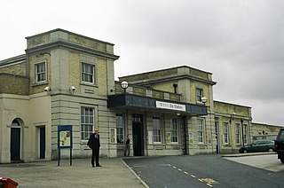
Norwich railway station is the northern terminus of the Great Eastern Main Line in the East of England, serving the city of Norwich, Norfolk. It is 114 miles 77 chains (185.0 km) down the main line from London Liverpool Street, the western terminus.

Ipswich railway station Railway station in Suffolk, England

Ipswich railway station is on the Great Eastern Main Line in the East of England, serving the town of Ipswich, Suffolk. It is 68 miles 59 chains (110.6 km) down the line from London Liverpool Street and, on the main line, it is situated between Manningtree to the south and Needham Market to the north.

Ely railway station Railway station in Cambridgeshire, England

Ely railway station is on the Fen line in the east of England, serving the city of Ely, Cambridgeshire. It is 70 miles 30 chains (113.3 km) from London Liverpool Street and is situated between Waterbeach and Littleport stations on the Fen line to King's Lynn. It is an important junction for three other lines; the Ely to Peterborough Line, the Ipswich to Ely Line and the Norwich to Ely line.

Breckland line

The Breckland line is a secondary railway line in the east of England that links Cambridge in the west to Norwich in the east. The line runs through three counties: Cambridgeshire, Suffolk and Norfolk. It takes its name from the Breckland region of Norfolk, and passes through Thetford Forest.

Cambridge railway station Railway station in Cambridge, England

Cambridge railway station is the principal station serving the city of Cambridge in the east of England. It stands at the end of Station Road, 1 mile (1.6 km) south-east of the city centre. It is the northern terminus of the West Anglia Main Line, 55 miles 52 chains (89.6 km) down the line from London Liverpool Street, the southern terminus.

Brentwood railway station Railway station in Essex, England

Brentwood railway station is on the Great Eastern Main Line in the East of England, serving the town of Brentwood, Essex. It is 18 miles 16 chains (29.3 km) down the line from London Liverpool Street and is situated between Harold Wood and Shenfield. Its three-letter station code is BRE.

Stowmarket railway station Grade II listed railway station in Suffolk, England

Stowmarket railway station is on the Great Eastern Main Line (GEML) in the East of England, serving the town of Stowmarket, Suffolk. It is 80 miles 9 chains (128.9 km) down the line from London Liverpool Street and is situated between Needham Market to the south and Diss to the north. It is also the junction where the Ipswich to Ely Line joins the GEML. Its three-letter station code is SMK.

Witham railway station Railway station in Essex, England

Witham railway station is on the Great Eastern Main Line (GEML) in the East of England, serving the town of Witham, Essex. It is about half a mile (1 km) to the north of the town centre and is 38 miles 48 chains (62.1 km) down the line from London Liverpool Street. On the GEML Witham is situated between Hatfield Peverel to the west and Kelvedon to the east. It is the junction for the Braintree Branch Line to the east which opened in 1848, and between 1848 and 1964 it was also the junction for a west-facing branch line to Maldon. Its three-letter station code is WTM.

Wymondham railway station Railway station in Norfolk, England, United Kingdom

Wymondham railway station is on the Breckland Line in the East of England, serving the town of Wymondham, Norfolk. The line runs between Cambridge in the west and Norwich in the east. It is situated between Spooner Row and Norwich, 113 miles 72 chains (183.3 km) from London Liverpool Street via Ely.

Spooner Row railway station Railway Station in Norfolk, England

Spooner Row railway station is on the Breckland line in the East of England, serving the village of Spooner Row, Norfolk. The line runs between Cambridge in the west and Norwich in the east.

Diss railway station Railway station in Norfolk, England

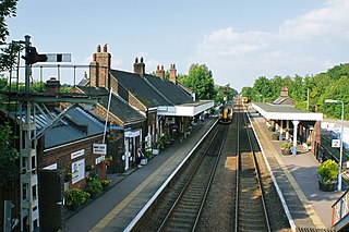
Diss railway station is on the Great Eastern Main Line in the East of England, serving the town of Diss, Norfolk. It is 94 miles 43 chains (152.1 km) down the line from London Liverpool Street and is situated between Stowmarket to the south and Norwich to the north. It is approximately 20 miles (32 km) south of Norwich. Its three-letter station code is DIS.

Ashwellthorpe railway station Former railway station in Norfolk, England

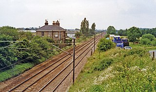
Ashwellthorpe was a railway station that existed in the village of Ashwellthorpe, Norfolk, on a cutoff line between Forncett and Wymondham. This entry covers the history of the line and the station.

Wells-next-the-Sea railway station Former railway station in North Norfolk, England

Wells-next-the-Sea railway station served the port town of Wells-next-the-Sea in North Norfolk, England. It was opened in 1857 by the Wells & Fakenham Railway, later part of the Great Eastern Railway's Wymondham to Wells branch, and became a junction in 1866 with the arrival of the West Norfolk Junction Railway. It closed in 1964.

Mellis railway station

Mellis railway station was a station in Mellis, Suffolk, England. It was opened in 1849 by the Eastern Union Railway on the Great Eastern Main Line from London to Norwich. In 1867 the Eye Branch was opened and Mellis became a railway junction.

Finningham railway station was a station physically located in the neighbouring parish of Bacton, Suffolk on the Great Eastern Main Line between London and Norwich. It was located 86 miles and 54 chains from Liverpool Street and was opened to passenger in 1849. It was closed in 1966 as part of the Beeching Axe with other smaller stations on the line although the line remains open.

Haughley railway station was located in Haughley, Suffolk on the Great Eastern Main Line between Liverpool Street Station and Norwich. It opened on 7 July 1849 named Haughley Junction and was a replacement for a station named Haughley Road which had been in service from 1846 to 1849 at location TM 02981 63319 on the line to Elmswell.

Bentley railway station (Suffolk)

Bentley railway station, also known as Bentley Junction between 1849 and 1878, was located in Bentley, Suffolk on the Great Eastern Main Line. It opened in 1846 and became a junction in 1847 when the Hadleigh Railway opened. The station was closed in 1966.

The Wymondham to Wells Branch was a railway built in stages by the Norfolk Railway, Eastern Counties Railway and Wells and Fakenham Company between 1847 and 1857. The railway ran from Wymondham in the south, through Dereham and Fakenham to the coastal town of Wells-next-the-Sea; more specifically, the line ran from Wymondham South Junction, where it met the present-day Breckland Line. Passenger services along the line lasted until 1969; the railway continued to be used for freight until 1989. The southern section of the railway now forms the Mid-Norfolk Railway, with part of the northern section serving as the narrow gauge Wells and Walsingham Light Railway.

References

  1. 1 2 Butt, R. V. J. (1995). The Directory of Railway Stations: details every public and private passenger station, halt, platform and stopping place, past and present (1st ed.). Sparkford: Patrick Stephens Ltd. p. 98. ISBN   978-1-85260-508-7. OCLC   60251199.
  2. Jenkins, Stanley (April 2004). "The Wymondham - Forncett line". Great Eastern Journal. 118: 5, 6.
  3. Vaughan, Adrian (1997). Railwaymen, Politics and Money. London: John Murray. pp.  134, 135. ISBN   0 7195 5150 1.
  4. Hawkins, Chris; Reeve, George (1986). Great Eastern Railway Engine Sheds Part 1. Didcot: Wild Swan. p. 217. ISBN   0 906867 40 1.
  5. 1 2 Jenkins, Stanley (April 2004). "The Wymondham - Forncett line". Great Eastern Journal. 118: 4.
  6. Jenkins, Stanley (April 2004). "The Wymondham - Forncett line". Great Eastern Journal. 118: 9.
  7. Robertson, Alic; Walsh, Bernard (July 1997). "GE station survey -Finningham (Suffolk)". Great Eastern Journal. 91: 33.
  8. Adderson, Richard; Kenworthy, Graham (2015). Ipswich - Diss. Midhurst UK: Middleton Press. p. 97. ISBN   978 1 908174 81 9.
  9. Woman dies after being hit by a train near disused Norfolk station

Coordinates: 52°29′47″N1°11′56″E / 52.4963°N 1.1990°E / 52.4963; 1.1990