German Reformed Sanctity Church Parsonage

Last updated
German Reformed Sanctity Church Parsonage
German Reformed Sanctity Church and Parsonage, Germantown, NY.jpg
South (front) facade, 2013
USA New York location map.svg
Red pog.svg
Usa edcp location map.svg
Red pog.svg
Location Germantown, New York
Coordinates 42°8′30″N73°52′57″W / 42.14167°N 73.88250°W / 42.14167; -73.88250 Coordinates: 42°8′30″N73°52′57″W / 42.14167°N 73.88250°W / 42.14167; -73.88250
Area1.3 acres (5,300 m2)
Builtc. 1746
NRHP reference No. 76001209 [1]
Added to NRHPJanuary 30, 1976

The German Reformed Sanctity Church Parsonage, also known as the First Reformed Church Parsonage, [2] is located on Maple Avenue in Germantown, New York, United States. It is a wood, brick and stone building dating to the mid-18th century, [3] the oldest building in the town of Germantown. [2] In 1976 it was listed on the National Register of Historic Places. [1]

Contents

At the time of its construction the area, known as East Camp, supported a thriving Palatine German population. The residents were either refugees who had fled to England during the War of the Spanish Succession and been resettled in the Hudson Valley as part of a failed scheme to produce naval stores in the Hudson Valley, or their descendants; many later generations in turn moved on to other areas. The church had been established shortly after the first Palatines arrived; the parsonage was built in the 1740s. Two decades later it was expanded to its current size.

The church sold the house in the early 19th century; its pastors continued to live there for another quarter-century. Throughout most of the later 19th and 20th centuries it housed different local families, primarily African American. By the 1940s it required extensive renovations that added modern amenities.

Today it is the property of the town of Germantown. [3] It houses the town's history department. An archaeological dig in the vicinity by a professor at nearby Bard College has yielded many artifacts, some of which are on display inside. [2] Information about Bard's dig can be found online in a Germantown Exhibits portal.

Building

The parsonage sits on a 1.3-acre (5,300 m2) lot on the north side of Maple Avenue, roughly a thousand feet (300 m) east of New York State Route 9G, on the northern edge of the developed areas of central Germantown. Its neighborhood is rural in character, with two farms to the west on either side of Maple and houses on similarly sized lots to the east. On the north is a large woodlot; a smaller one to the south buffers the baseball diamonds and fields of nearby Palatine Park. [4] The terrain slopes gently westward to the Hudson River, a half-mile (800 m) in that direction. [5]

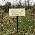
In front of the building is a low stone wall, a memorial to the early settlers and a modern interpretive plaque. The parsonage itself is a one-and-a-half-story five-by-three-bay structure in two sections, one fieldstone, the other wooden with a side-gabled roof. Brick chimneys pierce the roof at either end. It is built into a slope that exposes the basement on the east side. [3]

The walls of the eastern section are three feet (1 m) thick; consisting of stone blocks faced with stucco and bound by hair and lime mortar in an interior and exterior section with dead air space in between and painted on the outside. On the west the structural system consists of wood frame filled with bricks and faced in asbestos shingles. [3] All windows are recessed and set with double-hung sash. [6]

Window treatments depend on the location. On the exposed portion of the basement, the two windows are eight-over-eight in plain surrounds. Above, on the first story, they are 12-over-12 in recessed surrounds topped by a slight decorative recessed arch over the lintel. The east section is set with two six-over-six modern storm windows in plain surrounds. A small single-pane casement window is located just below the roofline between the center bay and the first one to its west. [6]

On the sides, the building is blind on its basement and first story. The rear has one door leading to the kitchen and another to the cellar. Above a cornice at the south elevation's roofline, the east gable field is faced in wood, with two one-over-one double-hung sash. The steeply pitched roof has slight overhanging eaves and is covered in slate shingles. [3]

The main entrance consists of a modern two-paned glass door in front of an older wooden door with recessed panels on its bottom portion below a 12-light top section. It opens into the central hallway, with two rooms to the east and one to the west. Flooring throughout the house is original wide planks of pine; original pine woodwork remains in many rooms as well. The only exception is the cellar, with its original pressed clay floor. It also has a large fireplace with an oven. Upstairs, the garret is divided into three small rooms separated by a central hall. [3]

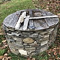
Between 2010 and 2014, students at Bard Archaeology's Field School, under the direction of Christopher Lindner, PhD, excavated the buried 18th century well and reconstructed the outer wall with the rocks that had filled the shaft's 10-foot depth. The lawn hid the slabs that rested under a thick layer of earth. A slide show of the process can be viewed online at Bard College's Archeology site. [7]

History

Displaced by the War of the Spanish Succession, refugees from Germany made their way to England in great numbers during 1709. They came to be known as Palatines even though not all of them were from the Palatinate region in the middle Rhine Valley. At a loss for how to handle them, the British government embraced a plan to resettle them in the upper Hudson Valley, where in return for their passage across the Atlantic they would collect pitch pine tar for the Royal Navy, [2] replacing naval stores previously sourced from the Baltic areas. Their presence on land colonial governor Robert Hunter had purchased for the crown from landowner Robert Livingston the Elder, one tract on the present site of Germantown, would also shore up the northern frontier of the Province of New York from the threat posed by the French to the north. [3]

Within two years of the Palatines' 1710 arrival, the naval stores venture had failed due to lack of support in Parliament and the settlers' unwillingness to see themselves as government employees. Afterwards, some left for other areas of New York, going either south to today's Rhinebeck or northwest to the Mohawk Valley. Finding the terrain similar to that they had left behind in Germany, [8] the 63 Palatine families in the "East Camp" area established farms, and by 1726 those lands were officially transferred to them by letters patent. [3]

The German Reformed Sanctity Church was established by the Palatines soon after they settled in East Camp. By the 1720s a church (no longer extant) had been built roughly two blocks west of the parsonage site. [8] Land records show the church owned the parsonage land as early as 1741. While some sources suggest the parsonage had been built by 1743, [2] it had likely been built by 1746, when Casper Ludwig Schnoor was hired as the church's first resident pastor. [3]

At that time the building consisted solely of its current western section. The entrance was originally what is now the west window of the cellar on the south elevation. [3] It is possible also that the second story and attic were added later. [9] As a whole the structure is architecturally similar to other edifices built by the Palatines in the Germantown area as well as in other areas settled by Germans around the same time, such as the Rondout Creek valley near New Paltz and, outside of New York, some areas of Pennsylvania. [3]

1798 map of Germantown showing church and parsonage 1798 Germantown map.png
1798 map of Germantown showing church and parsonage

Schnoor was replaced by Johannes Casparus Rubel in 1751. He remained there longer than his predecessor, at least through 1767 when the parsonage was expanded with the construction of the eastern wing. In 1805 the church sold the building to a woman named Maria Delamater. [3] Its pastors continued to live there until 1829, when it was sold to a local doctor of Dutch descent named Wessel Ten Broeck Van Orden. [3] [10]

Van Orden lived in the house for another two decades. After him it passed through a number of local families, primarily African Americans whom local lore has it were once slaves in the area, [11] bought it. By that time, 200 years after its construction, the house had severely deteriorated. [3] lived there for several generations. [9] In 1944 the Ekert family, then of Long Island, [11] bought it. By that time, 200 years after its construction, the house had severely deteriorated. [3]

The ensuing restoration efforts were extensive, aimed primarily at repairing the building's structural system. New framing members were cut from local oak to replace the existing ones in the west section, reinforced by concealed steel girders above the windows. Rotten floor joists were likewise capped with steel. The chimneys were repaired and the cellar door on the south facade converted into a window (supposedly for security reasons [10] ). On the inside, the kitchen was modernized and the house wired for electricity. Modern plumbing and heating systems were also added, in a way that detracted from the house's historic appearance as little as possible. [3]

In 1990 the Ekerts left the house to the town. [9] It has used it as headquarters for its historian. In the late 2000s Christopher Lindner, an archaeologist at Bard College in nearby Annandale, concentrating on Hudson Valley sites, began leading digs in the vicinity of the parsonage. These have yielded pottery fragments such as china dating to the early years of the parsonage, suggesting that the pastors of that era lived like wealthy members of society. [11] Some of them have been placed on exhibit in the house, which is open to visitors on Saturdays. [2] There is also evidence suggesting a former second structure in the yard to the west. [10]

See also

Related Research Articles

<span class="mw-page-title-main">Columbia County, New York</span> County in New York, United States

Columbia County is a county located in the U.S. state of New York. As of the 2020 census, the population was 61,570. The county seat is Hudson. The name comes from the Latin feminine form of the name of Christopher Columbus, which was at the time of the formation of the county a popular proposal for the name of the United States.

<span class="mw-page-title-main">Germantown (town), New York</span> Town in New York, United States

Germantown is a town in Columbia County, New York, United States. The population was 1,936 at the 2020 census, down slightly from 1,954 in 2010. Germantown is located in the South West part of the county along the East side of the Hudson River.

<span class="mw-page-title-main">Mount Airy, Philadelphia</span> Neighborhood of Philadelphia in Philadelphia County, Pennsylvania, United States

Mount Airy is a neighborhood of Northwest Philadelphia in the U.S. state of Pennsylvania.

<span class="mw-page-title-main">New Hurley Reformed Church</span> Historic church in New York, United States

The New Hurley Reformed Church, listed on the National Register of Historic Places (NRHP) as the Reformed Dutch Church of New Hurley, is located on New York State Route 208 roughly 3 miles (4.8 km) north of the hamlet of Wallkill, New York, United States, midway between it and Gardiner to the north, in the town of Plattekill. It is a wooden structure built in the Greek Revival style during the 1830s. In 1982 it was listed on the NRHP.

<span class="mw-page-title-main">Reformed Church of Shawangunk</span> Historic church in New York, United States

The Reformed Church of Shawangunk is located along Hoagerburgh Road in the Bruynswick section of the Town of Shawangunk, Ulster County, New York, United States. Perched above the Shawangunk Kill, it enjoys a splendid view of the nearby Shawangunk Ridge. Built between 1752–55, it is the oldest building in continuous use among American congregations of the Dutch Reformed Church.

<span class="mw-page-title-main">Montgomery Place</span> Historic house in New York, United States

Montgomery Place, now Bard College: The Montgomery Place Campus, near Barrytown, New York, United States, is an early 19th-century estate that has been designated a National Historic Landmark. It is also a contributing property to the Hudson River Historic District, itself a National Historic Landmark. It is a Federal-style house, with expansion designed by architect Alexander Jackson Davis. It reflects the tastes of a younger, post-Revolutionary generation of wealthy landowners in the Livingston family who were beginning to be influenced by French trends in home design, moving beyond the strictly English models exemplified by Clermont Manor a short distance up the Hudson River. It is the only Hudson Valley estate house from this era that survives intact, and Davis's only surviving neoclassical country house.

<span class="mw-page-title-main">Hudson River Historic District</span> Historic district in New York, United States

The Hudson River Historic District, also known as Hudson River Heritage Historic District, is the largest Federally designated district on the mainland of the contiguous United States. It covers an area of 22,205 acres extending inland roughly a mile (1.6 km) from the east bank of the Hudson River between Staatsburg and Germantown in Dutchess and Columbia counties in the U.S. state of New York. This area includes the riverfront sections of the towns of Clermont, Red Hook, Rhinebeck and part of Hyde Park. This strip includes in their entirety the hamlets of Annandale, Barrytown, Rhinecliff and the village of Tivoli. Bard College and two protected areas, Margaret Lewis Norrie State Park and Tivoli Bays Unique Area, are also within the district.

Fort Hunter is a hamlet in the Town of Florida in Montgomery County, New York, United States, west of the capital at Albany, on the south bank of the Mohawk River and on the northeast bank of Schoharie Creek.

<span class="mw-page-title-main">Winterbourne Stoke</span> Human settlement in England

Winterbourne Stoke is a village and civil parish in Wiltshire, England, about 5 miles (8 km) west of Amesbury and 3 miles (4.8 km) west of the prehistoric monument of Stonehenge.

<span class="mw-page-title-main">Hyde Park Reformed Dutch Church</span> Historic church in New York, United States

Hyde Park Dutch Reformed Church is located on US 9 in the center of Hyde Park, New York, United States, just north of the post office and the junction with Market Street at the center of town. It is a complex of several buildings on a 2-acre (0.81 ha) lot.

<span class="mw-page-title-main">Evangelical Lutheran Church of St. Peter</span> Historic church in New York, United States

The Evangelical Lutheran Church of St. Peter, known locally as the Old Stone Church, is located on US 9 in the Town of Rhinebeck, New York, United States. It is a stone church built in the late 18th century by the area's Palatine German immigrant population. It has been renovated significantly since then. The church congregation was established in 1729.

<span class="mw-page-title-main">St. Paul's (Zion's) Evangelical Lutheran Church</span> Historic church in New York, United States

St. Paul's (Zion's) Evangelical Lutheran Church is the official name of what is usually referred to as St. Paul's Lutheran Church in Red Hook, New York, United States. Its six buildings and cemetery are on a 15-acre (6.1 ha) lot on South Broadway just south of the village center. The current church is the third building on a spot that has been home to what was originally a Reformed congregation since 1796.

<span class="mw-page-title-main">Stone Jug</span> Historic house in New York, United States

The Stone Jug is a historic house at the corner of NY 9G and Jug Road in Clermont, New York, United States. It dates to the mid-18th century and is largely intact, although it has been expanded somewhat since then.

<span class="mw-page-title-main">Evansburg Historic District</span> Historic district in Pennsylvania, United States

The Evansburg Historic District in Evansburg, Pennsylvania, United States, is a National Historic District designated by Congress with over 50 National Register properties dating from the early 18th through 19th century. Almost all of these properties are privately owned and in active use at this time. The Evansburg Historic District was listed on the National Register of Historic Places in 1972.

<span class="mw-page-title-main">Cornelius S. Muller House</span> Historic house in New York, United States

The Cornelius S. Muller House is located along NY 23B in Claverack, New York, United States. It is a pre-Revolutionary brick house in a Dutch Colonial style with some English influences.

<span class="mw-page-title-main">Reformed Dutch Church of Claverack</span> Historic church in New York, United States

The Reformed Dutch Church of Claverack is located on New York State Route 9H at the north end of the hamlet of Claverack, New York, United States. It is a brick church built in the mid-18th century and renovated and expanded twice in the 19th, reaching its present form in 1879. The congregation was founded in 1716.

<span class="mw-page-title-main">Lynfeld</span> Historic house in New York, United States

Lynfeld is a farm located on South Road in the Town of Washington, New York, United States, near the village of Millbrook. Its farmhouse, a frame structure dating to the late 19th century, is in an unusual shape for a building in the Italianate architectural style.

<span class="mw-page-title-main">Hendrick Martin House</span> Historic house in New York, United States

The Hendrick Martin House is located on Willowbrook Lane in the town of Red Hook, New York, United States, just north of the eponymous village. It is a stone house built in two phases in the mid- and late 18th century. In 2007 it was listed on the National Register of Historic Places.

<span class="mw-page-title-main">Bethel A.M.E. Church (Indianapolis, Indiana)</span> Historic church in Indiana, United States

The Bethel A.M.E. Church, known in its early years as Indianapolis Station or the Vermont Street Church, is a historic African Methodist Episcopal Church in Indianapolis, Indiana. Organized in 1836, it is the city's oldest African-American congregation. The three-story church on West Vermont Street dates to 1869 and was added to the National Register in 1991. The surrounding neighborhood, once the heart of downtown Indianapolis's African American community, significantly changed with post-World War II urban development that included new hotels, apartments, office space, museums, and the Indiana University–Purdue University at Indianapolis campus. In 2016 the congregation sold their deteriorating church, which will be used in a future commercial development. The congregation built a new worship center at 6417 Zionsville Road in Pike Township, Marion County, Indiana.

<span class="mw-page-title-main">Bard College Campus</span> College campus in New York, US

The campus of Bard College comprises 540 acres (220 ha) in Annandale-on-Hudson, New York. The campus, situated on the east shore of the Hudson River, offers sweeping views of the Catskill Mountains and is within the Hudson River Historic District, a National Historic Landmark. Almost all campus buildings built prior to 1950 are listed on the National Register of Historic Places as contributing features to the historic district.

References

  1. 1 2 "National Register Information System". National Register of Historic Places . National Park Service. March 13, 2009.
  2. 1 2 3 4 5 6 "About Germantown". Town of Germantown. 2012. Retrieved October 28, 2015.
  3. 1 2 3 4 5 6 7 8 9 10 11 12 13 14 15 16 James Goche and Lynn A. Beebe (July 1975). "National Register of Historic Places Registration: German Reformed Sanctity Church Parsonage". New York State Office of Parks, Recreation and Historic Preservation . Retrieved 2010-06-26.See also: "Accompanying three photos".
  4. ACME Mapper (Map). Cartography by Google Maps. ACME Laboratories. Retrieved October 27, 2015.
  5. Cementon Quadrangle – New York – Columbia, Greene, Ulster Cos (Map). 1:24,000. USGS 7 1/2-minute quadrangle maps. United States Geological Survey . Retrieved October 27, 2015.
  6. 1 2 See accompanying photo
  7. "Bard Archaeology: Germantown Exhibits". Bard College. Retrieved 1 November 2020.
  8. 1 2 Palatines in the Hudson Valley; A German People in a British–Dutch Colony (Interpretive plaque). Germantown, NY: Bard College. Archived from the original on September 20, 2015. Retrieved October 28, 2015.
  9. 1 2 3 "Archaeological Excavation at the Parsonage". Bard College. Archived from the original on September 20, 2015. Retrieved October 28, 2015.
  10. 1 2 3 "300 Years of Palatine History at Germantown's Parsonage". Bard College. Archived from the original on September 21, 2015. Retrieved October 28, 2015.
  11. 1 2 3 "Pala'timeline: A Brief History". Bard College. Archived from the original on September 20, 2015. Retrieved October 28, 2015.