Chenoa Township is located in McLean County, Illinois. As of the 2010 census, its population was 2,074 and it contained 928 housing units.

Empire Township is located in McLean County, Illinois. As of the 2010 census, its population was 4,093 and it contained 1,719 housing units. Empire Township changed its name from Le Roy Township on May 17, 1858.

Gridley Township is located in McLean County, Illinois. As of the 2010 census, its population was 1,913 and it contained 790 housing units.
Hudson Township is located in McLean County, Illinois. As of the 2010 census, its population was 2,571 and it contained 1,021 housing units.

Martin Township is located in McLean County, Illinois. As of the 2010 census, its population was 1,289 and it contained 538 housing units.

Randolph Township is located in McLean County, Illinois. As of the 2010 census, its population was 4,375 and it contained 1,636 housing units.

Yates Township is located in McLean County, Illinois. As of the 2010 census, its population was 287 and it contained 121 housing units. Yates Township formed as Union Township from Chenoa Township on June 5, 1862. Union was changed to Yates sometime prior to 1920.

Chatsworth Township is located in Livingston County, Illinois. As of the 2010 census, its population was 1,366 and it contained 639 housing units.

Eppards Point Township is located in Livingston County, Illinois. As of the 2010 census, its population was 427 and it contained 139 housing units.

Odell Township is located in Livingston County, Illinois. As of the 2010 census, its population was 1,276 and it contained 551 housing units.

Owego Township is located in Livingston County, Illinois. As of the 2010 census, its population was 328 and it contained 123 housing units.

Pike Township is located in Livingston County, Illinois. As of the 2010 census, its population was 240 and it contained 108 housing units.

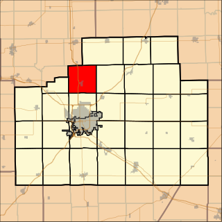
Pontiac Township is located in Livingston County, Illinois. As of the 2010 census, its population was 13,049 and it contained 5,179 housing units.

Sidney Township is a township in Champaign County, Illinois, USA. As of the 2010 census, its population was 1,733 and it contained 715 housing units.

Cedar Township is one of twenty-one townships in Knox County, Illinois, USA. As of the 2010 census, its population was 3,270 and it contained 1,487 housing units. Its name was changed from Cherry Grove Township on June 8, 1853.

Pendleton Township is one of sixteen townships in Jefferson County, Illinois, USA. As of the 2010 census, its population was 1,206 and it contained 461 housing units.

Camargo Township is one of nine townships in Douglas County, Illinois, USA. As of the 2010 census, its population was 3,585 and it contained 1,577 housing units.

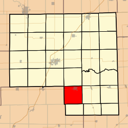
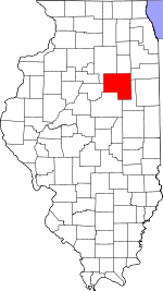
Murdock Township is one of nine townships in Douglas County, in the U.S. state of Illinois. As of the 2010 census, its population was 225 and it contained 126 housing units. It was formed from Camargo and Newman townships on December 7, 1882.

Tuscola Township is one of nine townships in Douglas County, Illinois, USA. As of the 2010 census, its population was 5,259 and it contained 2,459 housing units.

North Fork Township is one of ten townships in Gallatin County, Illinois, USA. As of the 2010 census, its population was 408 and it contained 204 housing units.