Kaka, Arizona

Last updated

Kaka, Arizona
O'odham: Gagka
Maricopa County Arizona Incorporated and Unincorporated areas Kaka Highlighted 0436780.svg
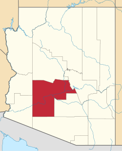
Location in Maricopa County, Arizona
USA Arizona location map.svg
Red pog.svg
Kaka
Usa edcp location map.svg
Red pog.svg
Kaka
Coordinates: 32°30′41″N112°18′59″W / 32.51139°N 112.31639°W / 32.51139; -112.31639
Country United States
State Arizona
County Maricopa
Area
[1]
  Total0.50 sq mi (1.29 km2)
  Land0.50 sq mi (1.29 km2)
  Water0.00 sq mi (0.00 km2)
Elevation
[2]
2,251 ft (686 m)
Population
 (2020) [3]
  Total83
  Density167.00/sq mi (64.48/km2)
Time zone UTC-7 (MST (no DST))
Area code 928
FIPS code 04-36780
GNIS feature ID2582804 [2]

Kaka (O'odham: Gagka, translates as "A Clearing") is a census-designated place (CDP) in Maricopa County, Arizona, United States, located in the Tohono O'odham Nation. The population was 83 at the 2020 census, [3] down from 141 at the 2010 census.

Contents

Toponymy

It has frequently been noted on lists of unusual place names. [4]

Geography

Kaka is in southernmost Maricopa County, nearly touching the border with Pima County. It is 88 miles (142 km) south-southwest of Phoenix, 106 miles (171 km) west-northwest of Tucson, and 67 miles (108 km) northeast of the Mexican border at Lukeville.

Demographics

At the 2020 census there were 83 people and 28 households living in the CDP. [3] [5]

The median household income was $39,573. The per capita income for the CDP was $13,965. [6]

Historical population
CensusPop.Note
2010 141
2020 83−41.1%
U.S. Decennial Census [7]

As of the census [8] of 2010, there were 141 people living in the CDP. The population density was 545.0 people per square mile. The racial makeup of the CDP was 99% Native American and 1% from some other race. 6% of the population were Hispanic or Latino of any race.

Related Research Articles

<span class="mw-page-title-main">Rio Verde, Arizona</span> CDP in Maricopa County, Arizona

Rio Verde is a master-planned community just east of Scottsdale, in Arizona. It is also a census-designated place (CDP) in Maricopa County, Arizona, United States, located in the far, far northeast area of the whole Phoenix Metropolitan Area. The population was 2,210 as of the 2020 census, up from 1,811 at the 2010 census.

<span class="mw-page-title-main">Sun Lakes, Arizona</span> CDP in Maricopa County, Arizona

Sun Lakes is an unincorporated community and census-designated place (CDP) in Maricopa County, Arizona, United States. The population was 14,868 at the 2020 census. Sun Lakes is an active adult community comprising five country club communities in three homeowner associations. These include the gated communities of Oakwood and IronWood (IronOaks), the gated and non-gated communities of Palo Verde and Cottonwood, and the non-gated community of Sun Lakes 1.

<span class="mw-page-title-main">Mojave Ranch Estates, Arizona</span> CDP in Mohave County, Arizona

Mojave Ranch Estates is an unincorporated community and census-designated place (CDP) in Mohave County, Arizona, United States. The population was 53 as of the 2020 census.

<span class="mw-page-title-main">Charleston Park, Florida</span> Census-designated place in Florida, United States

Charleston Park is an unincorporated community and census-designated place (CDP) in Lee County, Florida, United States. The population was 235 at the 2020 census, up from 218 at the 2010 census. It is part of the Cape Coral-Fort Myers, Florida Metropolitan Statistical Area.

<span class="mw-page-title-main">Homestead Base, Florida</span> Census-designated place in Florida

Homestead Base is a census-designated place (CDP) in Miami-Dade County, Florida, United States. The CDP comprises the extent of Homestead Air Reserve Base plus some surrounding land. It is part of the Miami metropolitan area of South Florida. The population was 999 at the 2020 census.

<span class="mw-page-title-main">Ives Estates, Florida</span> Census-designated place in Florida

Ives Estates is a census-designated place (CDP) in Miami-Dade County, Florida. It is part of the Miami metropolitan area of South Florida. The population was 25,005 at the 2020 census, up from 19,525 in 2010.

<span class="mw-page-title-main">Kendall West, Florida</span> Census-designated place in Florida

Kendall West is a census-designated place and unincorporated community in Miami-Dade County, Florida, west of the Florida Turnpike. It is located in the Miami metropolitan area of South Florida. The population was 36,536 at the 2020 census.

<span class="mw-page-title-main">Leisure City, Florida</span> Census-designated place in Florida

Leisure City is an unincorporated community and census-designated place (CDP) in Miami-Dade County, Florida, United States, that includes the smaller, older community of Modello in its northwestern section. The CDP is most notable for the Coral Castle Museum, located in the Modello area. It is located in the Miami metropolitan area of South Florida. The population was 26,324 at the 2020 census, up from 22,655 in 2010.

<span class="mw-page-title-main">Richmond Heights, Florida</span> Census-designated place in Florida

Richmond Heights is a census-designated place (CDP) in Miami-Dade County, Florida, United States. It is part of the Miami metropolitan area of South Florida. The population was 8,944 at the 2020 census.

<span class="mw-page-title-main">Three Lakes, Florida</span> Census-designated place in Florida

Three Lakes is a census-designated place (CDP) and planned community in Miami-Dade County, Florida, United States. It is part of the Miami metropolitan area of South Florida. The population was 16,540 at the 2020 census, up from 15,047 in 2010.

<span class="mw-page-title-main">West Perrine, Florida</span> Census-designated place in Florida

West Perrine is a census-designated place (CDP) in Miami-Dade County, Florida, United States. It is part of the Miami metropolitan area of South Florida. The population was 10,602 at the 2020 census, up from 9,460 in 2010.

<span class="mw-page-title-main">Duck Key, Florida</span> Census-designated place in Florida, United States

Duck Key is a census-designated place and unincorporated community in Monroe County, Florida, United States, on an island of the same name in the middle Florida Keys. The CDP also includes the neighboring island of Conch Key. As of the 2020 census, the CDP had a population of 727, up from 621 in 2010.

Venetian Village is a census-designated place (CDP) in Lake County, Illinois, United States. Per the 2020 census, the population was 2,761.

<span class="mw-page-title-main">South Miami Heights, Florida</span> Census-designated place in Florida

South Miami Heights is a census-designated place (CDP), originally known as Eureka, in Miami-Dade County, Florida. It is part of the Miami metropolitan area of South Florida. The population was 36,770 as of the 2020 census.

<span class="mw-page-title-main">Alice Acres, Texas</span> Place in Texas, United States

Alice Acres is an unincorporated community and census-designated place (CDP) in Jim Wells County, Texas, United States. The population was 465 at the 2020 census.

<span class="mw-page-title-main">Arlington, Arizona</span> CDP in Maricopa County, Arizona

Arlington is an unincorporated community and census-designated place (CDP) in Maricopa County, Arizona, United States, located 43 miles (69 km) west of downtown Phoenix on old U.S 80. It follows the street numbering system of Phoenix. As of the 2020 census, the population was 150, down from 194 at the 2010 census.

<span class="mw-page-title-main">Wintersburg, Arizona</span> CDP in Maricopa County, Arizona

Wintersburg is an unincorporated community and census-designated place in Maricopa County, Arizona, United States, located 48 miles (77 km) west of downtown Phoenix and 17 miles (27 km) west of Buckeye along Salome Highway. It is 4 miles (6 km) south of Exit 98 on Interstate 10. As of the 2020 census, Wintersburg had a population of 51, down from 136 in 2010.

<span class="mw-page-title-main">Komatke, Arizona</span> CDP in Maricopa County, Arizona

Komatke is a census-designated place in Maricopa County, Arizona, United States. The area currently comprising the census-designated place had a population of 1,013 at the 2020 census, up from 821 at the 2010 census. It is located within the Gila River Indian Community. Its name refers to the Sierra Estrella mountain range, which rises just to the southwest of Komatke.

<span class="mw-page-title-main">Gila Crossing, Arizona</span> CDP in Maricopa County, Arizona

Gila Crossing is a census-designated place (CDP) in Maricopa County, Arizona, United States, within the Gila River Indian Community south of Komatke. The population was 636 at the 2020 census.

<span class="mw-page-title-main">St. Johns, Maricopa County, Arizona</span> CDP in Maricopa County, Arizona

St. Johns is a census-designated place (CDP) in Maricopa County, Arizona, United States, located in the Gila River Indian Community. The population was 690 at the 2020 census, up from 476 at the 2010 census.

References

  1. "2021 U.S. Gazetteer Files: Arizona". United States Census Bureau. Retrieved May 16, 2022.
  2. 1 2 U.S. Geological Survey Geographic Names Information System: Kaka, Arizona
  3. 1 2 3 "Kaka CDP, Arizona: 2020 DEC Redistricting Data (PL 94-171): P1. Race". U.S. Census Bureau. Retrieved May 16, 2022.
  4. Parker, Quentin (2010). Welcome to Horneytown, North Carolina, Population: 15: An insider's guide to 201 of the world's weirdest and wildest places. Adams Media. p. x. ISBN   9781440507397.[ permanent dead link ]
  5. "Kaka CDP, Arizona: 2020 DEC Redistricting Data (PL 94-171): H1. Occupancy statistics". U.S. Census Bureau. Retrieved May 16, 2022.
  6. "Kaka, AZ Profile: Facts & Data". Arizona.hometownlocator.com. 2021. Retrieved August 24, 2021.
  7. "Census of Population and Housing". Census.gov. Retrieved June 4, 2016.
  8. "American FactFinder". Archived from the original on July 21, 2011. Retrieved April 23, 2011.