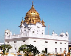
Kartarpur is a town located, just 102 km from Lahore city in the Shakargarh Tehsil, Narowal District in Punjab, Pakistan. Located on the right bank of the Ravi River, it is said to have been founded by the first guru of Sikhism, Guru Nanak, where he established the first Sikh commune.

The Ministry of Defence (MoD) is charged with coordinating and supervising all agencies and functions of the government relating directly to national security and the Indian Armed Forces. The President of India is the ceremonial commander-in-chief of the armed forces of the country. The Ministry of Defence provides policy framework and resources to the armed forces to discharge their responsibility in the context of the country's defence. The Indian Armed Forces and Indian Coast Guard under the Ministry of Defence are primarily responsible for ensuring the territorial integrity of India.

Bengaluru Suburban Railway is an under-construction suburban rail network for the city of Bangalore. A suburban rail system for the city was first proposed in 1983. Since then, several different route proposals were made but no suburban rail project took shape. It was finally approved in the 2019 Railway Budget.

Gurdwara Darbar Sahib Kartarpur, also called Kartarpur Sahib, is a gurdwara in Kartarpur, located in Shakargarh, Narowal District, in the Punjab province of Pakistan. It is built on the historic site where the founder of Sikhism, Guru Nanak, settled and assembled the Sikh community after his missionary travels and lived for 18 years until his death in 1539. It is one of the holiest sites in Sikhism, alongside the Golden Temple in Amritsar and Gurdwara Janam Asthan in Nankana Sahib.
Hili is a village in Hili CD Block in Balurghat subdivision of Dakshin Dinajpur district in the Indian state of West Bengal. It is a border checkpoint on the India-Bangladesh border.

The Bangladesh–India border, known locally as the Radcliffe line (IB), is an international border running between the republics of Bangladesh and India that demarcates the six divisions of Bangladesh and the Indian states.

The Northern Corridor Economic Region, commonly referred to as the Northern Corridor is a development plan encompassing the four northwestern states of Malaysia, namely Perlis, Penang, Kedah and Perak. It was launched in 2007 by the federal government with an aim to transform the region into a sustainable and socio-economically balanced region by 2025. The Northern Corridor Implementation Authority (NCIA) is the statutory body responsible to establishing the NCER's direction, policies and strategies.
The proposed Eastern Economic corridor of India would originate from Paradip port in Odisha province, pass through Jharkhand province, could possibly have an auxiliary loop through Chhattisgarh province, and would terminate at the Integrated Check Post (ICP), Raxaul in Bihar province on the India-Nepal border. This corridor would also link up with North South Fast Track Corridor of Nepal. Beyond Nepal, it would be linked to China through Tibet. A portion of this corridor in Bihar lies along Asian Highway 42 and the Trans Asian Rail Network.
Changrabandha is a census town and a gram panchayat in Mekhliganj CD block in Mekhliganj subdivision of Cooch Behar district in the state of West Bengal, India. It is a border checkpoint on the Bangladesh-India border.

Zokhawthar is a border town in the Champhai district of Mizoram state of India.

The Bharatmala Pariyojna was a project in India implemented by Government of India. It was slated to interconnect 550 District Headquarters through a minimum 4-lane highway by raising the number of corridors to 50 and move 80% of freight traffic to National Highways by interconnecting 24 logistics parks, 66 inter-corridors (IC) of total 8,000 km (5,000 mi), 116 feeder routes (FR) of total 7,500 km (4,700 mi) and 7 northeast Multi-Modal waterway ports. The project also includes the development of tunnels, bridges, elevated corridors, flyovers, overpasses, interchanges, bypasses, ring roads, etc. to provide the shortest, jam-free & optimized connectivity to multiple places, it is a centrally-sponsored and funded Road and Highways project of the Government of India.

The Republic of India shares borders with several sovereign countries; it shares land borders with China, Bhutan, Nepal, Pakistan, Bangladesh, and Myanmar. Bangladesh, Myanmar, and Pakistan share both land borders as well as maritime borders, while Sri Lanka shares only a maritime border through Ram Setu. India's Andaman and Nicobar Islands share a maritime border with Thailand, Myanmar, and Indonesia.

Delhi–Amritsar–Katra Expressway is an approved 670 km (420 mi) long, 4-lane wide controlled-access expressway, which will connect Bahadurgarh border near Delhi with Katra in Jammu and Kashmir via Haryana and Punjab. It will have a spur section which will connect Nakodar with Sri Guru Ram Das Ji International Airport located in Raja Sansi, Amritsar. The 397.7 km (247.1 mi) long Delhi–Katra Expressway is National Expressway 5(NE-5) and 99 km (62 mi) long Nakodar-Amritsar Expressway is National Expressway 5A(NE-5A). Once completed, it will reduce the current Delhi-Katra distance from 727 km (452 mi) to 588 km (365 mi) and the time travel will be reduced from 14 hours to 6 hours, and Delhi-Amritsar distance to 405 km (252 mi) and from the time travel will be reduced from 8 hours to only 4 hours.

The Kartarpur Corridor is a visa-free border crossing and religious corridor, connecting the Gurdwara Darbar Sahib, near Narowal in Pakistan to Gurudwara Dera Baba Nanak, Gurdaspur district, Punjab, India. The crossing allows devotees from India to visit the gurdwara in Kartarpur, Pakistan, 4.7 kilometres from the India–Pakistan border on the Pakistani side without a visa. However, Pakistani Sikhs are unable to use the border crossing, and cannot access Dera Baba Nanak on the Indian side without first obtaining an Indian visa or unless they work there.
Mahadipur is a village in English Bazar CD block in Malda Sadar subdivision of Malda district in the state of West Bengal, India and is a border checkpoint, on the Indian side of the Bangladesh-India border, with Sonamosjid in Chapai Nawabganj District on the Bangladesh side.

The India–Nepal border is an open international boundary running between the republics of India and Nepal. The 1,751 km (1,088.02 mi) long border includes the Himalayan territories as well as Indo-Gangetic Plain of the subcontinent. The current border was delimited after the Sugauli treaty of 1816 between Nepal and the British Raj. Following Indian independence, the prevailing border was recognised as the international border between the Kingdom of Nepal and the Dominion of India.
This is a list of the land border crossings of Pakistan with its four neighbours, namely Afghanistan, China, India and Iran.

Shrikhandi Bhittha or Bhitthamore is an Indian village in the Mithila region of Bihar, situated near the Indo-Nepal border, on the banks of the perennial Ratnawati (Raato) river.

Dineshchandra R. Agrawal Infracon Private Limited or DRA Infracon is an infrastructure development and construction company based at Ahmedabad in Gujarat, India. It was founded by Mr. Dineshchandra Rameshwarji Agrawal at Deesa in Banaskantha district of Gujarat in 1972. DRA Infracon got incorporated in the Ministry of Corporate Affairs on 7 November 2003.

The Benapole Border Crossing also known as the Petrapole Crossing is an international border crossing between Benapole, Jessore, Bangladesh, and Petrapole, North 24 Parganas, West Bengal, India.


