A governorate was a major and principal administrative subdivision of the Russian Empire. After the Bolshevik Revolution in 1917, governorates remained as subdivisions in the Byelorussian, Russian and Ukrainian Soviet republics, and in the Soviet Union from its formation in 1922 until 1929. The term is also translated as government or province. A governorate was headed by a governor, a word borrowed from Latin gubernator, in turn from Greek kyvernítis.
The Saint Petersburg Governorate was a province (guberniya) of the Russian Empire, with its capital in Saint Petersburg. The governorate was composed of 44,613 square kilometres (17,225 sq mi) of area and 2,112,033 inhabitants. It was bordered by Estonian and Livonian Governorates to the west, Pskov Governorate to the south, Novgorod Governorate to the east, Olonets Governorate to the northeast, and Vyborg Governorate of the Grand Duchy of Finland to the north. The governorate covered most of the areas of modern Leningrad Oblast and Ida-Viru, Jõgeva, Tartu, Põlva, and Võru counties of Estonia.

Taurida Governorate was an administrative-territorial unit (guberniya) of the Russian Empire. It included the territory of the Crimean Peninsula and the mainland between the lower Dnieper River with the coasts of the Black Sea and Sea of Azov. It formed after Taurida Oblast was abolished in 1802 during the course of Paul I's administrative reform of the territories of the former Crimean Khanate which were annexed by Russia in 1783. The governorate's centre was the city of Simferopol. The name of the province was derived from Taurida, a historical name for Crimea.

The Baku Governorate, known before 1859 as the Shemakha Governorate, was a province (guberniya) of the Caucasus Viceroyalty of the Russian Empire, with its center in the booming metropolis and Caspian Sea port of Baku. Area (1897): 34,400 sq. versts, population (1897): 789,659. The Baku Governorate bordered Persia to the south, the Elizavetpol Governorate to the west, the Dagestan Oblast to the north, and the Baku gradonachalstvo to the east on the Absheron Peninsula.

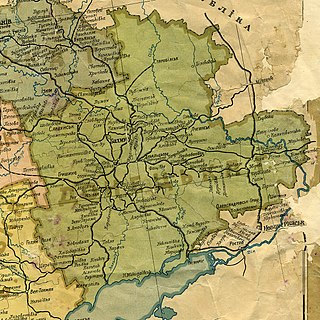
Kherson Governorate, known until 1803 as Nikolayev Governorate, was an administrative-territorial unit (guberniya) of the Russian Empire, with its capital in Kherson. It encompassed 71,936 square kilometres (27,775 sq mi) in area and had a population of 2,733,612 inhabitants. At the time of the census in 1897, it bordered Podolia Governorate to the northwest, Kiev Governorate to the north, Poltava Governorate to the northeast, Yekaterinoslav Governorate to the east, Taurida Governorate to the southeast, Black Sea to the south, and Bessarabia Governorate to the west. It roughly corresponds to what is now most of Mykolaiv, Kirovohrad and Odesa Oblasts in Ukraine and some parts of Kherson and Dnipropetrovsk Oblasts.

The Vilna Governorate was a province (guberniya) of the Northwestern Krai of the Russian Empire. In 1897, the governorate covered an area of 41,907.9 square kilometres (16,180.7 sq mi) and had a population of 1,591,207 inhabitants. The governorate was defined by the Minsk Governorate to the south, the Grodno Governorate to the southwest, the Suwałki Governorate to the west, the Kovno and Courland Governorates to the north, and the Vitebsk Governorate to the east. The capital was located in Vilna (Vilnius). The city also served as the capital of Vilna Governorate-General, which existed until 1912. The area roughly corresponded to the Vilnius Region, which was later occupied by Germany, Bolsheviks, and Poland.

Kholm Governorate was an administrative-territorial unit (guberniya) of the Russian Empire, with its capital in Kholm (Chełm).

Łomża Governorate was an administrative-territorial unit (guberniya) of Congress Poland of the Russian Empire, with its capital in Łomża.
Little Russia Governorate or Malorossiya Governorate was an administrative-territorial unit (guberniya) of the Russian Empire that encompassed most of modern-day northeastern Ukraine, then given the historical designation of Little Russia, and adjacent regions in Russia.

Poltava Governorate was an administrative-territorial unit (guberniya) of the Russian Empire. It included the territory of left-bank Ukraine and was officially created in 1802 from the disbanded Little Russia Governorate, which was split between Chernigov and Poltava Governorates with its capital in Poltava.

Tiflis Governorate was a province (guberniya) of the Caucasus Viceroyalty of the Russian Empire with its administrative centre in Tiflis. In 1897, it constituted 44,607 square kilometres (17,223 sq mi) in area and had a population of 1,051,032 inhabitants. Tiflis Governorate bordered Elizavetpol Governorate to the southeast, Erivan Governorate to the south, Kars Oblast to the southwest, Batum Oblast to the west, Kutaisi Governorate to the northwest, Terek Oblast to the north, Dagestan Oblast to the northeast, and after 1905, the Zakatal Okrug to the east. The governorate covered areas of central and southeastern Georgia, the partially recognised state of South Ossetia, most of the Lori Province of Armenia, small parts of northwestern Azerbaijan, and a minuscule southern part of Ingushetia of Russia.

Kharkov Governorate was an administrative-territorial unit (guberniya) of the Russian Empire founded in 1835. It embraced the historical region of Sloboda Ukraine. From 1765 to 1780 and from 1796 to 1835 the governorate was called Sloboda Ukraine Governorate. In 1780–1796 there existed the Kharkov Viceroyalty.

Shemakha Governorate was an administrative-territorial unit (guberniya) of the Caucasus Viceroyalty of the Russian Empire, with its administrative center in Shemakha (Shamakhi). Following the earthquake of 1859, the capital was transferred and the province became known as the Baku Governorate.

Novorossiya Governorate was an administrative-territorial unit (guberniya) of the Russian Empire, which existed in 1764–1783 and again in 1796–1802. It was created and governed according to the "Plan for the Colonization of New Russia Governorate" issued by the Russian Senate. It became the first region in Russia where Catherine the Great allowed foreign Jews to settle.

Chernihiv Governorate was an administrative-territorial unit of the Ukrainian State and the Ukrainian SSR, existing from 1918 to 1925. It was inherited from the Russian system of territorial subdivisions that existed prior to World War I. Specifically, Chernigov Governorate was an administrative-territorial unit (guberniya) of the Russian Empire. It included the territory of the left-bank Ukraine and was officially created in 1802 from Malorossiya Governorate with its capital in Chernigov (Chernihiv). Little Russia Governorate was transformed into the General Government of Little Russia and consisted of Chernigov Governorate, Poltava Governorate, and later Kharkov Governorate.

The Kutaisi or Kutais Governorate was a province (guberniya) of the Caucasus Viceroyalty of the Russian Empire. It roughly corresponded to most of western Georgia throughout most of its existence, and most of the Artvin Province of Turkey between 1878 and 1903. Created out of part of the former Georgia-Imeretia Governorate in 1846, the governorate also included Akhaltsikhe uezd before its cession to the Tiflis Governorate in 1867. The Kutaisi Governorate bordered the Sukhumi Okrug to the northwest, the Kuban Oblast to the north, the Terek Oblast to the northeast, the Tiflis Governorate to the southeast, the Batum Oblast to the southwest, and the Black Sea to the west. The governorate was eponymously named for its administrative center, Kutais.

Kiev Governorate was an administrative-territorial unit (guberniya) of the Tsardom of Russia and the Russian Empire. It was established in December 1708 as one of the eight guberniyas first created during the reforms of Peter the Great.
Odesa Governorate, was a territorial division of the Ukrainian SSR (Ukraine) that was created in January 1920 by a decision of the All-Ukrainian Revolutionary Committee. The new governorate was initially created from the western part of the Kherson Governorate.
Donets Governorate was a governorate of the Ukrainian SSR (Ukraine) that existed between 1919 and 1925.

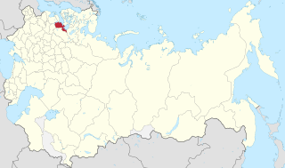
Nizhny Novgorod Governorate was an administrative-territorial unit (guberniya) of the Russian Empire, Russian Republic, and the Russian SFSR, roughly corresponding to the Upper and Middle Volga region and what is now most of the Nizhny Novgorod Oblast. In the early of 20th Century, Nizhny Novgorod Governorate bordered Kostroma and Vyatka governorates to the north, Vladimir Governorate to the west, Kazan and Simbirsk governorates to the east, and Penza with Tambov governorates to the south.