The London commuter belt is a metropolitan area that includes London and its surrounding commuter zone (the area in which it is practicable to commute to work in London). It is also known as the London metropolitan area, [1] or Southeast metropolitan area. [2]
A metropolitan area is a region consisting of a densely populated urban core and its less-populated surrounding territories, sharing industry, infrastructure, and housing. A metro area usually comprises multiple jurisdictions and municipalities: neighborhoods, townships, boroughs, cities, towns, exurbs, suburbs, counties, districts, states, and even nations like the eurodistricts. As social, economic and political institutions have changed, metropolitan areas have become key economic and political regions.
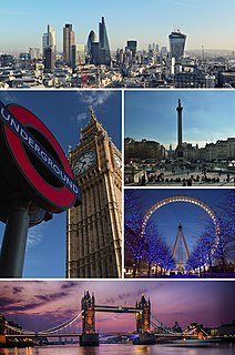
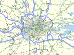
London is the capital and largest city of England and the United Kingdom. Standing on the River Thames in the south-east of England, at the head of its 50-mile (80 km) estuary leading to the North Sea, London has been a major settlement for two millennia. Londinium was founded by the Romans. The City of London, London's ancient core − an area of just 1.12 square miles (2.9 km2) and colloquially known as the Square Mile − retains boundaries that follow closely its medieval limits. The City of Westminster is also an Inner London borough holding city status. Greater London is governed by the Mayor of London and the London Assembly.
Commuting is periodically recurring travel between one's place of residence and place of work, or study, and in doing so exceed the boundary of their residential community. It sometimes refers to any regular or often repeated traveling between locations, even when not work-related. A distinction is also often made between commuters who commute daily or weekly between their residence to work place, often being suburbs to cities, and are therefore considered respectively local or long-distance commuters.
The most up-to-date population figures from Eurostat show that the London metropolitan area is the largest in the EU with a population of 14,257,962 (in 2018). [3]
Eurostat is a Directorate-General of the European Commission located in Luxembourg. Its main responsibilities are to provide statistical information to the institutions of the European Union (EU) and to promote the harmonisation of statistical methods across its member states and candidates for accession as well as EFTA countries. The organisations in the different countries that cooperate with Eurostat are summarised under the concept of the European Statistical System.
The boundaries are not fixed; they expand as transport options improve and affordable housing moves further away from city centre. [4] The belt currently covers much of the South East region and part of the East of England region, including the home counties of Hertfordshire, Buckinghamshire, Berkshire, Surrey, Kent and Essex, and, by several definitions, Hampshire, West Sussex, East Sussex and Bedfordshire.
South East England is the most populous of the nine official regions of England at the first level of NUTS for statistical purposes. It consists of Berkshire, Buckinghamshire, East Sussex, Hampshire, the Isle of Wight, Kent, Oxfordshire, Surrey and West Sussex. As with the other regions of England, apart from Greater London, the south east has no elected government.
The East of England is one of nine official regions of England at the first level of NUTS for statistical purposes. It was created in 1994 and was adopted for statistics from 1999. It includes the ceremonial counties of Bedfordshire, Cambridgeshire, Essex, Hertfordshire, Norfolk and Suffolk. Essex has the highest population in the region.
The home counties are the counties of England that surround London. The counties generally included are Berkshire, Buckinghamshire, Essex, Hertfordshire, Kent, Surrey, and Sussex. Other counties more distant from London—such as Bedfordshire, Cambridgeshire, Hampshire and Oxfordshire—are also sometimes regarded as home counties due to their proximity to London and their connection to the London regional economy.
The population of Greater London and those counties adjacent to the green belt was 18,868,800 in 2011. Much of the undeveloped part of this area lies within the designated Metropolitan Green Belt, which covers nearly all of Surrey, eastern Berkshire, southern Buckinghamshire, southern and mid Hertfordshire, southern Bedfordshire, south-west Essex, and western Kent. In addition, three Areas of Outstanding Natural Beauty (the Chiltern Hills, Surrey Hills and North Downs AONBs) surrounding the Thames basin are within the commuter belt.
The Metropolitan Green Belt is a statutory green belt around London, England. It comprises parts of Greater London and the six adjoining "home counties", parts of two of the three districts of the small county of Bedfordshire and a small area in Copthorne, Sussex. As of 2017/18, Government statistics show the planning designation covered 513,860 hectares of land.
Surrey is a county in South East England which borders Kent to the east, West Sussex to the south, Hampshire to the west, Berkshire to the north-west, and Greater London to the north-east.
Berkshire is a county in South East England. One of the home counties, Berkshire was recognised by the Queen as the Royal County of Berkshire in 1957 because of the presence of Windsor Castle, and letters patent were issued in 1974. Berkshire is a county of historic origin, a ceremonial county and a non-metropolitan county without a county council. The county town is Reading.
The London Travel to Work Area, defined by the Office for National Statistics as the area for which "of the resident economically active population, at least 75% actually work in the area, and also, that of everyone working in the area, at least 75% actually live in the area." [5] has a population of 9,294,800 (2005 estimate). [6]
The Office for National Statistics is the executive office of the UK Statistics Authority, a non-ministerial department which reports directly to the UK Parliament.
There are 17 local government districts that share a boundary with Greater London, in the East and South East regions. Most districts are entirely, or have sections, within the M25 motorway or are within 15–20 miles (24–32 km) of Charing Cross.
The M25 or London Orbital Motorway is a major road encircling almost all of Greater London, England. It is one of the most important roads in Britain, one of the busiest, and on opening was the longest orbital or ring road in Europe at 117 miles (188 km). The Dartford Crossing (A282) is part of the orbital route but is not part of the motorway.
Charing Cross is a junction in London, England, where six routes meet. Clockwise from north these are: the east side of Trafalgar Square leading to St Martin's Place and then Charing Cross Road; the Strand; Northumberland Avenue; Whitehall; The Mall leading to Admiralty Arch and Buckingham Palace; and two short roads leading to Pall Mall.
Adjacent districts often share characteristics of Outer London, such as forming part of the continuous urban sprawl, being served by the London Underground, being covered by the London telephone area code, (until 2000) forming part of the Metropolitan Police District and having a relatively high employed population working in London.
Larger Urban Zone is a definition created by Eurostat that measures the population and expanse of metropolitan areas across European countries. The population of London's Larger Urban Zone is 11.9 million (2004), [7] ranking it as the largest metropolitan area in the European Union. The districts that are considered parts of this Larger Urban Zone are listed here: [8] no district in Bedfordshire, Hampshire, or Sussex is included. Several large conurbations fall just outside the zone: Reading, Luton, High Wycombe and significant parts of the Aldershot and Crawley Urban Areas.
Region | County | Districts within the Zone | Districts outside the Zone |
---|---|---|---|
East | Hertfordshire | North Hertfordshire | |
Essex | |||
South East | Kent | ||
Surrey | |||
Berkshire | |||
Buckinghamshire |
The following table lists urban areas (also known as built-up areas) considered part of the London Commuter Belt with populations over 20,000. [9] [10] The commuter belt contains all urban areas within an approximate 40 mile (64 km) radius of Charing Cross. Some of the outermost towns include Aylesbury, Reading, Aldershot and Maidstone. [11] [12] [13]
Some estate agents, including James Pendleton [15] and Savills [16] have defined a 'second commuter belt' further out of London and the home counties. The definition includes places up to approximately 55 miles (89 km) out of central London including Oxford, Hastings, Margate, Milton Keynes and Brighton.
Buckinghamshire, abbreviated Bucks, is a ceremonial county in South East England which borders Greater London to the south east, Berkshire to the south, Oxfordshire to the west, Northamptonshire to the north, Bedfordshire to the north east and Hertfordshire to the east.
The West Midlands conurbation is the large conurbation that includes the cities of Birmingham and Wolverhampton and the large towns of Sutton Coldfield, Dudley, Walsall, West Bromwich, Solihull, Stourbridge and Halesowen in the English West Midlands.
The counties of England are areas used for different purposes, which include administrative, geographical, cultural and political demarcation. The term 'county' is defined in several manners and can apply to similar or the same areas used by each of these demarcation structures. These different types of county each have a more formal name but are commonly referred to just as 'counties'. The current arrangement is the result of incremental reform.
The Metropolitan Borough of Walsall is a local government district in the West Midlands, England, with the status of a metropolitan borough. It is named after its largest settlement, Walsall, but covers a larger area which also includes Aldridge, Bloxwich, Brownhills, Darlaston, Pelsall and Willenhall. The borough had an estimated population of 254,500 in 2007.
In the Nomenclature of Territorial Units for Statistics (NUTS) codes of the United Kingdom (UK), the three levels are:
Greater Helsinki is the metropolitan area surrounding Helsinki, the capital city of Finland. It includes the smaller Capital Region urban kernel.
The Nottingham Built-up Area (BUA), Nottingham Urban Area, or Greater Nottingham is an area of land defined by the Office for National Statistics as which is built upon, with nearby areas linked if within 200 metres - see the List of urban areas in the United Kingdom article for a broader definition. It consists of the city of Nottingham and the adjoining urban areas of Nottinghamshire and Derbyshire, in the East Midlands of England. It had a total population of 729,977 at the time of the 2011 census. This was an increase of almost 10% since the 2001 census recorded population of 666,358,, due to population increases, reductions and several new sub-divisions.
Greater Glasgow is an urban settlement in Scotland consisting of all localities which are physically attached to the city of Glasgow, forming with it a single contiguous urban area. It does not relate to municipal government boundaries and its territorial extent is defined by the General Register Office for Scotland, which determines settlements in Scotland for census and statistical purposes. Greater Glasgow had a population of 1,199,629 at the time of the 2001 UK Census making it the largest urban area in Scotland and the fifth-largest in the United Kingdom.
South Hampshire is a term used mainly to refer to the metropolitan area formed by the cities of Portsmouth and Southampton and their suburbs and commuter towns, in southern Hampshire, England. The area had a population of around 1 million based on the 2001 census, and estimated population of over 1.5 million in 2013. It is the most populated part of South East England, excluding London. The area is sometimes referred to as Solent City but the term is controversial.
The Farnborough/Aldershot built-up area or Blackwater Valley Conurbation or Aldershot Urban Area is the name used by the ONS to refer to the loose conurbation on the border between Surrey, Berkshire and Hampshire in England. They give it a population of 252,937 in 2011 up by around 4% from the 2001 figure of 243,344. This makes it the 29th largest built up area in England and Wales.
The larger urban zone (LUZ), or Functional Urban Area (FUA), is a measure of the population and expanse of metropolitan areas in Europe. It consists of a city and its commuting zone.
The Luton/Dunstable Urban Area according to the Office for National Statistics is the conurbation including the settlements of Luton, Dunstable and Houghton Regis, in Bedfordshire, East of England.
A Travel to Work Area or TTWA is a statistical tool used by UK Government agencies and local authorities, especially by the Department for Work and Pensions and Jobcentres, to indicate an area where the population would generally commute to a larger town, city or conurbation for the purposes of employment.
The Barcelona metropolitan area is a metropolitan area in Catalonia, north of Spain, centered on the city of Barcelona. With a population of around 5 million, it's the most populous metropolitan area on the Mediterranean coast, and one of the largest in Europe.
The following outline is provided as an overview of and topical guide to England:
Greater London is a ceremonial county of England that forms the London region. This region forms the administrative boundaries of London and is organised into 33 local government districts—the 32 London boroughs and the City of London, which is located within the region but is separate from the county. The Greater London Authority, based in Southwark, is responsible for strategic local government across the region and consists of the Mayor of London and the London Assembly. The City of London Corporation is the principal local authority for the City of London, with a similar role to that of the 32 London borough councils.