Meerut Airport

Last updated
Meerut Airport
मेरठ हवाई अड्डा
Summary
Airport type Public
Owner Airports Authority of India [1]
Serves Meerut
Location Meerut, Uttar Pradesh, India
Elevation  AMSL 732 ft / 223 m
Coordinates 28°54′18″N077°40′37″E / 28.90500°N 77.67694°E / 28.90500; 77.67694 Coordinates: 28°54′18″N077°40′37″E / 28.90500°N 77.67694°E / 28.90500; 77.67694
Map
India Uttar Pradesh location map.svg
Airplane silhouette.svg
Meerut Airport
Runways
Direction Length Surface
ft m
11/29 5,124 1,562 Asphalt

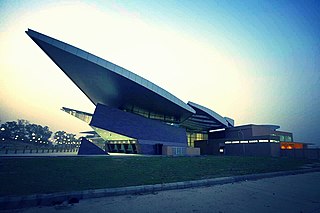
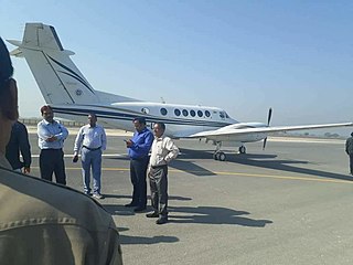
Meerut Airport or B.R. Ambedkar Airport is situated at Partapur, 9 km south of Village Gagol Meerut, in Uttar Pradesh, India. The Airport, spread across 47 acres, is used for regional flights. [2] The Government of Uttar Pradesh signed a MoU with the Airports Authority of India (AAI) in February 2014 for the development of the airport. [1]

Meerut Metropolitan City in Uttar Pradesh, India

Meerut, is a city in the Indian state of Uttar Pradesh. It is an ancient city, with settlements dating back to the Indus Valley civilisation having been found in and around the area. The city lies 70 km (43 mi) northeast of the national capital New Delhi, and 430 km (270 mi) northwest of the state capital Lucknow.

Uttar Pradesh State in India

Uttar Pradesh is a state in northern India. With over 200 million inhabitants, it is the most populous state in India as well as the most populous country subdivision in the world. It was created on 1 April 1937 as the United Provinces of Agra and Oudh during British rule, and was renamed Uttar Pradesh in 1950. The state is divided into 18 divisions and 75 districts with the capital being Lucknow. The main ethnic group is the Hindavi people, forming the demographic plurality. On 9 November 2000, a new state, Uttarakhand, was carved out from the state's Himalayan hill region. The two major rivers of the state, the Ganga and Yamuna, join at Allahabad (Prayagraj) and then flow as the Ganga further east. Hindi is the most widely spoken language and is also the official language of the state.

Airports Authority of India agency that runs airports in India

The Airports Authority of India or AAI is a statutory body working under the Ministry of Civil Aviation, Government of India is responsible for creating, upgrading, maintaining and managing civil aviation infrastructure in India. It provides Communication Navigation Surveillance / Air Traffic Management (CNS/ATM) services over Indian airspace and adjoining oceanic areas. It also manages a total of 126 Airports, including 11 International Airports, 11 Customs Airports, 89 Domestic Airports and 26 Civil enclaves at Military Airfields. AAI also has ground installations at all airports and 25 other locations to ensure safety of aircraft operations. AAI covers all major air-routes over Indian landmass via 29 Radar installations at 11 locations along with 700VOR/DVOR installations co-located with Distance Measuring Equipment (DME). 52 runways are provided with Instrument landing system (ILS) installations with Night Landing Facilities at most of these airports and Automatic Message Switching System at 15 Airports.

The AAI had initially proposed the development of the airport to provide better air connectivity in the western parts of the state, which had already been assessed for up-gradation to cater to scheduled operations. AAI presented a master plan to the state government in April 2012 seeking the transfer of the airstrip and additional land free of cost and free from all encumbrances. The then Union civil aviation minister Ajit Singh had urged the State government in November 2012 to handover the airstrip and an additional 427 acres to AAI for development. [3] The Uttar Pradesh cabinet approved to hand over the airstrip AAI in September 2013. [4]

The state had earlier planned to build a new airport of international standard on same location. The state government had issued a notice for appointing a consultant to prepare a comprehensive feasibility project report, a bid document and the concession agreement for the proposed airport. The project would be implemented through public-private partnership on a design, build, finance, operate and transfer basis. The State Government decided to have an international airport at Meerut based on a study conducted on the area’s traffic density. Following this, the Ministry of Civil Aviation gave its in-principle approval. The need for a second airport on the fringes of the national capital region has been a long-standing demand of the Uttar Pradesh government, especially in view of the burgeoning air traffic at Delhi airport. The proposed airport will not only cater to the industrial towns of western Uttar Pradesh but would relieve neighbouring Uttarakhand. [2]

Uttarakhand State in Northern India

Uttarakhand, formerly known as Uttaranchal, is a state in the northern part of India. It is often referred to as the Devabhumi due to a large number of Hindu temples and pilgrimage centres found throughout the state. Uttarakhand is known for the natural environment of the Himalayas, the Bhabhar and the Terai. On 9 November 2000, Uttarakhand became the 27th state of the Republic of India, being created from the Himalayan districts of Uttar Pradesh. It borders Tibet Autonomous Region of China to the north; the Sudurpashchim Pradesh of Nepal to the east; the Indian states of Uttar Pradesh to the south and Himachal Pradesh to the west and north-west. The state is divided into two divisions, Garhwal and Kumaon, with a total of 13 districts. The interim capital of Uttarakhand is Dehradun, the largest city of the state, which is a railhead. The High Court of the state is located in Nainital.

Related Research Articles

Biju Patnaik Airport airport

Biju Patnaik International Airport, also known as the Bhubaneswar Airport, is the primary international airport serving Bhubaneswar, the capital city of Odisha. It is situated around 4 kilometres (2.5 mi) south-west from Bhubaneswar railway station and 6 kilometres (3.7 mi) away from the city center. Named after the former chief minister of Odisha, Biju Patnaik, a famed aviator and freedom fighter, it is the 15th busiest airport in India & 11th busiest among the airports maintained by Airports Authority of India, registering a 39.4% growth in traffic over the previous year.

Ajit Singh is an Indian politician. He is the founder and chief of the Rashtriya Lok Dal, a political party recognized in western part of state of Uttar Pradesh, and son of former Prime Minister of India late Chaudhary Charan Singh. He was born on 12 February 1939 at village Bhadola in Meerut, Uttar Pradesh.

Along Airport airport in India

Along Airport also known as Aalo Airport is located at Along in the state of Arunachal Pradesh, India.

Pasighat Airport airport in India

Pasighat Airport is located at Pasighat in the state of Arunachal Pradesh, India.

Bijapur Airport airport

Bijapur Airport is a planned greenfield airport that will serve the city of Bijapur in Karnataka, India. The airport will be built by the Airports Authority of India (AAI) on 727-acre (2.94 km2) of land at Madabhavi village near Bijapur.

Devi Ahilya Bai Holkar Airport Airport of India

Devi Ahilya Bai Holkar Airport is an international airport that principally serves Indore and adjacent regions in the Indian State of Madhya Pradesh. It is the busiest airport in Central India and is located 8 km west of Indore. According to the statistics released by the Airports Authority of India, the agency responsible for the maintenance and management of the airport, it is the 22nd busiest airport in India by passenger traffic. The airport is named after Maharani Ahilya Bai Holkar of Indore, belonging to the Holkar dynasty of the Maratha Empire. Devi Ahilyabai Holkar Airport, Indore has been adjudged as the best airport in under 2 million annual passenger footfall category in Asia Pacific region in the Airports Council International (ACI)'s airport service quality (ASQ) rankings for the year 2017. The World Book of Records, UK has bestowed Worlds Standardization Certification to Devi Ahilya Bai Holkar Airport, Indore for the achievement of ACI Award 2017 on 9 April 2018. Since 24 March 2018 it has started operations 24*7 with night landing facilities.

Faizabad Airport airport in India

Faizabad Airport is an upcoming airport in Faizabad city ment to serve legendary city of Ayodhya by upgrading existing government airstip. It is situated between the NH 27 and NH 330 at Sultanpur Naaka, Faizabad in the Indian state of Uttar Pradesh. The State Government signed a memorandum of understanding with the Airports Authority of India (AAI) in February 2014 for the development of the airport.

The Jewar Airport is a proposed airport to be constructed in Jewar in Gautam Budh Nagar district of Uttar Pradesh. The Yamuna Expressway Industrial Development Authority (YEIDA) will be the implementing agency on behalf of the Uttar Pradesh State Government. The airport is to be developed on a Public Private Partnership model (PPP) The airport, expected to be completed by 2022, will be able to handle 5 million passengers per annum (MPA) initially and up to 60 MPA after expansion over 30 years.

Jharsuguda Airport airport in India

Jharsuguda Airport also known as Veer Surendra Sai Airport is located 5 kilometers north-east of Jharsuguda &

Chaudhary Charan Singh International Airport airport in India

Chaudhary Charan Singh International Airport is an international airport serving Lucknow, the capital of the Indian state of Uttar Pradesh. It is situated in the Amausi area of the city, and was earlier known as Amausi Airport before being renamed after Chaudhary Charan Singh, the fifth prime minister of India.

Jhansi Airport airport in India

Jhansi Airport is an upcoming airport, currently used as a military airstrip situated in Jhansi city in the Bundelkhand region of Indian state of Uttar Pradesh, run by the Army Aviation Corps. Airport is developing by upgrading the existing government airstip. Efforts are on to have a civil enclave at the airport. The airport covers an area of 198 acres.

Kushinagar Airport Airport in India

Kushinagar Airport is an upcoming airport situated in Kasia, Kushinagar district and is 52 km east of Gorakhpur, in Kushinagar district in Uttar Pradesh, India. The airstrip spans 97 acres, has a small apron of 145 metres by 46 metres and handles small aircraft.

Andhau Airstrip airport in India

Andhau Airstrip, Ghazipur is an airstrip, situated in Ghazipur in Uttar Pradesh, India. It is located on the Ghazipur-Mau Road, 7 kilometres from Ghazipur. The airstrip is owned by the State Government and currently used for VIP charters only.

Moradabad Airport airport in India

Moradabad Airport is an upcoming airport in Moradabad, situated midway between Moradabad and Rampur city on National Highway 9 in Indian state of Uttar Pradesh. It is developing by upgrading the existing government airstip. The Government of Uttar Pradesh signed a MoU with the Airports Authority of India (AAI) in February 2014 for the development of this airstrip.

Fursatganj Airfield is an airfield situated at Fursatganj of Amethi district in the Indian state of Uttar Pradesh.

Hisar Airport airport in India

Hisar Airport is a current-public domestic and proposed-international airport, MRO, and aero manufacturing industrial zone spread across 4,194 acres (1,697 ha), serving the National Capital Region Counter Magnet City (NCRCMS) of Hisar in Haryana state of India. Located 5 kilometres (3.1 mi) north-east of the city center, it is 165 kilometres (103 mi) from Indira Gandhi International Airport, Delhi and 280 kilometres (170 mi) from the capital's Chandigarh International Airport. To develop this into an international airport the provision of INR 50 crore in 2016-17, INR 50 crore in 2017-18 and INR 120 crore in 2018-19 were made by the Haryana govt.

Maharashtra is a state in the western region of India. It is the second most populous state and third largest state by area in India. Maharashtra is bordered by the Arabian Sea to the west, Gujarat and the Union territory of Dadra and Nagar Haveli to the northwest, Madhya Pradesh to the north and northeast, Chhattisgarh to the east, Karnataka to the south, Telangana to the southeast and Goa to the southwest. The state covers an area of 307,731 km2 (118,816 sq mi) or 9.84% of the total geographical area of India.

The NCR Proposed Transport Plan is a plan for the development of the transport network across the National Capital Region in India.

Marhamtabad Airstrip

Marhamtabad Airstrip is an airstrip situated at Marhamtabad in Kanpur Dehat of the Indian state of Uttar Pradesh. It is owned by Uttar Pradesh Government.

References

  1. 1 2 "MoU Signed for Development of Airports in UP". Press Information Bureau. 24 February 2014. Retrieved 28 February 2014.
  2. 1 2 "Meerut airport to be upgraded to int'l levels". www.financialexpress.com, Thursday, Oct 15, 2009 at 2257 hrs IST.
  3. "Ajit Singh seeks eerut Airport for AAI". Business Standard. 15 October 2009.
  4. "Shelved by Maya, Akhilesh nod to develop Meerut airstrip as airport". The Indian Express. 4 September 2013. Retrieved 28 February 2014.