
Gambo is a town and designated place in the Canadian province of Newfoundland and Labrador. Located in the northeastern portion of the island of Newfoundland on Freshwater Bay, it is in Division No. 7.
Norris Arm is a town in north-central Newfoundland, Newfoundland and Labrador, Canada. It is in Division No. 6, on the Bay of Exploits.
Division No. 8 is a census division on the north coast of the island of Newfoundland in the province of Newfoundland and Labrador, Canada. It has a land area of 9,314.57 km² and had a population of 33,940 at the 2016 census. Its largest communities are the towns of Lewisporte, Springdale, and Twillingate.

Peterview is a town located in the Exploits Valley area of central Newfoundland and Labrador, Canada, where Peters River empties into the Bay of Exploits, just south of Botwood, off Route 350.

Division No. 6 is a census division in the central part of the island of Newfoundland in the province of Newfoundland and Labrador, Canada. It is divided into 16 parts; 12 towns and four unorganized subdivisions.
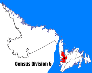
Census Division No. 5 is a Statistics Canada statistical division composed of the areas of the province of Newfoundland and Labrador called Humber Valley, Bay of Islands, and White Bay. It covers a land area of 10,365.63 km², and had a population of 42,014 according to the 2016 census.
Colinet is an incorporated town located on the northwest arm of St. Mary's Bay in Newfoundland and Labrador, Canada.

Campbellton is a small lumbering and fishing community located on the island of Newfoundland at Indian Arm, Notre Dame Bay. The community was originally named Indian Arm due to a Beothuk village located on the nearby Indian Arm River. It was renamed to Campbellton in honor of the sawmill manager John Campbell.
Cobb's Arm is a local service district and designated place in the Canadian province of Newfoundland and Labrador on New World Island. It is located about 8 km outside Newville and leads to other communities such as Pikes Arm and Toogood Arm.

Cox's Cove is a town in the Canadian province of Newfoundland and Labrador. The town had a population of 664 in the Canada 2021 Census. The small community is mainly based on the fishery, mink farm, and construction industries.
Jackson's Arm is a town in the Canadian province of Newfoundland and Labrador, located on White Bay. It was settled by John Wicks of Christchurch, England, around 1870. The Post Office was established in 1892 and the first Postmistress was Belinda Peddle. The town had a population of 435 in 1956 and 277 as of the 2021 Canadian census. The primary industry of the town is fishing. In 2012, the local fish plant closed.
Ming's Bight is a town in the Canadian province of Newfoundland and Labrador. The town had a population of 298 in 2021 Census, down from 319 in the Canada 2016 Census.
Northern Arm is a town in the Canadian province of Newfoundland and Labrador. The town had a population of 371 in the Canada 2021 Census.
Parker's Cove or Parkers Cove is a town in the Canadian province of Newfoundland and Labrador. The town had a population of 233 in the Canada 2021 Census, a drop from 248 in 2016.
Woodstock is a town in the Canadian province of Newfoundland and Labrador. The town had a population of 195 in 2021, up from 190 in the Canada 2016 Census.
Old Shop is a local service district and designated place in the Canadian province of Newfoundland and Labrador. It is on the western side of the Dildo Arm, at the southern end of Trinity Bay. It is northwest of South Dildo, across the Dildo Arm from Dildo proper.
Brown's Arm is a local service district and designated place in the Canadian province of Newfoundland and Labrador
Roddickton-Bide Arm is a town located in the northern peninsula of the island of Newfoundland within the province of Newfoundland and Labrador. It was formed on January 1, 2009 through the amalgamation of the former towns of Roddickton and Bide Arm.
Norris Arm North is a local service district and designated place in the Canadian province of Newfoundland and Labrador. The place is also known as Alderburn. It was originally a fishing and farming settlement.
Pensons Arm is a local service district and designated place in the Canadian province of Newfoundland and Labrador. Pensons Arm, is a coastal village in Labrador, 20 km southeast of Charlottetown. It has a population of 43 in the 2021 census.
