
The Danville Micropolitan Statistical Area is a Micropolitan Statistical Area (μSA) in Virginia as defined by the United States Office of Management and Budget (OMB). As of the 2010 census, the μSA had a population of 106,561

The Houghton Micropolitan Statistical Area, as defined by the United States Census Bureau, is an area consisting of two counties in the Upper Peninsula of Michigan, specifically the Keweenaw Peninsula, anchored by the city of Houghton.

The Clarksburg Micropolitan Statistical Area, as defined by the United States Census Bureau, is an area consisting of four counties in North-Central West Virginia, anchored by the city of Clarksburg.

The Watertown Micropolitan Statistical Area, as defined by the United States Census Bureau, is an area consisting of one counties in South Dakota, anchored by the city of Watertown. As of the 2000 census, the μSA had a population of 31,437.
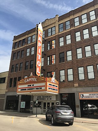
The Aberdeen Micropolitan Statistical Area, as defined by the United States Census Bureau, is an area consisting of two counties in South Dakota, anchored by the city of Aberdeen. As of the 2020 census, the μSA had a population of 42,287.

The Mitchell Micropolitan Statistical Area, as defined by the United States Census Bureau, is an area consisting of two counties in South Dakota, anchored by the city of Mitchell. As of the 2000 census, the μSA had a population of 21,880.

The Pierre Micropolitan Statistical Area, as defined by the United States Census Bureau, is an area consisting of two counties in South Dakota, anchored by the state capital city, Pierre. As of the 2000 census, the μSA had a population of 19,253.

The Kearney Micropolitan Statistical Area, as defined by the United States Census Bureau, is an area consisting of two counties in Nebraska, anchored by the city of Kearney.

The Roanoke Rapids, NC Micropolitan Statistical Area (μSA) as defined by the United States Census Bureau, is an area consisting of two counties in North Carolina, anchored by the city of Roanoke Rapids.

The Charleston–Mattoon, IL Micropolitan Statistical Area, as defined by the United States Census Bureau, is an area consisting of Coles County in central Illinois, anchored by the cities of Charleston and Mattoon.

The Richmond-Berea Micropolitan Statistical Area, as defined by the United States Census Bureau, is an area consisting of two counties in Kentucky, anchored by the cities of Richmond and Berea. As of the 2000 census, the μSA had a population of 87,454.
The Mount Sterling Micropolitan Statistical Area, as defined by the United States Census Bureau, is an area consisting of three counties in Kentucky, anchored by the city of Mount Sterling. As of the 2000 census, the μSA had a population of 40,195.

The Mason City Micropolitan Statistical Area, as defined by the United States Census Bureau, is an area consisting of two counties in north central Iowa, anchored by the city of Mason City.

The Glasgow Micropolitan Statistical Area, as defined by the United States Census Bureau, is an area consisting of two counties in Kentucky, anchored by the city of Glasgow. As of the 2000 census, the μSA had a population of 48,070.

The Russellville Micropolitan Statistical Area (μSA), as defined by the United States Census Bureau, is an area consisting of two counties in the U.S. state of Arkansas, anchored by the city of Russellville.

The Safford Micropolitan Statistical Area, as defined by the United States Census Bureau, is a micropolitan statistical area (μSA) consisting of one county in eastern Arizona, anchored by the city of Safford.
The Wahpeton Micropolitan Statistical Area, as defined by the United States Census Bureau, is an area consisting of two counties – one in southeast North Dakota and one in west central Minnesota, anchored by the city of Wahpeton, North Dakota. As of the 2010 census, the μSA had a population of 22,897.
The Mankato—North Mankato Metropolitan Statistical Area, as defined by the United States Census Bureau, is an area consisting of two counties in south central Minnesota, anchored by the cities of Mankato and North Mankato. It was upgraded from a Micropolitan Statistical Area (μSA) to a Metropolitan Statistical Area (MSA) by the Office of Management and Budget on November 20, 2008. As of the 2020 census, the μSA had a population of 103,566.

The Dickinson Micropolitan Statistical Area, as defined by the United States Census Bureau, is an area consisting of two counties in North Dakota, anchored by the city of Dickinson. As of the 2010 census, the μSA had a population of 24,982.

The Martinsville Micropolitan Statistical Area is a United States Micropolitan Statistical Area (USA) in Virginia, as defined by the Office of Management and Budget (OMB) as of June, 2003. As of the 2000 census, the μSA had a population of 73,346.


