Mount Whitney is the highest mountain in the contiguous United States, with an elevation of 14,505 feet (4,421 m). It is in East–Central California, in the Sierra Nevada, on the boundary between California's Inyo and Tulare counties, and 84.6 miles (136.2 km) west-northwest of North America's lowest topographic point, Badwater Basin in Death Valley National Park, at 282 ft (86 m) below sea level. The mountain's west slope is in Sequoia National Park and the summit is the southern terminus of the John Muir Trail, which runs 211.9 mi (341.0 km) from Happy Isles in Yosemite Valley. The eastern slopes are in Inyo National Forest in Inyo County. Mount Whitney is ranked 18th by topographic isolation.

The gallopheasants are pheasants of the family Phasianidae. The genus comprises 11 species and several subspecies. Several species in this genus are known as firebacks, including crestless and crested firebacks, as well as the Siamese fireback.

Mount Bryce is a mountain at the southwestern corner of the Columbia Icefield, in British Columbia, Canada, near the border with Alberta. It can be seen from the Icefields Parkway.

Mount Jefferson is a mountain located on the Continental Divide between Fremont County of northeastern Idaho and Beaverhead County of southwestern Montana. Mount Jefferson is the highest point of the Centennial Mountains, whose crest runs along the Continental Divide and can be climbed using a class 2 route (scramble) from the access road to neighboring Sawtell Peak.
Michael Mahood is a retired field hockey goalkeeper from Canada, who earned his first international senior cap for the Men's National Team in 1995 against India in Italy. He went on to appear in 196 international matches including two Olympic Games and the 1998 World Cup in Utrecht, Holland. In 1999 he was named to the World XI as part of the FIH 75th Anniversary celebrations in Alexandria, Egypt.

The Clearwater River is the largest tributary of the North Thompson River, joining it at the community of Clearwater, British Columbia. The Clearwater rises from glaciers in the Cariboo Mountains and flows in a mostly southerly direction for 201 km (125 mi) to the North Thompson. Its entire course, except the last 5 km (3 mi), is within Wells Gray Provincial Park. Its confluence with the North Thompson is protected by North Thompson River Provincial Park.
Bleeker: The Rechargeable Dog is a comic strip by Jonathan Mahood about ten-year-old Skip Smalls, his friend Lila, and Bleeker, his electronic dog. The strip is distributed by King Features Syndicate.
Lace was a Canadian country music group who formed in 1998 with the backing of music producer David Foster. Active between 1998 and 2001, the band charted four singles on national country music charts, in addition to releasing a self-titled studio album on 143 Records.

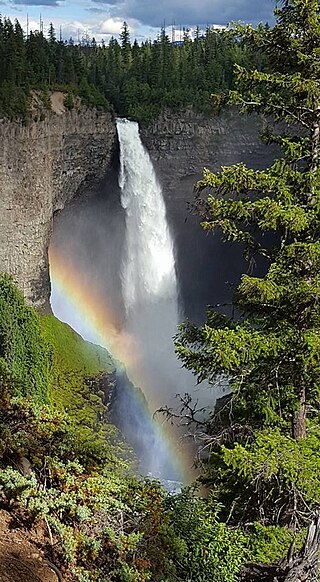
Canim Falls is a 25 metre high waterfall on the Canim River between Canim Lake and Mahood Lake in Wells Gray Provincial Park in the Cariboo region of the Central Interior of British Columbia, Canada. The waterfall has eroded steadily upstream and created a 4 km (2.5 mi) long canyon cut into a lava plateau associated with the Wells Gray-Clearwater volcanic field.

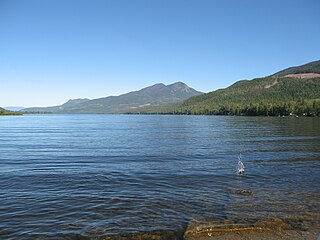
Mahood Lake is a lake in the South Cariboo region of the Interior of British Columbia in Wells Gray Provincial Park. It is drained by the Mahood River, a tributary of the Clearwater River which has cut a deep canyon into Cambrian rocks and Pleistocene glacial moraines. Mahood Lake is fed by the short Canim River, which drains nearby Canim Lake to the west via Canim Falls and Mahood Falls.

The Canim River is a river in the South Cariboo region of the Interior of British Columbia, Canada. It begins at the outlet of Canim Lake and runs 1.8 km (1.1 mi) to Canim Falls, then continues 8 km (5.0 mi) via a canyon cut into a lava plateau to Mahood Lake. A second outlet from Canim Lake, also part of the Canim River, flows over Mahood Falls and joins the Canim Falls branch.
ḵ’els is a mountain located at the head of lekw’emin above the ancestral shíshálh village site of x̱enichen and within the Pacific Ranges of the Coast Mountains of British Columbia, Canada. The mountain is associated with a shíshálh legend about a great flood.

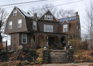
Windsor Hills Historic District is a national historic district in Baltimore, Maryland, United States. It is a cohesive residential suburb defined by rolling topography, winding, picturesque streets, stone garden walls, walks and private alley ways, early-20th century garden apartments, duplexes, and freestanding residences. Structures are predominantly of frame construction with locally quarried stone foundations. Windsor Hills developed over a period from about 1895 through 1929. The dominant styles include Shingle cottages, Dutch Colonial Revival houses, Foursquares, and Craftsman Bungalows.
Mount Lawson is a mountain located in the Kananaskis Range of Alberta. It was named in 1922 by Walter Wilcox and H.G. Bryant after Major W.E. Lawson, an employee with the Geological Survey of Canada who was killed in France during World War I.

Highwood Pass is a mountain pass in Kananaskis Country, Alberta, Canada. It lies west of Mount Rae and Mount Arethusa of the Misty Range, south of Elbow Pass. It lies within the Peter Lougheed Provincial Park on Alberta Highway 40. The Highwood River originates in the pass.
Mount Farnham is British Columbia's 17th highest peak, and 21st most prominent. It was named after Paulding Farnham from New York. It is the highest peak in the Purcells.

Wells Gray Provincial Park is a large wilderness park located in east-central British Columbia, Canada. The park protects most of the southern, and highest, regions of the Cariboo Mountains and covers 5,415 square kilometres. It is British Columbia's fifth largest provincial park, after Tweedsmuir, Tatshenshini, Spatsizi and Northern Rocky Mountains.

Alexander Blount Mahood was a Bluefield, West Virginia-based architect.

Mount Dawson, elevation 3,377 metres (11,079 ft), is a massif in the Selkirk Mountains of British Columbia, Canada, located in Glacier National Park to the southeast of Rogers Pass. It is a double summit, the highest of which is Hasler Peak, the second peak being Feuz Peak, with Hasler Peak's elevation making it the highest summit in Glacier National Park and the second highest in the Selkirks. Mount Dawson is ranked as the 58th highest mountain in British Columbia. The Dawson Glacier is located on its eastern flank.


