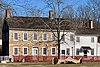
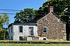
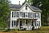
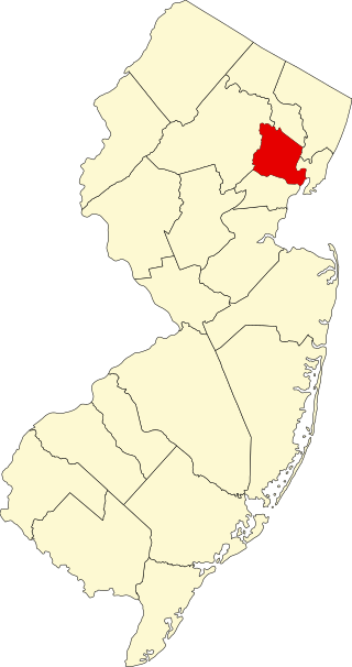
[3] Name on the Register [4] Image Date listed [5] Location City or town Description 1 Amsterdam Historic District Amsterdam Historic District March 17, 1995 (# 95000184 Amsterdam, Church, and Crab Apple Hill roads 40°35′15″N 75°09′34″W / 40.5875°N 75.159444°W / 40.5875; -75.159444 (Amsterdam Historic District ) Amsterdam 2 Annandale Historic District Annandale Historic District September 8, 1994 (# 94001108 Roughly bounded by Maple Avenue, Main Street, Beaver Avenue and East Street 40°38′34″N 74°52′50″W / 40.642778°N 74.880556°W / 40.642778; -74.880556 (Annandale Historic District ) Annandale 3 J. K. Apgar Farmhouse J. K. Apgar Farmhouse November 1, 1979 (# 79001494 CR 512 and Guinea Hollow Rd. 40°42′59″N 74°49′38″W / 40.716389°N 74.827222°W / 40.716389; -74.827222 (J. K. Apgar Farmhouse ) Califon 4 Asbury Historic District Asbury Historic District March 19, 1993 (# 93000132 County Routes 632 and 643, Maple Avenue, Kitchen Road, and School Street, Asbury 40°41′53″N 75°00′50″W / 40.698056°N 75.013889°W / 40.698056; -75.013889 (Asbury Historic District ) Bethlehem Township Primarily in Asbury , Warren County 5 Bartles House Bartles House March 14, 2007 (# 06000763 159 Oldwick Road 40°39′51″N 74°45′06″W / 40.664167°N 74.751667°W / 40.664167; -74.751667 (Bartles House ) Tewksbury Township 6 Bowne Station Road stone arch bridge over tributary of the Alexauken Creek Bowne Station Road stone arch bridge over tributary of the Alexauken Creek April 11, 2024 (# 100010172 Bowne Station Road over tributary of the Alexauken Creek, Bowne 40°25′11″N 74°54′48″W / 40.419778°N 74.913306°W / 40.419778; -74.913306 (Bowne Station Road stone arch bridge over tributary of the Alexauken Creek ) Delaware Township , East Amwell Township Part of the Historic Bridges of Delaware Township, Hunterdon County, New Jersey Multiple Property Submission (MPS) 7 Bray–Hoffman House Bray–Hoffman House January 25, 1973 (# 73001104 39 Sand Hill Road 40°38′13″N 74°51′31″W / 40.637083°N 74.858556°W / 40.637083; -74.858556 (Bray–Hoffman House ) Clinton Township 8 Califon Historic District Califon Historic District October 14, 1976 (# 76001157 Main, Academy, Mill, Bank and First streets; Railroad and Philhower avenues; and River Road 40°43′07″N 74°50′11″W / 40.718611°N 74.836389°W / 40.718611; -74.836389 (Califon Historic District ) Califon 9 Case-Dvoor Farmstead Case-Dvoor Farmstead December 11, 2009 (# 09001074 111 Mine Street 40°30′19″N 74°52′15″W / 40.505278°N 74.870833°W / 40.505278; -74.870833 (Case-Dvoor Farmstead ) Raritan Township Headquarters of the Hunterdon Land Trust 10 Case Farmstead Case Farmstead August 14, 1979 (# 79001496 West of Pattenburg on SR 14 40°38′02″N 75°01′57″W / 40.633889°N 75.0325°W / 40.633889; -75.0325 (Case Farmstead ) Pattenburg 11 Clinton Historic District Clinton Historic District September 28, 1995 (# 95001101 Center, West Main, Main, East Main, Halstead, Water, and Leigh streets 40°38′17″N 74°54′37″W / 40.638056°N 74.910278°W / 40.638056; -74.910278 (Clinton Historic District ) Clinton 12 Clover Hill Historic District Clover Hill Historic District September 29, 1980 (# 80002492 Amwell and Wertsville-Clover Hill Roads 40°29′14″N 74°47′01″W / 40.487222°N 74.783611°W / 40.487222; -74.783611 (Clover Hill Historic District ) Clover Hill Extends into Somerset County 13 Cokesbury Historic District Cokesbury Historic District July 17, 1997 (# 97000802 Cokesbury-Califon Road, CR 639, Water Street, and McCatharn Road 40°41′00″N 74°50′16″W / 40.683333°N 74.837778°W / 40.683333; -74.837778 (Cokesbury Historic District ) Cokesbury 14 Covered Bridge Historic District Covered Bridge Historic District March 5, 1999 (# 99000269 Roughly along CR 604, Pine Hill Road, and Lower Creek Road 40°26′44″N 74°57′50″W / 40.445556°N 74.963889°W / 40.445556; -74.963889 (Covered Bridge Historic District ) Delaware Township Includes Green Sergeant's Covered Bridge 15 Dart's Mill Historic District Dart's Mill Historic District April 29, 1982 (# 82003279 Northeast of Flemington on Rt. 523, Darts Mills 40°32′16″N 74°50′04″W / 40.537778°N 74.834444°W / 40.537778; -74.834444 (Dart's Mill Historic District ) Readington Township 16 Dawlis Mill–Spring Mills Historic District Dawlis Mill–Spring Mills Historic District October 27, 2004 (# 04001192 525 and 530 NJ 31 40°24′56″N 74°51′40″W / 40.415689°N 74.861006°W / 40.415689; -74.861006 (Dawlis Mill–Spring Mills Historic District ) East Amwell Township , West Amwell Township 17 Delaware and Raritan Canal Delaware and Raritan Canal May 11, 1973 (# 73001105 Follows the Delaware River to Trenton, then E to New Brunswick 40°32′40″N 75°02′50″W / 40.544444°N 75.047222°W / 40.544444; -75.047222 (Delaware and Raritan Canal ) Lambertville 18 District No. 98 Schoolhouse District No. 98 Schoolhouse January 12, 2005 (# 04001477 19 S. Main St. 40°24′25″N 74°58′30″W / 40.406944°N 74.975°W / 40.406944; -74.975 (District No. 98 Schoolhouse ) Stockton Borough 19 Dunham's Mill Dunham's Mill April 15, 1982 (# 82003277 7 Lower Center Street 40°38′11″N 74°54′43″W / 40.636389°N 74.911944°W / 40.636389; -74.911944 (Dunham's Mill ) Clinton Home to the Hunterdon Art Museum 20 Everittstown Historic District Everittstown Historic District August 28, 1980 (# 80002496 Intersection of CR 513, CR 519 and Palmyra Road 40°33′58″N 75°01′41″W / 40.566111°N 75.028056°W / 40.566111; -75.028056 (Everittstown Historic District ) Everittstown 21 Charles Eversole House Charles Eversole House February 1, 2006 (# 05001563 509 Cty Rd. 523 40°35′56″N 74°46′39″W / 40.598889°N 74.7775°W / 40.598889; -74.7775 (Charles Eversole House ) Readington Township 22 Fairmount Historic District Fairmount Historic District December 20, 1996 (# 96001470 NJ 517 from the Morris-Hunterdon County line to NJ 512 and NJ 517 from Fox Hill to Wildwood Roads, Fairmount 40°43′08″N 74°46′30″W / 40.718889°N 74.775000°W / 40.718889; -74.775000 (Fairmount Historic District ) Tewksbury Township Extends into Washington Township, Morris County 23 Fink-Type Truss Bridge Fink-Type Truss Bridge December 24, 1974 (# 74001161 West of Allerton off NJ 31 over South Branch of Raritan River 40°36′14″N 74°54′10″W / 40.603889°N 74.902778°W / 40.603889; -74.902778 (Fink-Type Truss Bridge ) Clinton Township Demolished. [6] 24 Flemington Historic District Flemington Historic District September 17, 1980 (# 80002493 Roughly bounded by NJ 12, NJ 31, N. Main, Shields, and Hopewell Aves. 40°30′32″N 74°51′38″W / 40.508889°N 74.860556°W / 40.508889; -74.860556 (Flemington Historic District ) Flemington 25 Frenchtown Historic District Frenchtown Historic District May 19, 1994 (# 94000438 Bounded by 12th Street, Washington Street, the Delaware River and Nishisakawick Creek 40°31′39″N 75°03′45″W / 40.5275°N 75.0625°W / 40.5275; -75.0625 (Frenchtown Historic District ) Frenchtown Includes Uhlerstown–Frenchtown Bridge 26 Frog Hollow Road Bridge over minor tributary of the South Branch Raritan River Frog Hollow Road Bridge over minor tributary of the South Branch Raritan River December 12, 2002 (# 02001509 Frog Hollow Road 40°43′48″N 74°49′06″W / 40.730111°N 74.818333°W / 40.730111; -74.818333 (Frog Hollow Road Bridge over minor tributary of the South Branch Raritan River ) Tewksbury Township Part of the Historic Bridges of Tewksbury Township, Hunterdon County, New Jersey Multiple Property Submission (MPS) 27 Glen Gardner Pony Pratt Truss Bridge Glen Gardner Pony Pratt Truss Bridge September 22, 1977 (# 77000876 School Street over Spruce Run 40°42′05″N 74°56′36″W / 40.70125°N 74.94347°W / 40.70125; -74.94347 (Glen Gardner Pony Pratt Truss Bridge ) Glen Gardner 28 Green Sergeant's Covered Bridge Green Sergeant's Covered Bridge November 19, 1974 (# 74001165 Rosemont-Sergeantsville Road over the Wickecheoke Creek 40°26′39″N 74°57′59″W / 40.444167°N 74.966389°W / 40.444167; -74.966389 (Green Sergeant's Covered Bridge ) Delaware Township 29 Headquarters Historic District Headquarters Historic District July 14, 2011 (# 11000447 Rosemont-Ringoes Road, Zentek Road 40°26′27″N 74°55′25″W / 40.440833°N 74.923611°W / 40.440833; -74.923611 (Headquarters Historic District ) Headquarters Boundary increase February 8, 2016. 30 High Bridge Reformed Church High Bridge Reformed Church November 21, 1980 (# 80002494 Church St. and CR 513 40°40′13″N 74°53′41″W / 40.670278°N 74.894722°W / 40.670278; -74.894722 (High Bridge Reformed Church ) High Bridge 31 Highfields Highfields September 23, 1994 (# 94001096 End of Lindbergh Road 40°25′26″N 74°46′04″W / 40.423889°N 74.767778°W / 40.423889; -74.767778 (Highfields ) East Amwell Township 32 Hollow Brook Road Bridge over tributary of the Lamington River Hollow Brook Road Bridge over tributary of the Lamington River December 12, 2002 (# 02001510 Hollow Brook Road 40°43′02″N 74°44′11″W / 40.717306°N 74.73625°W / 40.717306; -74.73625 (Hollow Brook Road Bridge over tributary of the Lamington River ) Tewksbury Township Part of the Historic Bridges of Tewksbury Township, Hunterdon County, New Jersey MPS 33 Imlaydale Historic District Imlaydale Historic District March 27, 1991 (# 91000306 Imlaydale Road and surrounding land between NJ 31 and the Musconetcong River, Washington and Lebanon Townships 40°42′47″N 74°58′07″W / 40.713056°N 74.968611°W / 40.713056; -74.968611 (Imlaydale Historic District ) Hampton Primarily in Washington Township , Warren County 34 Kalmia Club Kalmia Club April 16, 2012 (# 12000208 39 York Street 40°22′06″N 74°56′40″W / 40.368242°N 74.944507°W / 40.368242; -74.944507 (Kalmia Club ) Lambertville Part of the Clubhouses of New Jersey Women's Clubs Multiple Property Submission 35 Kline Farmhouse Kline Farmhouse July 11, 1984 (# 84002712 NJ 517 40°40′40″N 74°45′06″W / 40.677778°N 74.751667°W / 40.677778; -74.751667 (Kline Farmhouse ) Oldwick 36 Lambertville Historic District Lambertville Historic District June 30, 1983 (# 83001602 NJ 29 and NJ 179 40°21′58″N 74°56′34″W / 40.366111°N 74.942778°W / 40.366111; -74.942778 (Lambertville Historic District ) Lambertville 37 Lambertville House Lambertville House September 6, 1978 (# 78001768 32 Bridge Street 40°21′57″N 74°56′44″W / 40.365833°N 74.945556°W / 40.365833; -74.945556 (Lambertville House ) Lambertville 38 Lansdown Lansdown November 2, 1979 (# 79001497 Northeast of Pittstown on Hamden Road 40°36′22″N 74°54′24″W / 40.606111°N 74.906667°W / 40.606111; -74.906667 (Lansdown ) Lansdowne 39 Lebanon Historic District Lebanon Historic District August 26, 2009 (# 09000652 Main Street, Cherry Street, Brunswick Avenue, Maple Street, High Street 40°38′26″N 74°50′05″W / 40.640556°N 74.834722°W / 40.640556; -74.834722 (Lebanon Historic District ) Lebanon 40 Little York Historic District Little York Historic District August 4, 1988 (# 88001207 CR 614 and Sweet Hollow Road 40°36′47″N 75°04′35″W / 40.613056°N 75.076389°W / 40.613056; -75.076389 (Little York Historic District ) Little York 41 Locktown Baptist Church Locktown Baptist Church February 15, 1974 (# 74001166 323 Locktown-Sergeantsville Road, Locktown 40°29′05″N 74°58′21″W / 40.484722°N 74.9725°W / 40.484722; -74.9725 (Locktown Baptist Church ) Delaware Township 42 James W. Marshall House James W. Marshall House December 18, 1970 (# 70000386 60 Bridge Street 40°21′58″N 74°56′39″W / 40.366111°N 74.944167°W / 40.366111; -74.944167 (James W. Marshall House ) Lambertville 43 David McKinney Mill David McKinney Mill January 8, 1974 (# 74001162 56 Main Street 40°38′10″N 74°54′48″W / 40.636111°N 74.913333°W / 40.636111; -74.913333 (David McKinney Mill ) Clinton Part of the Red Mill Museum Village 44 Mechlin's Corner Tavern Mechlin's Corner Tavern November 1, 1974 (# 74001164 Northwest of Pittstown 40°36′39″N 74°59′17″W / 40.610833°N 74.988056°W / 40.610833; -74.988056 (Mechlin's Corner Tavern ) Mechlings Corner 45 Miller Farmstead Miller Farmstead September 11, 1989 (# 88002118 NJ 57 40°47′09″N 74°53′42″W / 40.785833°N 74.895000°W / 40.785833; -74.895000 (Miller Farmstead ) Lebanon Township Historic farm complex and stone arch bridge. Primarily in Mansfield Township , Warren County . 46 Mount Airy Historic District Mount Airy Historic District November 13, 1989 (# 89001943 Roughly bounded by NJ 179, Rt. 605, Rt. 603, and Rt. 601, Mount Airy 40°23′57″N 74°54′17″W / 40.399167°N 74.904722°W / 40.399167; -74.904722 (Mount Airy Historic District ) West Amwell Township 47 Mount Pleasant Historic District Mount Pleasant Historic District November 16, 1987 (# 87002012 CR 519 and Rick Road 40°34′54″N 75°03′09″W / 40.581667°N 75.0525°W / 40.581667; -75.0525 (Mount Pleasant Historic District ) Mount Pleasant 48 Mount Salem Methodist Episcopal Church Mount Salem Methodist Episcopal Church May 19, 1988 (# 88000592 CR 579 40°36′19″N 74°59′00″W / 40.605278°N 74.983333°W / 40.605278; -74.983333 (Mount Salem Methodist Episcopal Church ) Alexandria Township 49 Mountainville Historic District Mountainville Historic District December 7, 1993 (# 93001360 Main Street, Guinea Hollow, Saw Mill, Rockaway Creek and Philhower Roads 40°41′29″N 74°48′33″W / 40.691389°N 74.809167°W / 40.691389; -74.809167 (Mountainville Historic District ) Mountainville 50 M. C. Mulligan & Sons Quarry M. C. Mulligan & Sons Quarry August 30, 1994 (# 94001010 56 Main Street 40°38′12″N 74°54′49″W / 40.636667°N 74.913611°W / 40.636667; -74.913611 (M. C. Mulligan & Sons Quarry ) Clinton Part of the Red Mill Museum Village 51 Music Hall Music Hall May 7, 1982 (# 82003278 23 W. Main St. 40°38′01″N 74°54′50″W / 40.633611°N 74.913889°W / 40.633611; -74.913889 (Music Hall ) Clinton 52 New Hampton Historic District New Hampton Historic District April 6, 1998 (# 98000257 Roughly along Musconetcong River Road, and Rymon Road 40°43′05″N 74°57′49″W / 40.718056°N 74.963611°W / 40.718056; -74.963611 (New Hampton Historic District ) New Hampton Includes New Hampton Pony Pratt Truss Bridge 53 New Hampton Pony Pratt Truss Bridge New Hampton Pony Pratt Truss Bridge July 26, 1977 (# 77000877 Shoddy Mill Road over the Musconetcong River 40°43′14″N 74°57′49″W / 40.720556°N 74.963611°W / 40.720556; -74.963611 (New Hampton Pony Pratt Truss Bridge ) New Hampton Extends into Warren County, Rymon Road, Washington Township 54 New Market–Linvale–Snydertown Historic District New Market–Linvale–Snydertown Historic District February 12, 1998 (# 98000097 Roughly along NJ 31 , Linvale, Snydertown, and Woodsville Roads, Linvale and Snydertown 40°23′46″N 74°50′05″W / 40.396111°N 74.834722°W / 40.396111; -74.834722 (New Market–Linvale–Snydertown Historic District ) East Amwell Township , West Amwell Township 55 Old Grandin Library Old Grandin Library November 1, 1974 (# 74001163 12 E. Main St. 40°38′13″N 74°54′34″W / 40.636944°N 74.909444°W / 40.636944; -74.909444 (Old Grandin Library ) Clinton 56 Old Stone Presbyterian Church Old Stone Presbyterian Church January 25, 2018 (# 100002053 Corner of Oak Summit Road and County Route 519 40°32′34″N 75°00′20″W / 40.542778°N 75.005556°W / 40.542778; -75.005556 (Old Stone Presbyterian Church ) Kingwood Township Known as the Old Stone Church 57 Oldwick Historic District Oldwick Historic District November 14, 1988 (# 88002153 Roughly along County Route 517, Church, King, James, Joliet and William Streets 40°40′22″N 74°44′57″W / 40.672778°N 74.749167°W / 40.672778; -74.749167 (Oldwick Historic District ) Oldwick 58 Palatine Road Bridge over a minor tributary of the Lamington River Palatine Road Bridge over a minor tributary of the Lamington River December 12, 2002 (# 02001508 Palatine Road, junction with Homestead and Cold Spring Roads 40°41′59″N 74°44′48″W / 40.699667°N 74.746556°W / 40.699667; -74.746556 (Palatine Road Bridge over a minor tributary of the Lamington River ) Tewksbury Township Part of the Historic Bridges of Tewksbury Township, Hunterdon County, New Jersey MPS 59 Peck's Ferry Bridge Peck's Ferry Bridge November 12, 1999 (# 99001313 Locktown-Flemington Road over Plum Brook 40°29′03″N 74°56′36″W / 40.484167°N 74.943472°W / 40.484167; -74.943472 (Peck's Ferry Bridge ) Delaware Township 60 Perryville Tavern Perryville Tavern July 15, 1977 (# 77000874 167 Perryville Road 40°37′59″N 74°58′12″W / 40.633056°N 74.970000°W / 40.633056; -74.970000 (Perryville Tavern ) Perryville 61 Pittstown Historic District Pittstown Historic District October 11, 1990 (# 90001483 Pittstown Road and adjacent portions of Race Street and Quakertown Road, Franklin and Alexandra Townships 40°34′54″N 74°57′33″W / 40.581667°N 74.959167°W / 40.581667; -74.959167 (Pittstown Historic District ) Pittstown 62 Pleasant Valley Historic District Pleasant Valley Historic District June 14, 1991 (# 91000676 Centered on junction of Pleasant Valley Road with Woodens Lane and Hunter Road 40°20′18″N 74°53′44″W / 40.338333°N 74.895556°W / 40.338333; -74.895556 (Pleasant Valley Historic District ) West Amwell Township Extends into Mercer County 63 Potterstown Rural Historic District Potterstown Rural Historic District July 2, 1992 (# 92000806 Along Potterstown and Halls Mill Roads and I-78, Readington and Clinton Townships 40°38′47″N 74°47′05″W / 40.646389°N 74.784722°W / 40.646389; -74.784722 (Potterstown Rural Historic District ) Potterstown 64 Pottersville Village Historic District Pottersville Village Historic District September 18, 1990 (# 90001475 Properties fronting on Black River, Pottersville, McCann Mill and Hacklebarney Roads, Fairmount Road East and High Street 40°42′52″N 74°43′15″W / 40.714444°N 74.720833°W / 40.714444; -74.720833 (Pottersville Village Historic District ) Pottersville Extends into Somerset and Morris Counties 65 Prallsville District Prallsville District June 27, 1979 (# 79001498 NJ 29 40°24′34″N 74°59′09″W / 40.409444°N 74.985833°W / 40.409444; -74.985833 (Prallsville District ) Prallsville 66 Pursley's Ferry Historic District Pursley's Ferry Historic District October 8, 1980 (# 80002495 Old River Road at Church Road 40°34′36″N 75°11′28″W / 40.576667°N 75.191111°W / 40.576667; -75.191111 (Pursley's Ferry Historic District ) Holland Township 67 Quakertown Historic District Quakertown Historic District August 23, 1990 (# 90001242 Roughly bounded by Quakertown, Cherryville Roads, Quaker Lane, and Locust Grove Road 40°33′53″N 74°56′41″W / 40.564722°N 74.944722°W / 40.564722; -74.944722 (Quakertown Historic District ) Quakertown Also known as Quaker Meeting, includes Quaker Meeting House 68 Raritan–Readington South Branch Historic District Raritan–Readington South Branch Historic District January 26, 1990 (# 89002410 River Road from NJ 31 to US 202 40°31′33″N 74°50′21″W / 40.525833°N 74.839167°W / 40.525833; -74.839167 (Raritan–Readington South Branch Historic District ) Raritan Township , Readington Township Includes John Reading Farmstead 69 Raven Rock Historic District Raven Rock Historic District November 10, 2015 (# 15000774 NJ 29 and Quarry Road, Raven Rock 40°24′40″N 75°02′02″W / 40.411111°N 75.033889°W / 40.411111; -75.033889 (Raven Rock Historic District ) Delaware Township 70 Raven Rock Road Bridge Raven Rock Road Bridge October 4, 2016 (# 16000691 Rosemont-Raven Rock Road, Raven Rock 40°24′59″N 75°01′03″W / 40.416254°N 75.017552°W / 40.416254; -75.017552 (Raven Rock Road Bridge ) Delaware Township Part of the Historic Bridges of Delaware Township, Hunterdon County, New Jersey MPS 71 John Reading Farmstead John Reading Farmstead November 21, 1978 (# 78001767 76 River Road 40°31′30″N 74°50′13″W / 40.525000°N 74.836944°W / 40.525000; -74.836944 (John Reading Farmstead ) Raritan Township 72 Readingsburg Historic District Readingsburg Historic District March 3, 2000 (# 00000176 Cokesbury and Stone Mill Roads, CR 639 40°40′54″N 74°52′40″W / 40.681667°N 74.877778°W / 40.681667; -74.877778 (Readingsburg Historic District ) Readingsburg 73 Readington Village Historic District Readington Village Historic District June 24, 1991 (# 91000827 Readington, Hillcrest, Centerville and Brookview Roads 40°34′06″N 74°44′13″W / 40.568333°N 74.736944°W / 40.568333; -74.736944 (Readington Village Historic District ) Readington Includes Readington Reformed Church 74 Reaville Historic District Reaville Historic District May 2, 2002 (# 02000433 Old York, Amwell, Barley Sheaf, Kuhl, and Manners roads 40°28′41″N 74°49′19″W / 40.478056°N 74.821944°W / 40.478056; -74.821944 (Reaville Historic District ) Reaville 75 Riegel Ridge Community Center Riegel Ridge Community Center June 7, 1996 (# 96000656 County Route 519, Riegel Ridge 40°36′34″N 75°07′00″W / 40.609444°N 75.116667°W / 40.609444; -75.116667 (Riegel Ridge Community Center ) Holland Township 76 Ringoes Historic District Ringoes Historic District December 20, 1999 (# 99001544 Old York, John Ringo, Wertsville and Boss Rds., and Larison Ln. 40°25′56″N 74°52′00″W / 40.432222°N 74.866667°W / 40.432222; -74.866667 (Ringoes Historic District ) East Amwell Township 77 Rockhill Agricultural Historic District Rockhill Agricultural Historic District April 5, 1984 (# 84002717 North of Pittstown on SR 513 40°35′59″N 74°57′12″W / 40.599722°N 74.953333°W / 40.599722; -74.953333 (Rockhill Agricultural Historic District ) Union Township 78 Rosemont Rural Agricultural District Rosemont Rural Agricultural District June 18, 2010 (# 10000354 County Routes 519 and 604; Sanford Rd.; Covered Bridge Rd. 40°26′09″N 74°58′35″W / 40.435739°N 74.976306°W / 40.435739; -74.976306 (Rosemont Rural Agricultural District ) Delaware Township 79 Sand Brook Historic District Sand Brook Historic District July 17, 2013 (# 13000497 County Route 523 , Sand Brook-Headquarters & Britton Roads 40°28′07″N 74°55′01″W / 40.468556°N 74.916846°W / 40.468556; -74.916846 (Sand Brook Historic District ) Sand Brook 80 Sergeantsville Historic District Sergeantsville Historic District December 2, 2009 (# 09000972 County Routes 523 and 604, Lambert Rd., Delaware Dr. 40°26′45″N 74°56′39″W / 40.44597°N 74.94405°W / 40.44597; -74.94405 (Sergeantsville Historic District ) Delaware Township 81 St. Thomas Episcopal Church St. Thomas Episcopal Church July 21, 1977 (# 77000878 Southwest of Pittstown on Sky Manor Road 40°33′38″N 74°59′22″W / 40.560556°N 74.989444°W / 40.560556; -74.989444 (St. Thomas Episcopal Church ) Alexandria Township 82 Stanton Historic Rural District Stanton Historic Rural District August 10, 1990 (# 90001225 Jct. of Stanton and Mountain Rds., between Round and Cushetunk Mtns., Stanton 40°34′34″N 74°50′03″W / 40.5761°N 74.8342°W / 40.5761; -74.8342 (Stanton Historic Rural District ) Readington Township 83 Stone Sign Post Road Bridge over Plum Brook Stone Sign Post Road Bridge over Plum Brook October 4, 2016 (# 16000692 Stone Sign Post Road 40°29′26″N 74°56′19″W / 40.4905°N 74.9387°W / 40.4905; -74.9387 (Stone Sign Post Road Bridge over Plum Brook ) Delaware Township Part of the Historic Bridges of Delaware Township, Hunterdon County, New Jersey MPS 84 Strimple's Mill Road Bridge over Lockatong Creek Strimple's Mill Road Bridge over Lockatong Creek October 4, 2016 (# 16000693 Strimple's Mill Road 40°26′14″N 75°00′42″W / 40.4371°N 75.0118°W / 40.4371; -75.0118 (Strimple's Mill Road Bridge over Lockatong Creek ) Delaware Township Part of the Historic Bridges of Delaware Township, Hunterdon County, New Jersey MPS 85 Taylor's Mill Historic District Taylor's Mill Historic District June 11, 1992 (# 92000636 Taylor's Mill Road and Rockaway Road 40°39′48″N 74°46′06″W / 40.6633°N 74.7683°W / 40.6633; -74.7683 (Taylor's Mill Historic District ) Readington Township 86 Thatcher House Thatcher House December 4, 2020 (# 100005851 255 Ridge Road 40°32′16″N 75°01′24″W / 40.5378°N 75.0233°W / 40.5378; -75.0233 (Thatcher House ) Kingwood Township 87 Turner–Chew–Carhart Farm Turner–Chew–Carhart Farm August 11, 1977 (# 77000875 Northwest of Clinton on Van Syckles Road 40°39′12″N 74°57′27″W / 40.6533°N 74.9575°W / 40.6533; -74.9575 (Turner–Chew–Carhart Farm ) Union Township 88 John Van Syckle House John Van Syckle House April 2, 2012 (# 10000814 195 Rummel Rd. 40°35′52″N 75°04′30″W / 40.5978°N 75.0751°W / 40.5978; -75.0751 (John Van Syckle House ) Holland Township 89 Van Syckel Corner District Van Syckel Corner District November 8, 1979 (# 79001495 Van Syckels Corner and Norton Roads 40°38′58″N 74°58′38″W / 40.6494°N 74.9772°W / 40.6494; -74.9772 (Van Syckel Corner District ) Union Township 90 Christoffel Vought Farmstead Christoffel Vought Farmstead January 16, 2008 (# 07001403 East of Grey Rock Road, 600 feet (180 m) north of the junction with NJ 31. 40°38′36″N 74°53′54″W / 40.6433°N 74.8983°W / 40.6433; -74.8983 (Christoffel Vought Farmstead ) Annandale 91 Wertsville Historic District Wertsville Historic District October 5, 2000 (# 00001150 Wertsville and Lindbergh Roads 40°26′54″N 74°47′46″W / 40.4483°N 74.7961°W / 40.4483; -74.7961 (Wertsville Historic District ) East Amwell Township 92 Whitehouse Station Whitehouse Station June 22, 1984 (# 84002726 Main Street, Whitehouse Station 40°36′55″N 74°46′16″W / 40.6153°N 74.7711°W / 40.6153; -74.7711 (Whitehouse Station ) Readington Township 93 Whitehouse–Mechanicsville Historic District Whitehouse–Mechanicsville Historic District March 17, 2015 (# 15000093 Old New Jersey Route 28 , Mill, Lamington and School Roads 40°37′17″N 74°45′34″W / 40.6214°N 74.7594°W / 40.6214; -74.7594 (Whitehouse–Mechanicsville Historic District ) Readington Township