National Register of Historic Places listings in Oconto County, Wisconsin
Last updated
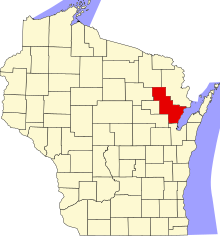
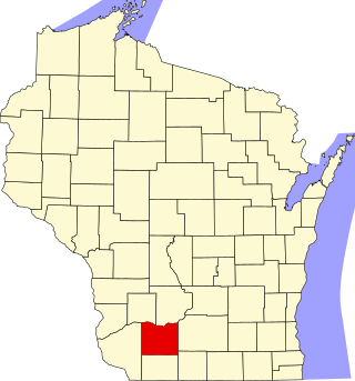
Location of Oconto County in Wisconsin
This is a list of the National Register of Historic Places listings in Oconto County, Wisconsin. It is intended to provide a comprehensive listing of entries in the National Register of Historic Places that are located in Oconto County, Wisconsin. The locations of National Register properties for which the latitude and longitude coordinates are included below may be seen in a map.[1]
Wisconsin’s first water-powered sawmill and lumbering operation operated from 1827 until the 1860s. The only surviving structure is the dam levy on the Pensaukee River.[7]
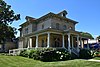
Brick home built in 1868 in Italianate style by Cyrus and Kitty Hart. Remodelled around 1881 to Queen Anne by George Beyer,[8] German immigrant, bookkeeper, and businessman. Now a museum.
The WPA built this concrete dam in 1937 to create a recreational flowage on the Oconto River, and to provide jobs. It is on the site of an earlier log dam.[10]
Neoclassical bank built in 1904 and lasting until 1932. Since then the building has housed a grocery store, a clothes store, a glove factory and now a dentist.[11]
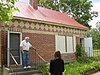
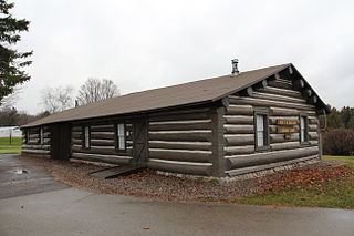
Log building built in 1880, with cookhouse and bunkhouse - possibly the oldest logging camp in the U.S. standing on its original site. Now a museum.[14][15]
Possibly the oldest remaining home in Oconto, built in 1851 in Greek Revival style. Jones and his sons built the first stream sawmill on the Oconto River.[17]
The 1866 Greek Revival Guild Hall (a.k.a. 1866-1867 Methodist Church) now houses a local theater troupe. The 1866 (or 1871?) vicarage is now styled Queen Anne. The Neo-Gothic church was demolished in 1998.[6][25][26][27]
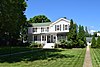
Italianate house built in 1868 by lumberman William Brunquest. Later the home of Wisconsin's 19th governor, where he died. Also called the Tellez house.[6][30]
This is a list of the National Register of Historic Places listings in Sauk County, Wisconsin. It is intended to provide a comprehensive listing of entries in the National Register of Historic Places that are located in Sauk County, Wisconsin. The locations of National Register properties for which the latitude and longitude coordinates are included below may be seen in a map.
This is a list of the National Register of Historic Places listings in Brown County, Wisconsin. It is intended to provide a comprehensive listing of entries in the National Register of Historic Places that are located in Brown County, Wisconsin. The locations of National Register properties for which the latitude and longitude coordinates are included below may be seen in a map.
This is a list of the National Register of Historic Places listings in Columbia County, Wisconsin.
This is a list of the National Register of Historic Places listings in Door County, Wisconsin. It is intended to provide a comprehensive listing of entries in the National Register of Historic Places that are located in Door County, Wisconsin. The locations of National Register properties for which the latitude and longitude coordinates are included below may be seen in a map.
This is a list of the National Register of Historic Places listings in Eau Claire County, Wisconsin. It is intended to provide a comprehensive listing of entries in the National Register of Historic Places that are located in Eau Claire County, Wisconsin. The locations of National Register properties for which the latitude and longitude coordinates are included below may be seen in a map.
This is a list of the National Register of Historic Places listings in Iowa County, Wisconsin. It is intended to provide a comprehensive listing of entries in the National Register of Historic Places that are located in Iowa County, Wisconsin. The locations of National Register properties for which the latitude and longitude coordinates are included below may be seen in a map.
This is a list of the National Register of Historic Places listings in Walworth County, Wisconsin. It is intended to provide a comprehensive listing of entries in the National Register of Historic Places that are located in Walworth County, Wisconsin. The locations of National Register properties for which the latitude and longitude coordinates are included below may be seen in a map.
This is a list of the National Register of Historic Places listings in Crawford County, Wisconsin. It is intended to provide a comprehensive listing of entries in the National Register of Historic Places that are located in Crawford County, Wisconsin. The locations of National Register properties for which the latitude and longitude coordinates are included below may be seen in a map.
This is a list of the National Register of Historic Places listings in Ashland County, Wisconsin. It is intended to provide a comprehensive listing of entries in the National Register of Historic Places that are located in Ashland County, Wisconsin. The locations of National Register properties for which the latitude and longitude coordinates are included below may be seen in a map.
This is a list of the National Register of Historic Places listings in Marinette County, Wisconsin. It is intended to provide a comprehensive listing of entries in the National Register of Historic Places that are located in Marinette County, Wisconsin. The locations of National Register properties for which the latitude and longitude coordinates are included below may be seen in a map.
This is a list of the National Register of Historic Places listings in Portage County, Wisconsin. It is intended to provide a comprehensive listing of entries in the National Register of Historic Places that are located in Portage County, Wisconsin. The locations of National Register properties for which the latitude and longitude coordinates are included below may be seen in a map.
This is a list of the National Register of Historic Places listings in Barron County, Wisconsin. It is intended to provide a comprehensive listing of entries in the National Register of Historic Places that are located in Barron County, Wisconsin. The locations of National Register properties for which the latitude and longitude coordinates are included below may be seen in a map.
This is a list of the National Register of Historic Places listings in Chippewa County, Wisconsin. It is intended to provide a comprehensive listing of entries in the National Register of Historic Places that are located in Chippewa County, Wisconsin. The locations of National Register properties for which the latitude and longitude coordinates are included below may be seen in a map.
This is a list of the National Register of Historic Places listings in Buffalo County, Wisconsin. It is intended to provide a comprehensive listing of entries in the National Register of Historic Places that are located in Buffalo County, Wisconsin. The locations of National Register properties for which the latitude and longitude coordinates are included below may be seen in a map.
This is a list of the National Register of Historic Places listings in Polk County, Wisconsin. It is intended to provide a comprehensive listing of entries in the National Register of Historic Places that are located in Polk County, Wisconsin. The locations of National Register properties for which the latitude and longitude coordinates are included below may be seen in a map.
This is a list of the National Register of Historic Places listings in Price County, Wisconsin. It is intended to provide a comprehensive listing of entries in the National Register of Historic Places that are located in Price County, Wisconsin. The locations of National Register properties for which the latitude and longitude coordinates are included below may be seen in a map.
This is a list of the National Register of Historic Places listings in Wood County, Wisconsin. It is intended to provide a comprehensive listing of entries in the National Register of Historic Places that are located in Wood County, Wisconsin. The locations of National Register properties for which the latitude and longitude coordinates are included below may be seen in a map.
The Holt and Balcom Logging Camp No. 1 in Lakewood, Wisconsin was built around 1880 in what was then timber along McCaslin Brook. It is probably the oldest lumber camp in Wisconsin still standing in its original location, and was added to the National Register of Historic Places in 1978.
This is a list of the National Register of Historic Places listings in Forest County, Wisconsin. It is intended to provide a comprehensive listing of entries in the National Register of Historic Places that are located in Forest County, Wisconsin. The locations of National Register properties for which the latitude and longitude coordinates are included below may be seen in a map.
Wade House Historical Site, also called Old Wade House, is a 240-acre (97 ha) open-air museum in Greenbush, Wisconsin. A Wisconsin historic site, the site is operated by the Wisconsin Historical Society.
References
↑ The latitude and longitude information provided is primarily from the National Register Information System, and has been found to be fairly accurate for about 99% of listings. For 1%, the location info may be way off. We seek to correct the coordinate information wherever it is found to be erroneous. Please leave a note in the Discussion page for this article if you believe any specific location is incorrect.
↑ Numbers represent an alphabetical ordering by significant words. Various colorings, defined here, differentiate National Historic Landmarks and historic districts from other NRHP buildings, structures, sites or objects.
↑ The eight-digit number below each date is the number assigned to each location in the National Register Information System database, which can be viewed by clicking the number.
↑ Miller, Elizabeth; Kim Potaracke. "Mountain Fire Lookout Tower"(PDF). National Register of Historic Places - Registration Form. U.S. Department of the Interior - National Park Service. Retrieved 2013-11-03.
This page is based on this Wikipedia article Text is available under the CC BY-SA 4.0 license; additional terms may apply. Images, videos and audio are available under their respective licenses.