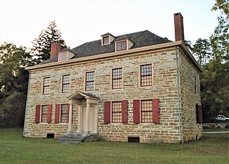
Fort Johnson | |
(2020) | |
Location | 2 Mergner Rd., Fort Johnson, NY |
---|---|
Nearest city | Amsterdam |
Coordinates | 42°57′26″N74°14′30″W / 42.95722°N 74.24167°W Coordinates: 42°57′26″N74°14′30″W / 42.95722°N 74.24167°W |
Area | 1 acre (0.40 ha) |
Built | ca. 1749 |
Architectural style | Georgian |
NRHP reference No. | 72000858 |
Significant dates | |
Added to NRHP | November 28, 1972 [1] |
Designated NHL | November 28, 1972 [2] |
Old Fort Johnson is a historic house museum and historic site at 2 Mergner Road (junction of New York State Routes 5 and 67) in Fort Johnson, New York. It is the site of Fort Johnson, a two-story stone house originally enclosed in fortifications built by Sir William Johnson about 1749. The fort served as Johnson's home, business office and trading center until 1763 when he moved to Johnson Hall in what is now Johnstown, New York. [3] Sir William's son Sir John Johnson owned the house from 1763 until 1776, when it was confiscated by the local Committee of Safety. The house remains and is owned and operated as a museum by the Montgomery County Historical Society. It was designated a National Historic Landmark in 1972. [2] [4] [5]
Old Fort Johnson is located at the center of the village of Fort Johnson, on the north side of NY Route 5 overlooking the Mohawk River just west of NY Route 67. The property, about 1 acre (0.40 ha) in size, is fringed on the front and east side by a low stone retaining wall. The house is a 2-1/2 story structure, built out of limestone and topped by a hip roof. Brick chimneys are located in the side walls, and the front face of the roof is pierced by three gabled dormers. The front facade is five bays wide, with a center entrance sheltered by a gabled portico supported by Doric columns. The interior follows a central hall plan, with a parlor and study on the left, and a large dining room and serving chamber on the right; the kitchen is located in the basement. [4]
William Johnson came to what is now Upstate New York in 1738, establishing a sawmill nearby and engaging in trade with the local Iroquois. Johnson built this house about 1749, after King George's War ended. The house was surrounded by a wooden palisade during the French and Indian War. Johnson was influential in relations between the colonial government and the local Mohawk people, and was named the crown Superintendent of Indian Affairs in 1756. He moved further west, establishing Johnson Hall as his seat in 1763. This house became the home of his son John, who was a leading Loyalist during the American Revolutionary War. Both Fort Johnson and Johnson Hall were seized by the state and auctioned off due to the Johnson's opposition to independence. After passing through many owners, Fort Johnson was purchased in the 1920s by John Watts DePeyster and given to the Montgomery County Historical Society, which now operates it as a museum. [4]
Danube is a town in Herkimer County, New York, United States. The population was 1,039 at the 2010 census. Early Palatine German immigrants in the eighteenth century named the town after the Danube River in Europe.
Fort Johnson is a village in Montgomery County, New York, United States located on the north side of the Mohawk River. The population was 490 at the 2010 census.
Sir William Johnson, 1st Baronet, was an Irish official of the British Empire. As a young man, Johnson moved to the Province of New York to manage an estate purchased by his uncle, Admiral Peter Warren, which was located amidst the Mohawk, one of the Six Nations of the Iroquois League. Johnson learned the Mohawk language and Iroquois customs, and was appointed the British agent to the Iroquois. Because of his success, he was appointed in 1756 as British Superintendent of Indian Affairs for the northern colonies. Throughout his career as a British official among the Iroquois, Johnson combined personal business with official diplomacy, acquiring tens of thousands of acres of Native land and becoming very wealthy.
Johnstown is a town located in Fulton County, New York, United States. As of the 2010 census, the town had a population of 7,098. The name of the town is from landowner William Johnson. The town of Johnstown is located on the southern border of the county. It borders on three sides the city of Johnstown and the city of Gloversville.
Johnstown is a city in and the county seat of Fulton County in the U.S. state of New York. The city was named after its founder, Sir William Johnson, Superintendent of Indian Affairs in the Province of New York and a major general during the Seven Years' War in North America. It is located approximately 45 miles (72 km) northwest of Albany, about one-third of the way between Albany and the Finger Lakes region to the west, in the Mohawk Valley region, within the foothills of the Adirondack Mountains.
Amsterdam is a town in Montgomery County, New York, United States. The population was 5,566 at the 2010 census. The town is named after Amsterdam, the capital of the Netherlands.
Amsterdam is a city in Montgomery County, New York, United States. As of the 2010 census, the city had a population of 18,620. The city is named after Amsterdam in the Netherlands.
St. Johnsville is a town in Montgomery County, New York, United States. The population was 2,631 at the 2010 census. Accounts vary as to the naming of St. Johnsville, but most of them state that the town and its village are named after an early surveyor and commissioner, Alexander St. John. Still others credit the naming of St. Johnsville to a former name for the area, St. John's Church.
Peter Gansevoort was a Colonel in the Continental Army during the American Revolutionary War. He is best known for leading the resistance to Barry St. Leger's Siege of Fort Stanwix in 1777. Gansevoort was also the maternal grandfather of Moby-Dick author Herman Melville.
The Battle of Oriskany was one of the bloodiest battles in the American Revolutionary War and a significant engagement of the Saratoga campaign. On August 6, 1777, a party of Loyalists and several hundred Indigenous allies across several nations ambushed an American military party that was marching to relieve the siege of Fort Stanwix. This was one of the few battles in which the majority of the participants were Americans; Patriots and allied Oneidas fought against Loyalists and allied Iroquois in the absence of British regular soldiers. There was also a detachment of Hessians in the British force, as well as Western Indians including members of the Mississauga people.
Molly Brant, also known as Mary Brant, Konwatsi'tsiaienni, and Degonwadonti, was influential in New York and Canada in the era of the American Revolution. Living in the Province of New York, she was the consort of Sir William Johnson, the British Superintendent of Indian Affairs, with whom she had eight children. Joseph Brant, who became a Mohawk leader and war chief, was her younger brother.
Located in the village of Schoharie, Schoharie County New York, the Old Stone Fort was originally built as a Reformed Dutch Church in 1772. With the coming of the American Revolutionary War, the church was enclosed by a log stockade in 1777.
Fort Klock, a fortified stone homestead in the Mohawk River Valley of Upstate New York, was built c.1750 by Johannes Klock, and is a good example of a mid-18th century fortified home and trading post, seeing use during the French and Indian War and the American Revolutionary War The fort is located at 7203 Route 5 roughly two miles (3 km) east of the Village of St. Johnsville, New York. Fort Klock is part of a 30-acre (12 ha) complex that includes the historic homestead, a renovated Colonial Dutch Barn, blacksmith shop, and 19th-century schoolhouse. The site is maintained by Fort Klock Historic Restoration and is open seasonally as a living museum. The fort was declared a National Historic Landmark in 1972.
Mohawk Upper Castle Historic District is a historic district in Herkimer County, New York that was declared a National Historic Landmark in 1993. Located south of the Mohawk River, it includes the Indian Castle Church, built in 1769 by Sir William Johnson, British Superintendent of Indian Affairs, as a missionary church for the Mohawk in the western part of their territory; the Brant Family Barn, a rare surviving example of Dutch colonial barns in the Mohawk Valley; as well as important archaeological site areas revealing life in Nowadaga, as the western part of the Mohawk village of Canajoharie was known. The fortified village was called the Upper Castle by European colonists.
Schoharie Crossing State Historic Site, also known as Erie Canal National Historic Landmark, is a historic district that includes the ruins of the Erie Canal aqueduct over Schoharie Creek, and a 3.5-mile (5.6 km) long part of the Erie Canal, in the towns of Glen and Florida within Montgomery County, New York. It was the first part of the old canal to be designated a National Historic Landmark, prior to the designation of the entire New York State Barge Canal as a NHL in 2017.
Johnson Hall State Historic Site was the home of Sir William Johnson (1715–1774) an Irish pioneer who became the influential British Superintendent of Indian Affairs in the Province of New York, known for his strong relationship especially with the Mohawk and other Iroquois League nations.
James Addison Johnson was an American architect known for his design of various architectural landmarks in Buffalo, New York, and his use of decorative work that many consider a foreshadowing of art deco design.
Indian Castle Church is a historic mission church at Indian Castle in Herkimer County, New York. The church is located on NYS Route 5S near present-day Danube. It is a one-story, rectangular wood frame structure, clad in clapboard with a gable roof and steeple. To the rear of the church is a burial ground containing the remains of both Mohawks and Europeans.
Tryon County was a county in the colonial Province of New York in the British American colonies. It was created from Albany County on March 24, 1772, and was named for William Tryon, the last provincial governor of New York. The county's boundaries extended much further than any current county. Its eastern boundary with the also-new Charlotte County ran "from the Mohawk River to the Canada line, at a point near the old village of St. Regis and passing south to the Mohawk between Schenectady and Albany." It extended north to the St. Lawrence River; its western boundary was the Treaty of Fort Stanwix's Line of Property, following the Unadilla River, Oneida Lake, Onondaga River and Oswego River to Lake Ontario, as the Iroquois Confederacy still controlled locations further west in the Indian Reserve. Tryon County's seat was Johnstown, which is today the county seat of Fulton County. The Tryon County Courthouse, built in 1772–1773, was listed on the National Register of Historic Places in 1972. The Tryon County Jail, also built in 1772–1773, was listed on the National Register of Historic Places in 1981.
Notes
Bibliography
Wikimedia Commons has media related to Old Fort Johnson . |