A black panther is the melanistic colour variant of the leopard and the jaguar. Black panthers of both species have excess black pigments, but their typical rosettes are also present. They have been documented mostly in tropical forests, with black leopards in Africa and Asia, and black jaguars in South America. Melanism is caused by a recessive allele in the leopard, and by a dominant allele in the jaguar.
Wakanda, officially the Kingdom of Wakanda, is a fictional country appearing in American comic books published by Marvel Comics. Created by Stan Lee and Jack Kirby, the country first appeared in Fantastic Four #52. Wakanda is located in sub-Saharan Africa and has been depicted as being in East Africa. It is home to the superhero Black Panther.
The Western Lakes and Mountains region spans most of Maine's western border with New Hampshire. A small part of the scenic White Mountain National Forest is located in this area. The region consists of Oxford County, Androscoggin County, Franklin County, as well as northern York and interior Cumberland counties. The largest cities in the region are Lewiston and Auburn. Notable towns include Bethel, Bridgton, Oxford, Rangeley, and Rumford. Many of the state's highest peaks are located in the region, although the highest, Mount Katahdin, is not.

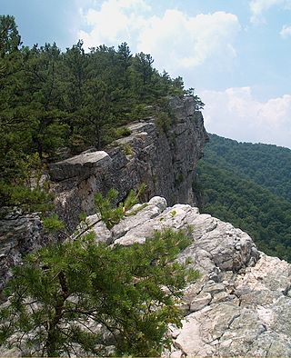
North Fork Mountain is a quartzite-capped mountain ridge in the Ridge and Valley physiographic province of the Allegheny Mountains, also known as the High Alleghenies or Potomac Highlands, of eastern West Virginia. Kile Knob, at 4,588 feet, is the mountain's highest point, and Panther Knob and Pike Knob are nearly as high.

Panther Mountain is one of the Catskill High Peaks, located in the Town of Shandaken in Ulster County, New York. At approximately 3,720 feet (1,130 m) in elevation, it is the 18th highest in the range. A combination of factors has led some geologists to believe the mountain is on the site of an ancient meteorite impact crater.
The West Canada Lake Wilderness Area is an Adirondack Park Forest Preserve management unit in the State of New York, USA.

Panther Falls are a series of waterfalls in Banff National Park, Alberta, Canada. It is developed on Nigel Creek and its waters originate in Nigel Pass, between the slopes of Cirrus Mountain and Nigel Peak in the Parker Ridge of the Canadian Rockies.
Couchsachraga Peak is a mountain located in Essex County, New York. "Couchsachraga" is based on an Algonquin or Huron name for the area, meaning "dismal wilderness". The mountain is part of the Santanoni Range of the Adirondacks. Couchsachraga Peak is flanked to the east by Panther Peak. There is no marked trail to the summit, which, being fully forested, has no views.

Panther Peak is a mountain in the Santanoni Range of the Adirondacks in the U.S. state of New York. It is the 18th-highest of the Adirondack High Peaks, with an elevation of 4,714 feet (1,437 m). It is located in the town of Keene in Essex County, inside Adirondack Park. The mountain is named after the panthers which were once native to the region. The name "Panther Peak" was in use by 1840, but originally referred to a different mountain now known as Mount Henderson. By 1904, the name had been transferred to the present Panther Peak. The earliest recorded ascent was also made in 1904 by surveyor Daniel Lynch. The mountain is flanked by two other High Peaks in the Santanoni Range, Couchsachraga Peak and Santanoni Peak.
Panther Creek Falls Trail is an interior hiking trail in Georgia's Cohutta Mountains, in Fannin County, northwest of Ellijay, at the southern end of the Smoky Mountains. The trail falls within the 35,000-acre Cohutta Wilderness, part of the Wilderness's 87 mile (140 km) trail system. As an interior trail, Panther Creek Falls cannot be accessed by road, but only via other hiking trails. Eastern access is via the East Cowpen Trail, and its western access via the Conasauga River Trail. The trail starts at the confluence of Panther Creek and the Conasauga River.
The Tenny River is a 1.0-mile-long (1.6 km) navigable stream connecting Crescent Lake with Panther Pond in the town of Raymond in the U.S. state of Maine. The river drops just one foot in elevation over its course, from 278 feet (85 m) above sea level at Crescent Lake to 277 feet (84 m) at Panther Pond, the outlet of which then drops another 10 feet (3.0 m) to Sebago Lake. The Tenny River is part of the Presumpscot River watershed, flowing to Casco Bay, an arm of the Atlantic Ocean.
Panther is an unincorporated community in McDowell County, West Virginia, United States. Panther is located along the Tug Fork, 4.5 miles (7.2 km) west-northwest of Iaeger. Panther has a post office with ZIP code 24872.

Bannock Peak is a 10,329-foot (3,148-metre) mountain summit in the southern section of the Gallatin Range in Yellowstone National Park, in the U.S. state of Wyoming. The peak ranks as the sixth-highest peak in the Gallatin Range. Precipitation runoff from the mountain drains west into headwaters of the Gallatin River and east into Panther Creek which is a tributary of the Gardner River. Topographic relief is significant as the summit rises nearly 2,000 feet above Panther Creek in one mile (1.6 km). This mountain's toponym was officially adopted in 1897 by the United States Board on Geographic Names.

The Ouarsenis or Ouanchariss is a mountain range and inhabited region in northwestern Algeria.

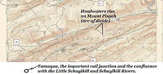
Panther Creek is a 2 branch creek running through parts of Schuylkill and Carbon County. The west-draining branch tributary of the Little Schuylkill River's drainage basin and rises in the vicinity of the east side of Lansford and Coaldale in the plateau-like nearly flat terrain of the complex three-way saddle between Mount Pisgah. It continues to flow through the towns of Coaldale into Tamaqua where it meets the Little Schuylkill River. The Panther Creek branch to its east, Nesquehoning Ridge to the north and Pisgah Ridge to the south, both ridgelines flanking its entire course as it makes its way east-northeast to west-southwest. Starting in Nesquehoning it eventually runs into the Lehigh River just outside of Jim Thorpe.

Pisgah Mountain, or Pisgah Ridge on older USGS maps, is a ridgeline running 12.5 miles (20.1 km) from Tamaqua to Jim Thorpe, Pennsylvania from the Little Schuylkill River water gap to the Lehigh River water gap.

Nesquehoning Mountain or Nesquehoning Ridge is a 15–17-mile-long (24–27 km) coal bearing ridge dividing the waters of Lehigh Valley to the north from the Schuylkill River valley and the several near parallel ridgelines of the Ridge-and-Valley Appalachians barrier range all local members of which run generally WSW-ENE in the greater overall area.
Panther Mountain is a mountain located in Central New York of New York near Fly Creek, New York and Schuyler Lake, New York. The east side of Panther Mountain drains into Fly Creek and the west side drains into Oaks Creek and Canadarago Lake.
The Cliffs Valley is a resort community and census-designated place (CDP) in Greenville County, South Carolina, United States. It was first listed as a CDP prior to the 2020 census with a population of 736.

Operation "Breza 94" was the official codename for the military offensive conducted by the 1st Krajina Corps of the VRS in September 1994 in Bosanska Krajina. The objective of the offensive was the breaking of the 5th Corps and the conquest of Bosanska Krajina. The offensive ended in VRS defeat with the ARBiH capturing 20 square kilometers previously held by Serbs.


