Portuguese nautical science

Last updated

Portuguese nautical science evolved from the successive expeditions and experience of the Portuguese pilots. It led to a fairly rapid evolution, creating an elite of astronomers, navigators, mathematicians and cartographers. Among them stood Pedro Nunes with studies on how to determine latitude by the stars, and João de Castro, who made important observations of magnetic declination over the entire route around Africa.

Contents

Ships

Portuguese "Armada" fleet in 1507, Lisuarte de Abreu Armada portugaise.jpg
Portuguese "Armada" fleet in 1507, Lisuarte de Abreu

Until the 15th century, the Portuguese were limited to cabotage navigation using barques and barinels (ancient cargo vessels used in the Mediterranean). These boats were small and fragile, with only one mast with a fixed quadrangular sail and did not have the capabilities to overcome the navigational difficulties associated with southward oceanic exploration, as the strong winds, shoals and strong ocean currents easily overwhelmed their abilities. They are associated with the earliest discoveries, such as the Madeira Islands, the Azores, the Canaries, and to the early exploration of the northwest African coast as far south as Arguim in the current Mauritania.

The ship that truly launched the first phase of the Portuguese discoveries along the African coast was the caravel, a development based on existing fishing boats. They were agile and easier to navigate, with a tonnage of 50 to 160 tons and 1 to 3 masts, with lateen triangular sails allowing luffing. The caravel's limited capacity for cargo and crew were its main drawbacks, but these did not hinder its success. Among the famous caravels are Berrio, which was the first ship of Vasco da Gama's first armada to reach Portugal after the voyage, and Anunciação (Nossa Senhora da Anunciação), which sailed with Cabral in 1500.

With the start of long oceanic sailing, larger ships were also developed. "Nau" was the Portuguese archaic synonym for any large ship, primarily merchant ships. Due to the piracy that plagued the coasts, they began to be used in the navy and were provided with cannon ports, which led to the classification of "naus" according to the power of the ship's artillery. They were also adapted to the increasing maritime trade: from 200 tons capacity in the 15th century to 500 tons later, they become impressive in the 16th century, having usually two decks, fighting castles fore and aft, and two to four masts with overlapping sails. In voyages to India in the sixteenth century, carracks were also used. These were large merchant ships with a high edge (freeboard) and three masts with square sails, which often reached 2000 tons.

Celestial navigation

Ephemeris by Abraham Zacuto in Almanach Perpetuum, 1496 AlmanachPerpetuum.jpg
Ephemeris by Abraham Zacuto in Almanach Perpetuum, 1496

In the thirteenth century celestial navigation was already known, guided by the sun position. For celestial navigation the Portuguese, like other Europeans, used Arab navigation tools, like the astrolabe and quadrant, which they made easier and simpler. They also created the cross-staff, or cane of Jacob, for measuring at sea the height of the sun and other stars. The Southern Cross become a reference upon arrival in the Southern hemisphere by João de Santarém and Pedro Escobar in 1471, starting the use of this constellation in celestial navigation. But the results varied throughout the year, which required corrections.

To this the Portuguese used the astronomical tables (Ephemeris), precious tools for oceanic navigation, which experienced a remarkable diffusion in the fifteenth century. These tables revolutionized navigation, allowing mariners to calculate their latitude. Vasco da Gama and Pedro Álvares Cabral used the tables of the Almanach Perpetuum by astronomer Abraham Zacuto, which were published in Leiria in 1496, along with his improved astrolabe.

Sailing techniques

Oceanic gyres.png
North Atlantic
gyre
North Atlantic
gyre
North Atlantic
gyre
Indian
Ocean
gyre
North
Pacific
gyre
South
Pacific
gyre
South Atlantic
     gyre
Oceanic gyres.png
World map of the five major ocean gyres

Besides coastal exploration, Portuguese also made trips off in the ocean to gather meteorological and oceanographic information (in these trips were discovered the archipelagos of Madeira and the Azores, and the Sargasso Sea). The knowledge of wind patterns and currents – the trade winds and the oceanic gyres in the Atlantic, and the determination of latitude led to the discovery of the best ocean route back from Africa: crossing the Central Atlantic to the latitude of the Azores, using the permanent favorable winds and currents that spin clockwise in the Northern Hemisphere because of atmospheric circulation and the Coriolis effect, facilitating the way to Lisbon and thus enabling the Portuguese to venture increasingly farther from shore, the maneuver that became known as "Volta do mar". In 1565, application of this principle in the Pacific Ocean led to the Spanish discovery of the Manila Galleon trade route between Mexico and the Philippines.

Cartography

Pre-mercator navigation chart of the Coast of Africa (1571), by Fernao Vaz Dourado (Torre do Tombo, Lisbon) Fernao Vaz Dourado 1571-1.jpg
Pre-mercator navigation chart of the Coast of Africa (1571), by Fernão Vaz Dourado (Torre do Tombo, Lisbon)

It is thought that Jehuda Cresques, son of the Catalan cartographer Abraham Cresques has been one of the notable cartographers at the service of Prince Henry. However, the oldest signed Portuguese sea chart is a Portolan made by Pedro Reinel in 1485 representing Western Europe and parts of Africa, reflecting the explorations made by Diogo Cão. Reinel was also author of the first nautical chart known with an indication of latitudes in 1504 and the first representation of a Wind rose.

With his son, cartographer Jorge Reinel and Lopo Homem, they participated in the making of the atlas known as "Lopo Homem-Reinés Atlas" or "Miller Atlas", in 1519. They were considered the best cartographers of their time, with Emperor Charles V wanting them to work for him. In 1517 King Manuel I of Portugal handed Lopo Homem a charter giving him the privilege to certify and amend all compass needles in vessels.

In the third phase of the former Portuguese nautical cartography, characterized by the abandonment of the influence of Ptolemy's representation of the East and more accuracy in the representation of lands and continents, stands out Fernão Vaz Dourado (Goa ~ 1520 – ~ 1580), giving him a reputation as one of the best cartographers of the time. Many of his charts are large scale.

See also

Related Research Articles

<span class="mw-page-title-main">Prince Henry the Navigator</span> Portuguese navigator and Prince (1394–1460)

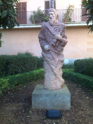
DomHenrique of Portugal, Duke of Viseu, better known as Prince Henry the Navigator, was a central figure in the early days of the Portuguese Empire and in the 15th-century European maritime discoveries and maritime expansion. Through his administrative direction, he is regarded as the main initiator of what would be known as the Age of Discovery. Henry was the fourth child of the Portuguese King John I, who founded the House of Aviz.

<span class="mw-page-title-main">History of Portugal (1415–1578)</span> Aspect of history

The history of the Kingdom of Portugal from the Illustrious Generation of the early 15th century to the fall of the House of Aviz in the late 16th century has been named the "Portuguese golden age" and the "Portuguese Renaissance". During this period, Portugal was the first European power to begin building a colonial empire as Portuguese sailors and explorers discovered an eastern route to India as well as several Atlantic archipelagos and colonized the African coast and Brazil. They also explored the Indian Ocean and established trading routes throughout most of southern Asia, sending the first direct European maritime trade and diplomatic missions to Ming China and to Japan, at the same time installing trading posts and the most important colony: Portuguese Macau. The Portuguese Renaissance produced a plethora of poets, historians, critics, theologians, and moralists. The Cancioneiro Geral by Garcia de Resende is taken to mark the transition from Old Portuguese to the modern Portuguese language.

<span class="mw-page-title-main">Jehuda Cresques</span> Cartographer from Palma, Majorca

Jehudà Cresques, also known as Jafudà Cresques, Jaume Riba, and Cresques lo Juheu, was a converso cartographer in the early 15th century.

<span class="mw-page-title-main">Conquistador</span> Soldiers and explorers for the Spanish and Portuguese empires

Conquistadors or conquistadores were the explorer-soldiers of the Spanish and Portuguese Empires of the 15th and 16th centuries. During the Age of Discovery, conquistadors sailed beyond Europe to the Americas, Oceania, Africa, and Asia, colonizing and opening trade routes. They brought much of the Americas under the dominion of Spain and Portugal.

<span class="mw-page-title-main">Caravel</span> Type of sailing ship

The caravel is a small maneuverable sailing ship used in the 15th century by the Portuguese to explore along the West African coast and into the Atlantic Ocean. The lateen sails gave it speed and the capacity for sailing windward (beating). Caravels were used by the Portuguese and Castilians for the oceanic exploration voyages during the 15th and 16th centuries, during the Age of Discovery.

<span class="mw-page-title-main">Antillia</span> 15th-century phantom island

Antillia is a phantom island that was reputed, during the 15th-century age of exploration, to lie in the Atlantic Ocean, far to the west of Portugal and Spain. The island also went by the name of Isle of Seven Cities.

<span title="Portuguese-language text"><i lang="pt">Volta do mar</i></span> Archaic navigational technique

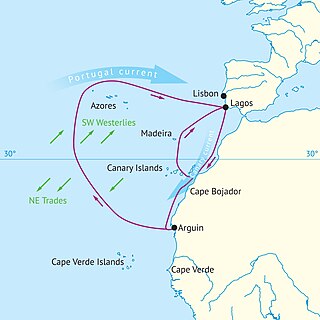
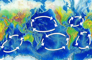
Volta do mar, volta do mar largo, or volta do largo is a navigational technique perfected by Portuguese navigators during the Age of Discovery in the late fifteenth century, using the dependable phenomenon of the great permanent wind circle, the North Atlantic Gyre. This was a major step in the history of navigation, when an understanding of winds in the age of sail was crucial to success: the European sea empires would not have been established without an understanding of the trade winds.

<span class="mw-page-title-main">Diogo Ribeiro</span>

Diogo Ribeiro was a Portuguese cartographer and explorer who worked most of his life in Spain where he was known as Diego Ribero. He worked on the official maps of the Padrón Real from 1518 to 1532. He also made navigation instruments, including astrolabes and quadrants.

<span class="mw-page-title-main">Pedro Reinel</span> Portuguese cartographer

Pedro Reinel was a Portuguese cartographer. Between 1485 and 1519 Reinel served three Portuguese kings: João II, Manuel I and João III. He and his son, Jorge Reinel, were among the most renowned cartographers of their era, a period when European knowledge of geography and cartography were expanding rapidly. There is some evidence he was of African descent. Historian Rafael Moreira believes Reinel's father was an ivory carver brought from West Africa to serve in the royal workshops.

<span class="mw-page-title-main">History of the Azores</span> History of the Azores

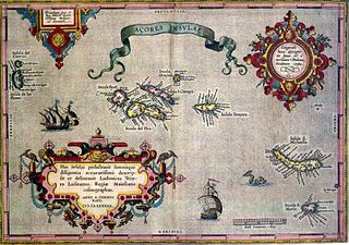
The following article describes the history of the Azores.

<span class="mw-page-title-main">History of navigation</span> Intersection of history and navigation

The history of navigation, or the history of seafaring, is the art of directing vessels upon the open sea through the establishment of its position and course by means of traditional practice, geometry, astronomy, or special instruments. Many peoples have excelled as seafarers, prominent among them the Austronesians, the Harappans, the Phoenicians, the Iranians, the ancient Greeks, the Romans, the Arabs, the ancient Indians, the Norse, the Chinese, the Venetians, the Genoese, the Hanseatic Germans, the Portuguese, the Spanish, the English, the French, the Dutch, and the Danes.

<span class="mw-page-title-main">Portuguese maritime exploration</span> Numerous territories and maritime routes recorded by the Portuguese

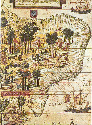
Portuguese maritime exploration resulted in the numerous territories and maritime routes recorded by the Portuguese as a result of their intensive maritime journeys during the 15th and 16th centuries. Portuguese sailors were at the vanguard of European exploration, chronicling and mapping the coasts of Africa and Asia, then known as the East Indies, and Canada and Brazil, in what came to be known as the Age of Discovery.

<span class="mw-page-title-main">Majorcan cartographic school</span> Medieval naval group

"Majorcan cartographic school" is the term coined by historians to refer to the collection of predominantly Jewish cartographers, cosmographers and navigational instrument-makers and some Christian associates that flourished in Majorca in the 13th, 14th and 15th centuries until the expulsion of the Jews. The label is usually inclusive of those who worked in Catalonia. The Majorcan school is frequently contrasted with the contemporary Italian cartography school.

<span class="mw-page-title-main">Lopo Homem</span> 16th century Portuguese cartographer

Lopo Homem was a 16th-century Portuguese cartographer and cosmographer based in Lisbon and best known for his work on the Miller Atlas.

<span class="mw-page-title-main">7th Portuguese India Armada (Almeida, 1505)</span>

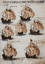
The Seventh India Armada was assembled in 1505 on the order of King Manuel I of Portugal and placed under the command of D. Francisco de Almeida, the first Portuguese Viceroy of the Indies. The 7th Armada set out to secure the dominance of the Portuguese navy over the Indian Ocean by establishing a series of coastal fortresses at critical points – Sofala, Kilwa, Anjediva, Cannanore – and reducing cities perceived to be local threats.

<span class="mw-page-title-main">Iberian ship development, 1400–1600</span> Technological development due to wars

Due to centuries of constant conflict, warfare and daily life in the Iberian Peninsula were interlinked. Small, lightly equipped armies were maintained at all times. The near-constant state of war resulted in a need for maritime experience, ship technology, power, and organization. This led the Crowns of Aragon, Portugal, and later Castile, to put their efforts into the sea.

<span class="mw-page-title-main">Zuane Pizzigano</span>

Zuane Pizzigano, was a 15th-century Venetian cartographer. He is the author of a famous 1424 portolan chart, the first known to depict the phantom islands of the purported Antillia archipelago, in the north Atlantic Ocean.

<span class="mw-page-title-main">Miller Atlas</span>

The Miller Atlas, also known as Lopo Homem-Reineis Atlas, is a richly illustrated Portuguese partial world atlas dated from 1519, including a dozen charts. It is a joint work of the cartographers Lopo Homem, Pedro Reinel and Jorge Reinel, and illustrated by miniaturist António de Holanda.

<span class="mw-page-title-main">Square-rigged caravel</span>

The square-rigged caravel, was a sailing ship created by the Portuguese in the second half of the fifteenth century. A much larger version of the caravel, its use was most notorious beginning in the end of that century. The square-rigged caravel held a notable role in the Portuguese expansion during the age of discovery, especially in the first half of the sixteenth century, for its exceptional maneuverability and combat capabilities. This ship was also sometimes adopted by other European powers. The hull was galleon-shaped, and some experts consider this vessel a forerunner of the fighting galleon, by the name of caravela de armada.

<span class="mw-page-title-main">Sagres school</span> Portuguese naval organization

The School of Sagres, also called Court of Sagres is supposed to have been a group of figures associated with fifteenth century Portuguese navigation, gathered by prince Henry of Portugal in Sagres near Cape St. Vincent, the southwestern end of the Iberian Peninsula, in the Algarve.

References