A combe can refer either to a steep, narrow valley, or to a small valley or large hollow on the side of a hill; in any case, it is often understood simply to mean a small valley through which a watercourse does not run. The word "combe" derives from Old English cumb, of the same meaning, and is unrelated to the English word "comb". It derives ultimately from the same Brythonic source as the Welsh cwm, which has the same meaning. Today, the word is used mostly in reference to the combes of southern and southwestern England.
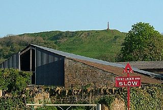
Ham Hill is a geological Site of Special Scientific Interest (SSSI), Scheduled Ancient Monument, Iron Age hill fort, Roman site, Local Nature Reserve and country park, to the west of Yeovil in Somerset, England.

The Blackdown Hills National Landscape is a National Landscape along the Somerset-Devon border in south-western England, which were designated in 1991 as an Area of Outstanding Natural Beauty (AONB). In November 2023, it has become 'Blackdown Hills National Landscape' The area encompasses a set of hills of the same name.

Pitminster is a village and civil parish in Somerset, England, situated 4 miles (6.4 km) south of Taunton. The parish has a population of 956. The parish also includes the villages of Angersleigh, Blagdon Hill and Staplehay. The village of Blagdon is now officially known as Blagdon Hill to distinguish it from Blagdon in North Somerset. Hillside hamlets in the parish comprise Feltham and Woodram, those on the lower plain in the north are Sellicks Green which is contiguous with Blagdon Hill, Duddlestone and Poundisford.

Buckland St Mary is a village and parish in Somerset, England, situated 6 miles (9.7 km) to the west of Ilminster and 8 miles (12.9 km) south of Taunton in the South Somerset district, close to the A303. The village has a population of 521. The parish is within the Blackdown Hills Area of Outstanding Natural Beauty and includes the hamlet of Birchwood.

Combe St Nicholas is a village and parish in Somerset, England, situated 2 miles (3.2 km) northwest of Chard and 10 miles (16 km) from Taunton in the South Somerset district on the edge of the Blackdown Hills Area of Outstanding Natural Beauty. The parish, which includes Wadeford and Scrapton, has a population of 1,373.

Somerset is a rural county in the southwest of England, covering 4,171 square kilometres (1,610 sq mi). It is bounded on the north-west by the Bristol Channel, on the north by Bristol and Gloucestershire, on the north-east by Wiltshire, on the south-east by Dorset, and on the south west and west by Devon. It has broad central plains with several ranges of low hills. The landscape divides into four main geological sections from the Silurian through the Devonian and Carboniferous to the Permian which influence the landscape, together with water-related features.

Black Down and Sampford Commons is a 155.2-hectare (384-acre) biological Site of Special Scientific Interest in Devon and Somerset, notified in 1952.
Deadman is a 28.8 hectare biological Site of Special Scientific Interest on the edge of the Blackdown Hills, near Buckland St Mary 5 miles (8.0 km) south of Taunton in Somerset, notified in 1987.

Freshmoor is an 11.2 hectare biological Site of Special Scientific Interest in Somerset, notified in 1989.
Long Lye is an 11.7 hectare biological Site of Special Scientific Interest at Buckland St Mary in the Blackdown Hills, Somerset, notified in 1988.
Long Lye Meadow is a 3.3 hectare biological Site of Special Scientific Interest at Buckland St Mary in the Blackdown Hills, Somerset, notified in 2002.
Ringdown is a 4.0 hectare (9.9 acre) biological Site of Special Scientific Interest west of Burnworthy in the Blackdown Hills of Somerset, notified in 1990.

Ruttersleigh is a 97 hectares biological Site of Special Scientific Interest between Buckland St Mary and Staple Fitzpaine on the north-facing slope of the Blackdown Hills. in Somerset, notified in 1991.
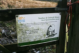
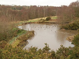
Southey and Gotleigh Moors is an 81.3 hectare biological Site of Special Scientific Interest on the Blackdown Hills in Somerset, notified in 1988.

Blackdown is a small village in western Dorset, England; situated 7 miles (11 km) west of Beaminster. With the creation of the new Dorset Council, Blackdown is now part of the new Marshwood Vale Ward. The local travel links are located 5 miles (8.0 km) from the village to Crewkerne railway station and 25 miles (40 km) to Exeter International Airport. The main road through the village is the B3165, connecting Blackdown and Lyme Regis. The village has a population of 128 according to the 2001 Census. The village and surrounding area makes up the Blackdown ward of the Broadwindsor Group Parish Council which besides the few houses in Blackdown includes Kittwhistle, Templeman's Ash (part), Laymore (part), Coles Cross, Causeway Lane, Venn, Southcoombe, Stoney Knapp, Schoolhouse Lane, Speckets Lane, Racedown, Cockpit, Horn Ash, Berechapel, two houses in Synderford, some houses in Birdsmoregate including the old Rose & Crown Public House now a private residence. The area is split between many postcodes partly due to the County boundary being realigned in the 1960s. Residents have postcodes with the main town as either Beaminster, Bridport, Crewkerne or Chard. Divisions also arise within telephone exchange areas, the BT phone box was removed from the centre of Blackdown in March 2017. Water services are provided by either South West Water or Wessex Water.

The county of Somerset is in South West England, bordered by the Bristol Channel and the counties of Bristol and Gloucestershire to the north, and Wiltshire to the east, Dorset to the south, and Devon to the west. The climate, influenced by its proximity to the Atlantic Ocean and the prevailing westerly winds, tends to be mild, damp and windy.
Yarcombe is a village and civil parish in the county of Devon, England, situated in the East Devon administrative district on the A30 road near the towns of Honiton and Chard. It is sited in the steep rolling meadows and ancient woods of the Yarty Valley on the south edge of the Blackdown Hills, an Area of Outstanding Natural Beauty. The population according to the 2011 census was 500.

The Yeovil Scarplands are a natural region in southern England in the counties of Somerset and Dorset.

