Rand, West Virginia

Last updated

Rand
RAND, WV., WITH MUCH OF ITS POPULATION LIVING IN POVERTY, HAS MANY UNPAVED ROADS, SUBSTANDARD HOUSES, AND JUNKED... - NARA - 551001.jpg
Street scene in Rand in the 1970s
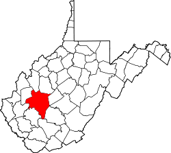
Kanawha County West Virginia incorporated and unincorporated areas Rand highlighted.svg
Location in Kanawha County and state of West Virginia.
Coordinates: 38°16′57″N81°33′44″W / 38.28250°N 81.56222°W / 38.28250; -81.56222
Country United States
State West Virginia
County Kanawha
Area
[1]
  Total
0.461 sq mi (1.19 km2)
  Land0.461 sq mi (1.19 km2)
  Water0 sq mi (0 km2)
Population
 (2010) [2]
  Total
1,631
  Density3,500/sq mi (1,400/km2)
Time zone UTC-5 (Eastern (EST))
  Summer (DST) UTC-4 (EDT)

Rand is a census-designated place (CDP) on the Kanawha River in Kanawha County, West Virginia, United States. As of the 2010 census, its population was 1,631. [2] It is surrounded by the communities of Malden and DuPont City.
Contents

History

The unincorporated community within the historic Kanawha Salines area, was named after Plus Rand Levi, son of Mordecai Levi, patent holder of the Brick Road. It was originally named "Plus" from 1907 to 1909, when a large tract was purchased from the Dickinson family. Because there was already a town already called Plus, the community changed its name to Levi. Around the 1930s or 1940s, due to a town in Braxton County being named Levi, the community changed its name again, to Rand. [3] [4]

Notable people

Pro Football Hall of Fame wide receiver and ESPN analyst Randy Moss was born and raised in Rand, as well as Samuel Singleton Jr, a former minor league baseball player. [5] [6]

The ESPN Films production Rand University, which chronicled Moss’ journey from Rand to the National Football League, was largely filmed in Rand; the title refers to the area behind the town’s only hangout spot, a 7-Eleven store where many locals openly drink alcohol behind the store’s dumpsters. [6]

Related Research Articles

<span class="mw-page-title-main">Charleston, West Virginia</span> Capital and most populous city of West Virginia, US

Charleston is the capital and most populous city of the U.S. state of West Virginia and the seat of Kanawha County. Located at the confluence of the Elk and Kanawha rivers. The population was 48,864 at the 2020 census. According to 2023 census estimates, the city is estimated to have a population of 46,838. The Charleston metropolitan area had 203,164 residents in 2023.

<span class="mw-page-title-main">Mason County, West Virginia</span> County in West Virginia, United States

Mason County is a county in the U.S. state of West Virginia. As of the 2020 census, the population was 25,453. Its county seat and largest city is Point Pleasant. The county was founded in 1804 and named for George Mason, delegate to the U.S. Constitutional Convention. Before the Civil War, the county was in the State of Virginia.

<span class="mw-page-title-main">Kanawha County, West Virginia</span> County in West Virginia, United States

Kanawha County is a county in the U.S. state of West Virginia. As of the 2020 census, the population was 180,745, making it West Virginia's most populous county. The county seat is Charleston, which is also the state capital and most populous city. Kanawha County is part of the Charleston, WV Metropolitan Statistical Area.

<span class="mw-page-title-main">Floyd County, Virginia</span> County in Virginia, United States

Floyd County is a county located in the Commonwealth of Virginia. As of the 2020 census, the population was 15,476. Its county seat is the town of Floyd. Floyd County is included in the Blacksburg-Christiansburg, VA Metropolitan Statistical Area.

<span class="mw-page-title-main">Belle, West Virginia</span> Town in West Virginia, United States

Belle is a town in Kanawha County, West Virginia, United States, situated along the Kanawha River. The population was 1,171 at the 2020 census. Belle was incorporated on December 13, 1958, by the Kanawha County Circuit Court. It is the home of the Belle Bulldogs Elementary School.

<span class="mw-page-title-main">East Bank, West Virginia</span> Town in West Virginia, United States

East Bank is a town in Kanawha County, West Virginia, United States, situated along the Kanawha River. The population was 820 at the 2020 census. East Bank was incorporated in 1889 by special charter enacted by the West Virginia Legislature. It is so named on account of the town's location on the east side of the Kanawha River.

<span class="mw-page-title-main">Elkview, West Virginia</span> Census-designated place in West Virginia, United States

Elkview is a census-designated place (CDP) in Kanawha County, West Virginia, United States. The population was 1,222 at the 2010 census. It is named after the Elk River, which flows into the Kanawha River.

<span class="mw-page-title-main">Marmet, West Virginia</span> Town in West Virginia, United States

Marmet is a town in Kanawha County, West Virginia, United States, along the Kanawha River. The population was 1,501 at the 2020 census.

<span class="mw-page-title-main">Pinch, West Virginia</span> Census-designated place in West Virginia, United States

Pinch is a census-designated place (CDP) in Kanawha County, West Virginia, United States. The population was 3,262 at the 2010 census.

<span class="mw-page-title-main">Sissonville, West Virginia</span> Census-designated place in West Virginia, United States

Sissonville is a census-designated place (CDP) in Kanawha County, West Virginia, United States, along the Pocatalico River. The population was 4,028 at the 2010 census. Sissonville is located within 14 miles of Charleston, the state capital.

<span class="mw-page-title-main">Alum Creek, West Virginia</span> Census-designated place in West Virginia, United States

Alum Creek is a census-designated place (CDP) in Kanawha and Lincoln counties along the Coal River in the U.S. state of West Virginia. It includes the unincorporated communities of Alum Creek, Forks of Coal, and Priestley. The CDP had a population of 1,749 at the 2010 census, down from 1,839 at the 2000 census.

<span class="mw-page-title-main">Montgomery, West Virginia</span> City in West Virginia

Montgomery is a city in West Virginia, United States, along the Kanawha River. Most of the city is in Fayette County, with the remainder in Kanawha County. The population was 1,280 at the 2020 census.

<span class="mw-page-title-main">Nitro, West Virginia</span> City in West Virginia, United States

Nitro is a city in Kanawha and Putnam counties in the U.S. state of West Virginia. It takes its name from a World War I era nitrocellulose plant. The population was 6,618 according to the 2020 census. It is part of the Charleston metropolitan area.

Malden — originally called Kanawha Salines — is an unincorporated community in Kanawha County, West Virginia, United States, within the Charleston metro area.

<span class="mw-page-title-main">Glen Ferris, West Virginia</span> Census-designated place in West Virginia, United States

Glen Ferris is a census-designated place (CDP) on the western bank of the Kanawha River in Fayette County, West Virginia, United States. It is situated approximately one mile south of the town of Gauley Bridge and adjacent to Kanawha Falls. The sole highway linking Glen Ferris to the area is U.S. Route 60, known also as the Midland Trail. As of the 2010 census, its population was 203; the community had 104 housing units, 87 of which were occupied. The village is roughly a mile and a half in length. Glen Ferris is home to two churches, one Apostolic and one Methodist. A railway owned by Norfolk Southern runs parallel to US Route 60 through the village.

<span class="mw-page-title-main">Chelyan, West Virginia</span> Census-designated place in West Virginia, United States

Chelyan is a census-designated place (CDP) in Kanawha County, West Virginia, United States. Chelyan is located on the south bank of the Kanawha River, southeast of Chesapeake. It is served by Exit 85 of the West Virginia Turnpike. As of the 2010 census, its population was 776.

<span class="mw-page-title-main">Shrewsbury, West Virginia</span> Census-designated place in West Virginia, United States

Shrewsbury is a census-designated place (CDP) and unincorporated community in Kanawha County, West Virginia, United States. Shrewsbury is located on the north bank of the Kanawha River along U.S. Route 60. As of the 2010 census, its population was 652.

<span class="mw-page-title-main">Boomer, West Virginia</span> Census-designated place in West Virginia, United States

Boomer is a census-designated place (CDP) in Fayette County, West Virginia, United States. Boomer is located on the north bank of the Kanawha River, 2 miles (3.2 km) southeast of Smithers. Boomer has a post office with ZIP code 25031. As of the 2010 census, its population was 615.

<span class="mw-page-title-main">Cooper District, Mason County, West Virginia</span> Magisterial district in West Virginia, United States

Cooper Magisterial District is one of ten magisterial districts in Mason County, West Virginia, United States. The district was originally established as a civil township in 1863, and converted into a magisterial district in 1872. In 2020, Cooper District was home to 1,700 people.

References

  1. "US Gazetteer files: 2010, 2000, and 1990". United States Census Bureau. February 12, 2011. Retrieved April 23, 2011.
  2. 1 2 "U.S. Census website". United States Census Bureau . Retrieved May 14, 2011.
  3. Kenny, Hamill (1945). West Virginia Place Names: Their Origin and Meaning, Including the Nomenclature of the Streams and Mountains. Piedmont, WV: The Place Name Press. p. 493.
  4. Year: 1940; Census Place: Malden, Kanawha, West Virginia; Roll: T627_4416; Page: 32B; Enumeration District: 20-111
  5. Bieler, Des (November 12, 2014). "What we learned from ESPN's '30 for 30′ on Randy Moss". The Washington Post. Retrieved March 27, 2016.
  6. 1 2 McGarry, Tim (September 17, 2012). "Randy Moss remembers his roots with Rand University". USA Today. Retrieved March 27, 2016.