Senachwine Township, Putnam County, Illinois

Last updated

Senachwine Township
Township
Map highlighting Senachwine Township, Putnam County, Illinois.svg
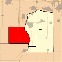
Location in Putnam County
Map of Illinois highlighting Putnam County.svg
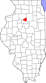
Putnam County's location in Illinois
Country United States
State Illinois
County Putnam
EstablishedNovember 8, 1855
Area
  Total
40.07 sq mi (103.8 km2)
  Land31.86 sq mi (82.5 km2)
  Water8.21 sq mi (21.3 km2)  20.49%
Population
 (2010)
  Estimate 
(2016) [1]
712
  Density23.4/sq mi (9.0/km2)
Time zone UTC-6 (CST)
  Summer (DST) UTC-5 (CDT)
FIPS code 17-155-68627

Senachwine Township is located in Putnam County, Illinois. As of the 2010 census, its population was 745 and it contained 651 housing units. [2]

Contents

Senachwine is named for an Indian chief whose hunting grounds and home were located in the township. [3]

Geography

According to the 2010 census, the township has a total area of 40.07 square miles (103.8 km2), of which 31.86 square miles (82.5 km2) (or 79.51%) is land and 8.21 square miles (21.3 km2) (or 20.49%) is water. [2]

Demographics

Historical population
CensusPop.Note
2016 (est.)712 [1]
U.S. Decennial Census [4]

References

  1. 1 2 "Population and Housing Unit Estimates" . Retrieved June 9, 2017.
  2. 1 2 "Population, Housing Units, Area, and Density: 2010 - County -- County Subdivision and Place -- 2010 Census Summary File 1". United States Census. Archived from the original on February 12, 2020. Retrieved May 28, 2013.
  3. Warren, Vallette (1887). History of Putnam County (PDF). The Record Job Printing Office. p. 6.
  4. "Census of Population and Housing". Census.gov. Retrieved June 4, 2016.

41°11′27″N89°23′59″W / 41.19083°N 89.39972°W / 41.19083; -89.39972