Springfield, New York | |
---|---|
Coordinates: 42°50′10″N74°51′13″W / 42.83611°N 74.85361°W | |
Country | United States |
State | New York |
County | Otsego |
Settled | 1762 |
Established | 1797 |
Area | |
• Total | 45.51 sq mi (117.86 km2) |
• Land | 42.89 sq mi (111.09 km2) |
• Water | 2.61 sq mi (6.77 km2) 5.46% |
Elevation | 1,322 ft (403 m) |
Population (2010) | |
• Total | 1,358 |
• Estimate (2016) [2] | 1,294 |
• Density | 30.17/sq mi (11.65/km2) |
Time zone | UTC-5 (Eastern (EST)) |
• Summer (DST) | UTC-4 (EDT) |
ZIP code | 13468 13468 |
Area code | 607 |
FIPS code | 36-70310 |
GNIS feature ID | 0979514 |
Springfield is a town in Otsego County, New York, United States. The population was 1,358 at the 2010 census.
The Town of Springfield is located at the northern county line of Otsego County and is approximately 50 mi (80 km) west of Schenectady.
Several families settled near Otsego Lake circa 1762, but little further development occurred until after the American Revolution. In 1778, Joseph Brant, native leader, led an expedition that burned the town and took captives. Lieutenant Colonel Jacob Ford wrote a letter to General Abraham Ten Broeck informing him of the destruction of Springfield. [3]
The Town of Springfield was formed from part of the Town of Cherry Valley in 1797. Growing hops was a major agricultural pursuit.
According to the United States Census Bureau, the town has a total area of 45.5 square miles (118 km2), of which 43.0 square miles (111 km2) is land and 2.5 square miles (6.5 km2) (5.46%) is water.
The town encloses the northern end of Otsego Lake. Hayden Creek flows southward from Summit Lake into the northern end of the Otsego Lake. Because Summit Lake is located on a divide, part of its flow exits from the northern end of the lake through Cedar Swamp into Otsquago Creek. The "Chyle", is the name of a sinkhole located northwest of Summit Lake. Shadow Brook enters Otsego Lake at Hyde Bay.
New York State Route 80, a north–south highway, intersects US Route 20, an east–west highway, north of Springfield Center.
The northern town line is the county line of Herkimer County and a small section of Montgomery County.
Census | Pop. | Note | %± |
---|---|---|---|
1820 | 2,065 | — | |
1830 | 2,816 | 36.4% | |
1840 | 2,382 | −15.4% | |
1850 | 2,322 | −2.5% | |
1860 | 2,390 | 2.9% | |
1870 | 2,022 | −15.4% | |
1880 | 2,616 | 29.4% | |
1890 | 1,726 | −34.0% | |
1900 | 1,762 | 2.1% | |
1910 | 1,468 | −16.7% | |
1920 | 1,287 | −12.3% | |
1930 | 1,305 | 1.4% | |
1940 | 1,135 | −13.0% | |
1950 | 1,184 | 4.3% | |
1960 | 1,121 | −5.3% | |
1970 | 1,136 | 1.3% | |
1980 | 1,239 | 9.1% | |
1990 | 1,267 | 2.3% | |
2000 | 1,350 | 6.6% | |
2010 | 1,358 | 0.6% | |
2016 (est.) | 1,294 | [2] | −4.7% |
U.S. Decennial Census [4] |
As of the census [5] of 2000, there were 1,350 people, 521 households, and 375 families residing in the town. The population density was 31.4 inhabitants per square mile (12.1/km2). There were 712 housing units at an average density of 16.6 per square mile (6.4/km2). The racial makeup of the town was 98.59% White, 0.15% African American, 0.07% Native American, 0.22% Asian, 0.15% from other races, and 0.81% from two or more races. Hispanic or Latino of any race were 1.19% of the population.
There were 521 households, out of which 32.4% had children under the age of 18 living with them, 60.1% were married couples living together, 6.5% had a female householder with no husband present, and 28.0% were non-families. 22.6% of all households were made up of individuals, and 12.7% had someone living alone who was 65 years of age or older. The average household size was 2.59 and the average family size was 3.04.
In the town, the population was spread out, with 26.2% under the age of 18, 5.3% from 18 to 24, 25.3% from 25 to 44, 25.7% from 45 to 64, and 17.4% who were 65 years of age or older. The median age was 42 years. For every 100 females, there were 98.8 males. For every 100 females age 18 and over, there were 99.6 males.
The median income for a household in the town was $33,854, and the median income for a family was $38,490. Males had a median income of $25,625 versus $23,611 for females. The per capita income for the town was $16,513. About 5.6% of families and 8.5% of the population were below the poverty line, including 10.8% of those under age 18 and 5.4% of those age 65 or over.
Arietta is a town in Hamilton County, New York, United States. The population was 304 at the 2010 census. The town was named after the mother of one of the first settlers, Rensselaer Van Rennslaer.
Indian Lake is a town in Hamilton County, New York, United States. The population was 1,352 at the 2010 census. The name is from a lake of the same name that is largely inside the town. There are no permanent stop lights in the town. Law enforcement is provided by New York State Troopers and Hamilton County Sheriff's Office.
Columbia is a town in Herkimer County, New York, United States. As of the 2020 census, the town population was 1,569. The town is at the southern border of the county and is southeast of Utica.
Ohio is a town in Herkimer County, New York, United States. The population was 1,002 at the 2010 census. The town is named after the state of Ohio. The town is in the northern part of the county and northeast of Utica. Part of Ohio is within the Adirondack Park.
Warren is a town in Herkimer County, New York, United States. The population was 1,143 at the 2010 census. The town is named after General Joseph Warren, who was killed at the Battle of Bunker Hill. Warren is in the south part of Herkimer County. US 20 passes across the town.
Webb is the northernmost town in Herkimer County, New York, United States. As of the 2010 census it had a population of 1,807.
Burlington is a town in Otsego County, New York, United States. The population was 1,140 at the 2010 census.
Exeter is a town in Otsego County, New York, United States. The town is located in the northern part of the county. The population was 987 at the 2010 census. It is named after the county town and cathedral city of Exeter in England.
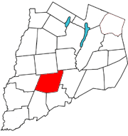
Hartwick is a town located in Otsego County, New York, United States. As of the 2010 census, the town had a population of 2,110. The Town of Hartwick is located in the middle of the county, southwest of the Village of Cooperstown.
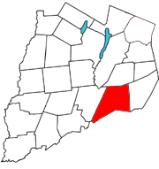
Maryland is a town in Otsego County, New York, United States. The population was 1,897 at the 2010 census. It was named for the U.S. state of the same name. The Town of Maryland is on the county's southern border. It is northeast of the City of Oneonta.
Middlefield is a town in Otsego County, New York, United States. The population was 2,114 at the 2010 census.
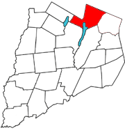
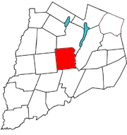
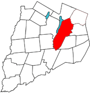
Otsego is a town in the north-central part of Otsego County, New York, United States. The population was 3,641 at the 2020 census. The town is named after Lake Otsego, which forms part of the town's eastern border.
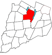
Richfield is a town located in Otsego County, New York, United States. As of the 2010 census, the town had a population of 2,388. The Town of Richfield is located at the northern border of the county.
Worcester is a town in Otsego County, New York, United States. The population was 2,220 at the 2010 census. Worcester is on the southeastern border of the county and is northeast of Oneonta. The Worcester Central School District presently has 369 students enrolled in grades K-12.
Summit is a town in Schoharie County, New York, United States. The population was 1,072 at the time of the 2020 census. The name is derived from a peak that was thought to be the highest elevation in the county.
Piercefield is a town in St. Lawrence County, New York, United States. The population was 310 at the 2010 census.
Dresden is a town in northern Washington County, New York, United States. It is part of the Glens Falls Metropolitan Statistical Area. The town population was 677 at the 2000 census.
Laurens is a town in Otsego County, New York, United States. The population was 2,424 at the 2010 census.
Milford is a town in Otsego County, New York, United States. The population was 3,044 at the 2010 census. Within town is the village of Milford. The town is northeast of the City of Oneonta.
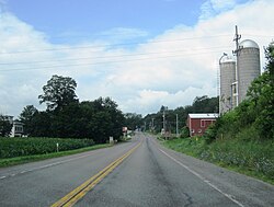
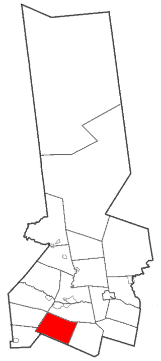
Unadilla is a town in Otsego County, New York, United States. As of the 2010 census, the town had a population of 4,392. The name is derived from an Iroquois word for "meeting place". Unadilla is located in the southwestern corner of the county, southwest of Oneonta. The village of Unadilla is located in the southern part of the town. The mayor of Unadilla is Jason Cotten.
data