Stafford Springs | |
|---|---|
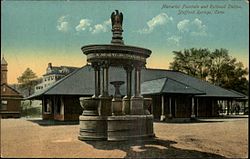 The Holt Memorial Fountain circa. 1910 | |
 Location in Tolland County and the state of Connecticut | |
| Coordinates: 41°57′12″N72°18′11″W / 41.9534°N 72.3030°W | |
| Country | |
| State | |
| County | Tolland |
| Region | Capitol Region |
| Town | Stafford |
| Area | |
• Total | 6.41 sq mi (16.6 km2) |
| • Land | 6.37 sq mi (16.5 km2) |
| • Water | 0.036 sq mi (0.093 km2) |
| Elevation | 607 ft (185 m) |
| Population (2020) | |
• Total | 11,000 |
| • Density | 1,700/sq mi (660/km2) |
| Time zone | UTC−5 (Eastern (EST)) |
| • Summer (DST) | UTC−4 (EDT) |
| ZIP code | 06076 |
| Area code | 860 |
| FIPS code | 09-72300 |
| GNIS feature ID | 2377866 [1] |
| Website | staffordct |
Stafford Springs is a census-designated place located in Stafford, Connecticut, United States. The population was 4,780 at the 2020 Census. [2] The village was a borough until November 1991, when it was disincorporated. [3]
Contents
Located near the source of the Willimantic River, [4] the mill industry grew in the town due to its location and became the largest industry in the area. [5] The village has the Holt Memorial Fountain and the former railroad station. [6] A portion of the village center was listed on the National Register of Historic Places in 2025. [7]
In the 18th century, the spring at Stafford Springs was famous for its reputed ability to cure "the gout, sterility, pulmonary, hysterics, etc." [8] In 1771, John Adams, then a young lawyer, visited Stafford Springs for several days after suffering from overwork and anxiety. [8]
Stafford Springs was once the headquarters of Station C of the Connecticut State Police, and subsequently was the site of the Troop C Barracks. [9]
Currently Route 32, Route 190, Route 19, and Route 140 pass through or originate in the village. [10]
