
Mission Beach is a coastal town and locality in the Cassowary Coast Region, Queensland, Australia. In the 2016 census, the locality of Mission Beach had a population of 815 people.
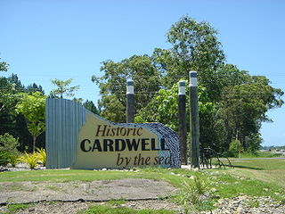
Cardwell is a coastal town and rural locality in the Cassowary Coast Region, Queensland, Australia. In the 2016 census, the locality of Cardwell had a population of 1,309 people.
Tam o' Shanter may refer to:
Mundoo is a rural town and locality in the Cassowary Coast Region, Queensland, Australia. In the 2016 census the locality of Mundoo had a population of 224 people.
Tam O'Shanter Point is a headland located in South Mission Beach, Cassowary Coast Region, Queensland, Australia on the north-eastern part of Rockingham Bay in the Coral Sea. It is part of the Coastal Wet Tropics Important Bird Area, identified as such by BirdLife International because of its importance for the conservation of lowland tropical rainforest birds.

South Johnstone is a rural town and locality in the Cassowary Coast Region, Queensland, Australia. In the 2016 census, South Johnstone had a population of 413 people.
Cowley Beach is a beach, coastal town and locality in the Cassowary Coast Region, Queensland, Australia. In the 2016 census the locality of Cowley Beach had a population of 78 people.

Bingil Bay is a coastal town, locality and bay in the Cassowary Coast Region, Queensland, Australia. In the 2016 census the locality of Bingil Bay had a population of 427 people.
Garners Beach is a coastal locality in the Cassowary Coast Region, Queensland, Australia. In the 2016 census, Garners Beach had a population of 25 people.

Daradgee is a rural town and locality in the Cassowary Coast Region, Queensland, Australia. In the 2016 census, Daradgee had a population of 74 people.
Wongaling Beach is a tropical beachside coastal town and locality in the Cassowary Coast Region, Queensland, Australia. In the 2016 census, the locality of Wongaling Beach had a population of 1,245 people.

South Mission Beach is a coastal town and locality in the Cassowary Coast Region, Queensland, Australia. In the 2016 census, South Mission Beach had a population of 932 people.

Ngatjan is a locality split between the Cassowary Coast Region and the Cairns Region, Queensland, Australia. In the 2016 census, Ngatjan had no population. The term is derived from the ethnonym of the local Ngatjan people.
Hull Heads is a coastal town and locality in the Cassowary Coast Region, Queensland, Australia. In the 2016 census, Hull Heads had a population of 113 people.
Mount Mackay is a locality in the Cassowary Coast Region, Queensland, Australia. In the 2016 census, Mount Mackay had a population of 0 people.
Kurrimine Beach is a town and a locality in the Cassowary Coast Region, Queensland, Australia. In the 2016 census, Kurrimine Beach had a population of 729 people.
Mamu is a rural locality in the Cassowary Coast Region, Queensland, Australia. In the 2016 census Mamu had a population of 0 people.
Gulngai is a rural locality in the Cassowary Coast Region, Queensland, Australia. In the 2016 census, Gulngai had a population of 0 people.
Innisfail Estate is a rural locality in the Cassowary Coast Region, Queensland, Australia. In the 2016 census, Innisfail Estate had a population of 1,338 people.
Walter Hill is a rural locality in the Cassowary Coast Region, Queensland, Australia. In the 2016 census, Walter Hill had a population of 0 people.
