The Preserve

Last updated
The Preserve
The Preserve Old Saybrook Town Line Essex Land Trust.jpg
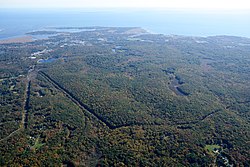
Boundary sign between Old Saybrook and Essex in "The Preserve".
Relief map USA Connecticut.png
Red pog.svg
Location in Connecticut
Usa edcp relief location map.png
Red pog.svg
The Preserve (the United States)
Location Essex, Old Saybrook & Westbrook, Connecticut, United States
Coordinates 41°19′09″N72°24′54″W / 41.31917°N 72.41500°W / 41.31917; -72.41500 [1]
Area963 acres (390 ha)
Elevation131 ft (40 m) [1]
Established2016
Administrator Connecticut Department of Energy and Environmental Protection and Essex Land Trust
Website The Preserve

The Preserve is a 963-acre open space preserve spanning the towns of Old Saybrook, Essex, and Westbrook, Connecticut. The property is owned by the State of Connecticut, Town of Old Saybrook, and the Essex Land Trust. [2] It was protected in 2015 by The Trust for Public Land [3] [4] [5] after an agreement to purchase the property from River Sound Development, LLC, was reached in 2013. [6]

According to the Connecticut Department of Energy and Environmental Protection, The Preserve, prior to its protection, was "the largest remaining unprotected coastal forest between Boston and New York." [2] The Essex Land Trust notes that The Preserve's protected ecosystems include wetlands, vernal pools, and mature coastal forests and that it is home to a diverse population of "25 species of amphibians, 30 kinds of mammals and 57 different birds". [7] It plays an important role in maintaining the water quality of Trout Brook, as well as the Oyster and Mud rivers. [6] Ten miles of hiking trails span northern and central parts of the property. [3]

Aerial view of The Preserve and Long Island Sound Aerial view of The Preserve (14028116963).jpg
Aerial view of The Preserve and Long Island Sound

Related Research Articles

<span class="mw-page-title-main">Gay City State Park</span> Connecticut State Park

Gay City State Park is a public recreation area on the Blackledge River in the towns of Hebron and Bolton, Connecticut. The state park occupies 1,569 acres (635 ha) bordering Meshomasic State Forest and is accessible from State Route 85. In addition to its deep forest, millpond, and marshland, the park bears trace remnants of the mill town that occupied the site for most of the 19th century. The park is managed by the Connecticut Department of Energy and Environmental Protection.

<span class="mw-page-title-main">Salmon River (Connecticut)</span> River in Connecticut , US

The Salmon River is formed at the confluence of the Blackledge and Jeremy rivers about one mile west of North Westchester, Connecticut. It drains 96,000 acres and courses for 10.4 miles (16.7 km) to Salmon Cove near Moodus where it flows into the Connecticut River. The Salmon River is probably the largest stream and watershed whose sources and mouth are entirely within the limits of Connecticut.

<span class="mw-page-title-main">Valley Railroad (Connecticut)</span> Heritage railway in Connecticut, United States

The Valley Railroad, operating under the name Essex Steam Train and Riverboat, is a heritage railroad based in Connecticut on tracks of the Connecticut Valley Railroad, which was founded in 1868. The company began operations in 1971 between Deep River and Essex, and has since reopened additional parts of the former Connecticut Valley Railroad line. It operates the Essex Steam Train and the Essex Clipper Dinner Train.

Joshua's Tract Conservation and Historic Trust, or Joshua's Trust, is a non-profit 501(c)(3) land trust operating in northeast Connecticut. Joshua's Trust was incorporated in 1966 to help conserve property of significant natural or historic interest. As of 2011, the Trust protects more than 5,000 acres, maintains 42 miles of trails that are open to the public, holds educational outreach programs, and publishes the Joshua's Tract Walkbook.

<span class="mw-page-title-main">Scantic River State Park</span> State park in Hartford County, Connecticut

Scantic River State Park is a public recreation area consisting of several separated parcels totaling 784 acres (317 ha) along the Scantic River in the towns of Enfield, East Windsor, and Somers, Connecticut. The state park is suitable for hiking, fishing, and hunting and is managed by the Connecticut Department of Energy and Environmental Protection.

<span class="mw-page-title-main">Lovers Leap State Park</span> State park in Litchfield County, Connecticut

Lovers Leap State Park is a public recreation area on the Housatonic River in the town of New Milford, Litchfield County, Connecticut. The state park's 127 acres (51 ha) straddle the Housatonic Gorge near the intersection of Connecticut Route 67 and Connecticut Route 202. The park offers hiking to scenic and historic locations and is managed by the Connecticut Department of Energy and Environmental Protection.

<span class="mw-page-title-main">Quinnipiac River State Park</span> State park in New Haven County, Connecticut

Quinnipiac River State Park is a public recreation area located in the town of North Haven, Connecticut. The four sections of the state park protect 6 miles (9.7 km) of the Quinnipiac River.

<span class="mw-page-title-main">Bolton Notch State Park</span> State park in Tolland County, Connecticut

Bolton Notch State Park is a public Protected recreation area located in the town of Bolton, Connecticut, on the boundary between the Thames River and Connecticut River watersheds. The state park's 95 acres (38 ha) offer opportunities for hiking, climbing, and cave exploration. Bolton Notch is located at the junction of U.S. Route 44 and U.S. Route 6 in Bolton, CT.

<span class="mw-page-title-main">Horse Guard State Park</span> State park in Hartford County, Connecticut

Horse Guard State Park is a public recreation area covering 105 acres (42 ha) in the town of Avon, Connecticut. The state park is managed by the Connecticut Department of Energy and Environmental Protection.

<span class="mw-page-title-main">Windsor Meadows State Park</span> State park in Hartford County, Connecticut

Windsor Meadows State Park is a public recreation area on the west side of the Connecticut River in the town of Windsor, Connecticut. The state park occupies three largely undeveloped sections measuring 48, 19, and 88 acres located between railroad tracks and the river. Park activities include picnicking, fishing, boating, hiking, and biking.

<span class="mw-page-title-main">Sunnybrook State Park</span> State park in Litchfield County, Connecticut

Sunnybrook State Park is a public recreation area encompassing 464 acres (188 ha) in the town of Torrington, Connecticut. The state park is the southwestern terminus for the blue-blazed John Muir Trail which crosses Paugnut State Forest for two miles to the loop trail at Burr Pond State Park. Another park trail bears the name of former property owner Edwin Fadoir. In addition to hiking, the park offers picnicking, hunting, and fishing along the East Branch Naugatuck River. The park opened in 1970 and entered the state rolls in the 1971 edition of the Connecticut Register and Manual.

<span class="mw-page-title-main">Farm River State Park</span> State park in East Haven, United States

Farm River State Park is a privately operated, publicly owned recreation area on the western shore of the Farm River estuary in the town of East Haven, Connecticut. Public access to the 62-acre state park is limited and boating is restricted to those with passes obtained from Quinnipiac University, which manages the park for the Connecticut Department of Energy and Environmental Protection. Park activities include nature trail hiking, bird watching, and fishing.

<span class="mw-page-title-main">Bluff Point State Park</span> State park in New London County, Connecticut

Bluff Point State Park is a public recreation area and nature preserve on an undeveloped peninsula located between the Poquonnock River and Mumford Cove on Long Island Sound in the town of Groton, Connecticut. The state park's 806 acres (326 ha) encompass a barrier beach, steep cliffs, forested sections, and tidal wetlands; 778 acres (315 ha) are designated as a coastal reserve. Recreational opportunities include hiking, mountain biking, boating, saltwater fishing, and shell fishing. The park is managed by the Connecticut Department of Energy and Environmental Protection.

<span class="mw-page-title-main">Haley Farm State Park</span> Public recreation area in Groton, US

Haley Farm State Park is a public recreation area that preserves Colonial-era farmland as open space in the town of Groton, Connecticut. The site of the state park once formed part of the lands granted to Governor John Winthrop and later became a dairy farm. The park's 267 acres (108 ha) are connected to the adjacent Bluff Point State Park by way of a pedestrian bridge over railroad tracks. Park activities are restricted to bicycling and walking. The park is managed by Connecticut Department of Energy and Environmental Protection.

<span class="mw-page-title-main">River Highlands State Park</span> State park in Middlesex County, Connecticut

River Highlands State Park is a public recreation area located on the west bank of the Connecticut River in the town of Cromwell, Connecticut. The 177-acre (72 ha) state park is managed by Connecticut Department of Energy and Environmental Protection.

<span class="mw-page-title-main">Sunrise State Park</span> State park in Connecticut, United States

Sunrise State Park is a public recreation area occupying the site of the former Sunrise Resort in the town of East Haddam, Connecticut. The state park encompasses 143 acres (58 ha) on the east shore of Salmon River and shares an entrance with Machimoodus State Park to the south. The park is managed by the Connecticut Department of Energy and Environmental Protection.

<span class="mw-page-title-main">Eagle Landing State Park</span> State park in Middlesex County, Connecticut

Eagle Landing State Park is a public recreation area occupying 16 acres (6.5 ha) on the west bank of the Connecticut River in the town of Haddam, Connecticut. The state park has facilities for picnicking, fishing, bird watching and car-top boating. A private concessionnaire offers river excursions from a dock in the park.

<span class="mw-page-title-main">Haddam Meadows State Park</span> State park in Middlesex County, Connecticut

Haddam Meadows State Park is a public recreation area occupying 175 acres (71 ha) on the west bank of the Connecticut River in the town of Haddam, Connecticut. The state park offers picnicking, fishing, and a boat launch. Park trails lend access to a diversity of riverside landscapes: marsh, beach, sand bar, fern growths, meadow lands, and hardwood forest. The park was established through the donation of land in 1944 by the Edward W. Hazen Foundation. It is managed by the Connecticut Department of Energy and Environmental Protection.

<span class="mw-page-title-main">James L. Goodwin State Forest</span>

James L. Goodwin State Forest is a Connecticut state forest covering approximately 2,000 acres (810 ha) in the towns of Chaplin and Hampton. The lands became public property when James L. Goodwin donated the personal forest he had been developing since 1913 to the state in 1964.

<span class="mw-page-title-main">Nassahegon State Forest</span> State forest in Connecticut, United States

Nassahegon State Forest is a Connecticut state forest occupying 1,227 acres (497 ha) in the town of Burlington.The forest is managed for forestry and recreational purposes and is operated by the Connecticut Department of Energy and Environmental Protection.

References

  1. 1 2 "Pequot Swamp Pond". Geographic Names Information System . United States Geological Survey, United States Department of the Interior.
  2. 1 2 "The Preserve". State Parks and Forests. Connecticut Department of Energy and Environmental Protection. July 18, 2016. Retrieved April 21, 2018.
  3. 1 2 Marteka, Peter (April 16, 2016). "The Preserve is officially open for passive recreation". Hartford Courant. Retrieved April 21, 2018.
  4. Hladky, Gregory B. (September 6, 2014). "Victory came hard in long battle to save The Preserve". Hartford Courant. Retrieved April 21, 2018.
  5. "The Preserve is permanently protected". The Trust for Public Land. Retrieved April 21, 2018.
  6. 1 2 "The Preserve". The Trust for Public Land. Retrieved August 3, 2018.
  7. "The Preserve". Essex Land Trust. Retrieved August 3, 2018.