Kargil district is one of two districts comprising Ladakh, India. Kargil city is the district headquarters of Kargil district. It is bounded by the union territory of Jammu and Kashmir in the west, the Pakistani territory of Gilgit–Baltistan in the north, Ladakh's Leh district to the east, and the state of Himachal Pradesh in the south. Encompassing three historical regions known as Purig, Dras and Zanskar, the district lies to the northwest of the Great Himalayas and encompasses the majority of the Zanskar Range. Its population inhabits the river valleys of the Dras, Suru, Kartse, Wakha Rong, and Zanskar.

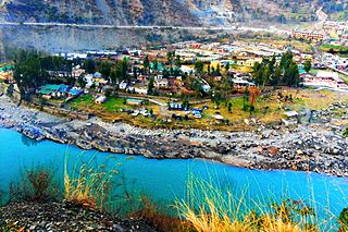
Kargil or Kargyil is a city and a joint capital of the union territory of Ladakh, India. It is also the headquarters of the Kargil district. It is the second-largest city in Ladakh after Leh. Kargil is located 204 kilometres (127 mi) east of Srinagar in Jammu and Kashmir, and 234 kilometres (145 mi) to the west of Leh. It is on the bank of the Suru River near its confluence with the Wakha Rong river, the latter providing the most accessible route to Leh.
The Suru Valley is a valley in the Kargil District in the Union Territory of Ladakh, India. It is drained by the Suru River, a tributary of the Indus River. The valley's most significant town is Sankoo.

Zangla is a village in Zanskar tehsil of Kargil district, in the Indian union territory of Ladakh. It is located 262 km from Kargil city, the district headquarter, 32 km from Padum, the capital of Zanskar and presently the headquarter of Zanskar. An ancient ruined fort, known as Zangla Fort is located on a hilltop one km outdide the village, believed to be 11th-century.

Tourism is one of an economic contributor to the union territory of Ladakh in Northern India. The union territory is sandwiched between the Karakoram mountain range to the north and the Himalayas to the south and is situated at the height of 11,400 ft. Ladakh is composed of the Leh and Kargil districts. The region contains prominent Buddhist sites and has an ecotourism industry.
Batalik is a village and military base in Ladakh, India, located in a narrow section of the Indus river valley, close to the Line of Control with Pakistan-administered Baltistan. It was a focal point of the Kargil War because of its strategic location between Kargil, Leh and Baltistan. In 1999, the Kargil war was fought in this region.
Ramban is a town in Ramban district of Jammu and Kashmir, India, which is the district headquarters of Ramban district. It lies on the banks of the Chenab river in Chenab Valley on the National Highway-1A at about 120 km from Jammu and about 130 km from Srinagar, making it almost the central point on the Jammu-Srinagar National Highway.
Poyen is a village in the Kargil district, Ladakh, in India, close to the Kargil town. It is on the right bank of Wakha Rong river near its confluence with the Suru River. The village jurisdiction includes the hamlets of Hunderman acquired from Pakistan during the Indo-Pakistan War of 1971.
Pokhraira is a village in Bokhra block of Sitamarhi District in Bihar state of India. It is surrounded by three main cities of Bihar, which are Muzaffarpur, Darbhanga and Sitamarhi. Pokhraira is 27 km distance from district main city Sitamarhi and 97 km distance from state capital Patna.
Hunderman or Hundarmaan or Hundurmaan is one of the northernmost hamlets in India and is situated in the Kargil district of Ladakh. Located on the banks of the Suru River 10 km from Kargil, it is a hamlet under Shilikchey village of Kargil district.] It was under Pakistan's control until 1971. Geographically, Hunderman lies in the Baltistan Region. There are two parts of Hunderman: Lower Hunderman Mal and Hunderman Broq.
Hardas is a village in Kargil district of the Indian union territory of Ladakh, close to the India–Pakistan border (LOC). The village is located 10 kilometres north of Kargil, the district headquarters, on the left of the Dras River.
Jusgund is a village in Drass tehsil in Kargil district of the Indian union territory of Ladakh. The village is located 30 kilometres from the district headquarters Kargil.
Itchoo is a village in Sankoo tehsil in Kargil district of the Indian union territory of Ladakh. The village is located 75 kilometres from the district headquarters Kargil.
Namsuru is a village in Kargil district of the Indian union territory of Ladakh. The village is located 88 kilometres from district headquarters Kargil.
Shargole is a medium-sized village and tehsil in Kargil district of the Indian union territory of Ladakh. The village is located 30 kilometres from district headquarters Kargil.
Thasgam is a village in Drass tehsil in Kargil district of the Indian union territory of Ladakh. The village is located 36 kilometres from the district and tehsil headquarters Kargil.
Kharbu is a village in Drass tehsil in Kargil district of the Indian union territory of Ladakh. The village is located 26 kilometres from the district and tehsil headquarters Kargil.
Goshan is a village in Drass tehsil in Kargil district of the Indian union territory of Ladakh. The village is located 77 kilometres from the district headquarters Kargil.
Matayen is a village in Drass tehsil in Kargil district of the Indian union territory of Ladakh. The village is located around 21 kilometer's from drass and around 81 kilometres from the district headquarters Kargil.Its only village in ladakh where Kashmiri is spoken and Kashmiri peoples are being lived.

Patushay was initially a autonomic village in Bandipora district, Jammu and Kashmir, India. Later on it was merged with Qazipora, and formed a new Village called Qazipora Patushi. It is 4 km away from Bandipora town, and 59 km away from Srinagar. The name Patushay is derived from the word Put, meaning Old, and Shay, meaning Place of history.