Warrenville, South Carolina

Last updated

Warrenville, South Carolina
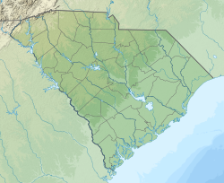
USA South Carolina location map.svg
Red pog.svg
Warrenville
Coordinates: 33°33′3″N81°48′14″W / 33.55083°N 81.80389°W / 33.55083; -81.80389
Country Flag of the United States.svg  United States of America
State Flag of South Carolina.svg  South Carolina
County Seal of Aiken County, South Carolina.png Aiken
Area
[1]
  Total1.09 sq mi (2.83 km2)
  Land1.08 sq mi (2.81 km2)
  Water0.01 sq mi (0.02 km2)
Elevation
235 ft (72 m)
Population
 (2020) [2]
  Total1,134
  Density1,046.13/sq mi (403.74/km2)
Time zone UTC-5 (Eastern (EST))
  Summer (DST) UTC-4 (EDT)
ZIP code
29851
Area code(s) 803 and 839
FIPS code 45-74725 [3]
GNIS feature ID1231893 [4]

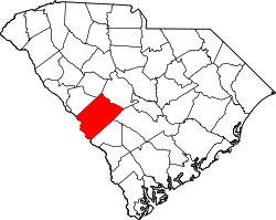
Warrenville is a census-designated place (CDP) in Aiken County, South Carolina, United States. The population was 1,233 at the 2010 census. [5] It is located just south of Graniteville and is part of the Augusta, Georgia metropolitan area. Warrenville is located in historic Horse Creek Valley.
Contents

History

In 2008, there were talks about incorporating the villages of Warrenville, Graniteville, and Vaucluse; as a result, the towns approved a referendum to vote on whether or not to incorporate. [6] If approved, the municipality would have had an area of around 20 square miles (52 km2). [7] The referendum was defeated by a two-to-one margin in August 2008.

The Warrenville Elementary School was listed on the National Register of Historic Places in 2002. [8]

Demographics

Historical population
CensusPop.Note
2020 1,134
U.S. Decennial Census [9]

The Demographics of the CDP as of 2010 were as follows: Counts Percentages Total Population 1,233 100.00%

Population by Race: American Indian and Alaska native alone 11 (0.89%) Asian alone 3 (0.24%) Black or African American alone 66 (5.35%) Native Hawaiian and Other Pacific native alone 0 (0.0%) Some other race alone 50 (4.06%) Two or more races 45 (3.65%) White alone 1,058 (85.81%)

Population by Hispanic or Latino Origin: (of any race) Persons of Hispanic or Latino Origin 84 (6.81%) Persons Not of Hispanic or Latino Origin 1,149 (93.19%)

Population by Gender Male 580 (47.04%) Female 653 (52.96%)

Population by Age Persons 0 to 4 years 65 (5.27%) Persons 5 to 17 years 205 (16.63%) Persons 18 to 64 years 732 (59.37%) Persons 65 years and over 231 (18.73%) [10]

Education

All parts of Aiken County are in the Aiken County Public School District. [11] Zoned schools are Warrenville Elementary School, LBC Middle School, and Midland Valley High School. [12]

Warrenville has a public library, a branch of the ABBE Regional Library System. [13]

Related Research Articles

<span class="mw-page-title-main">Aiken County, South Carolina</span> County in South Carolina, United States

Aiken County is a county in the U.S. state of South Carolina. As of the 2020 census, its population was 168,808. Its county seat and largest community is Aiken. Aiken County is a part of the Augusta-Richmond County, GA-SC Metropolitan Statistical Area. It is mostly in the Sandhills region, with the northern parts reaching in the Piedmont and southern parts reaching into the Coastal Plain.

<span class="mw-page-title-main">Del Aire, California</span> Census-designated place in California, United States

Del Aire is a census-designated place (CDP) in the inland South Bay, Los Angeles County, California, United States, between El Segundo and Hawthorne. The population was 10,001 at the 2010 census, up from 9,012 at the 2000 census.

<span class="mw-page-title-main">West Athens, California</span> Unincorporated community in California, United States

West Athens is a census-designated place (CDP) in Los Angeles County, California. The population was 9,393 at the 2020 census. It is an unincorporated community within the 2nd Supervisorial District of Los Angeles County. West Athens is served by the Los Angeles County Sheriff's Department, operating out of the South Los Angeles Station. The approximate boundaries for West Athens are: 87th Street to the north, Vermont Avenue to the east, El Segundo Boulevard to the south, and approximately Western Avenue to Van Ness Avenue to the west. West Athens is predominantly residential, with commercial uses along its main corridors. Los Angeles Southwest Community College lies within the West Athens neighborhood and city limits.

<span class="mw-page-title-main">Winchester, California</span> Census-designated place in California, United States

Winchester is a census-designated place (CDP) in Riverside County, California, USA. As of the 2010 census, the CDP had a total population of 2,534, up from 2,155 at the 2000 census.

<span class="mw-page-title-main">Warrenville, Illinois</span> City in Illinois, United States

Warrenville is a city in DuPage County, Illinois, United States. The population was 13,553 at the 2020 census. Warrenville is a far west suburb of Chicago on the DuPage River. It is part of the Illinois Technology and Research Corridor, and is just north of I-88.

South Vacherie is a census-designated place (CDP) in St. James Parish, Louisiana, United States. The population was 3,543 at the 2000 census. In French, the name defines a cattle range for grazing.

<span class="mw-page-title-main">Belvedere, South Carolina</span> Census-designated place in South Carolina, United States of America

Belvedere is a census-designated place (CDP) and suburb of North Augusta in Aiken County, South Carolina, United States. It is part of the Augusta, Georgia metropolitan area. The population was 5,792 at the 2010 census.

<span class="mw-page-title-main">Burnettown, South Carolina</span> Town in South Carolina, United States of America

Burnettown is a town in Aiken County, South Carolina, United States. The population was 3,105 at the 2020 census. It is part of the Augusta, Georgia metropolitan area. Burnettown is located in historic Horse Creek Valley.

<span class="mw-page-title-main">Clearwater, South Carolina</span> Census-designated place in South Carolina, United States of America

Clearwater is a census-designated place (CDP) in Aiken County, South Carolina. It lies near North Augusta, South Carolina, and is part of the Augusta, Georgia metropolitan area. Clearwater is located in historic Horse Creek Valley. The population was 4,370 at the time of the 2010 census.

<span class="mw-page-title-main">Gloverville, South Carolina</span> Census-designated place in South Carolina, United States of America

Gloverville is a census-designated place (CDP) in Aiken County, South Carolina, United States. The population was 2,831 at the 2010 census. It is part of the Augusta, Georgia metropolitan area. Gloverville is located in historic Horse Creek Valley.

<span class="mw-page-title-main">Windsor, South Carolina</span> Town in South Carolina, United States of America

Windsor is a town in Aiken County, South Carolina, United States. The population was 121 at the 2010 census. It is part of the Augusta, Georgia metropolitan area.

<span class="mw-page-title-main">Saxon, South Carolina</span> CDP in South Carolina, United States

Saxon is a census-designated place (CDP) in Spartanburg County, South Carolina, United States. The population was 3,424 at the 2010 census.

<span class="mw-page-title-main">Valley Falls, South Carolina</span> CDP in South Carolina, United States

Valley Falls is a census-designated place (CDP) in Spartanburg County, South Carolina, United States. The population was 6,299 at the 2010 census.

<span class="mw-page-title-main">Midway South, Texas</span> Census-designated place in Texas

Midway South is a census-designated place (CDP) in Hidalgo County, Texas, United States. The population was 2,307 at the 2020 United States Census. It is part of the McAllen–Edinburg–Mission Metropolitan Statistical Area.

<span class="mw-page-title-main">Olivarez, Texas</span> Census-designated place in Texas

Olivarez is a census-designated place (CDP) in Hidalgo County, Texas, United States. The population was 4,248 at the 2020 United States Census. It is part of the McAllen–Edinburg–Mission Metropolitan Statistical Area.

<span class="mw-page-title-main">Monetta, South Carolina</span> Town in South Carolina, United States of America

Monetta is a town in Aiken and Saluda counties, South Carolina, United States. The population was 236 at the 2010 census.

<span class="mw-page-title-main">Graniteville, South Carolina</span> Census-designated place in South Carolina, United States of America

Graniteville is a census-designated place (CDP) in Aiken County, South Carolina, United States. The population was 2,614 at the 2010 census. It lies along U.S. Route 1, five miles (8.0 km) west of Aiken in Horse Creek Valley, which originates in the nearby town of Vaucluse.

<span class="mw-page-title-main">Vaucluse, South Carolina</span> Unincorporated community in South Carolina, U.S.

Vaucluse is an unincorporated community in Aiken County in the U.S. state of South Carolina. Vaucluse is part of the Augusta, Georgia metropolitan area.

Beech Island is an unincorporated community and census-designated place (CDP) in Aiken County, South Carolina, United States. It was first listed as a CDP in the 2020 census with a population of 1,421.

Langley is a census-designated place (CDP) in Aiken County, South Carolina, United States. The population was 1,447 at the 2010 census. It is bordered by Gloverville to the northeast and Burnettown to the west.

References

  1. "ArcGIS REST Services Directory". United States Census Bureau. Retrieved October 15, 2022.
  2. "Census Population API". United States Census Bureau. Retrieved October 15, 2022.
  3. "U.S. Census website". United States Census Bureau . Retrieved January 31, 2008.
  4. "US Board on Geographic Names". United States Geological Survey. October 25, 2007. Retrieved January 31, 2008.
  5. "Geographic Identifiers: 2010 Demographic Profile Data (G001): Warrenville CDP, South Carolina". U.S. Census Bureau, American Factfinder. Archived from the original on February 12, 2020. Retrieved August 7, 2013.
  6. "Error". Archived from the original on April 21, 2007. Retrieved December 17, 2007.
  7. http://www.aikenstandard.com/homepage/292568584395065.php [ dead link ]
  8. "National Register Information System". National Register of Historic Places . National Park Service. July 9, 2010.
  9. "Census of Population and Housing". Census.gov. Retrieved June 4, 2016.
  10. "2010 Census Population of Warrenville, South Carolina - CensusViewer".
  11. "2020 CENSUS - SCHOOL DISTRICT REFERENCE MAP: Aiken County, SC" (PDF). U.S. Census Bureau . Retrieved October 25, 2024. - Text list - Compare to school boundary maps.
  12. "2019 - 20 Attendance Areas Maps". Aiken County Public School District . Retrieved October 25, 2024. - maps for ES, MS, and HS. Compare to the Aiken County school district map.
  13. "South Carolina libraries and archives". SCIWAY. Retrieved June 7, 2019.