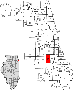
West Englewood | |
---|---|
Community Area 67 - West Englewood | |
Coordinates: 41°46′33″N87°39′51″W / 41.77583°N 87.66417°W | |
Country | United States |
State | Illinois |
County | Cook |
City | Chicago |
Neighborhoods | list
|
Area | |
• Total | 3.15 sq mi (8.16 km2) |
Population (2022) | |
• Total | 25,772 |
• Density | 8,200/sq mi (3,200/km2) |
Demographics 2022 [1] | |
• White | 1.0% |
• Black | 79.6% |
• Hispanic | 17.2% |
• Asian | 0.0% |
• Other | 2.0% |
Time zone | UTC-6 (CST) |
• Summer (DST) | UTC-5 (CDT) |
ZIP Codes | part of 60636 |
Median income 2022 [1] | $29,234 |
Source: U.S. Census, Record Information Services |
West Englewood, one of the 77 community areas, is on the southwest side of Chicago, Illinois. At one time it was known as South Lynne. [2] The boundaries of West Englewood are Garfield Blvd to the north, Racine Ave to the east, the CSX and Norfolk Southern railroad tracks to the west, and the Belt Railway of Chicago to the south. [3] Though it is a separate community area, much of the history and culture of the neighborhood is linked directly to the Englewood neighborhood.
The first European settlers to the area that developed as West Englewood were predominantly German and Swedish farmers who arrived in the 1840s. [4] After construction of rail lines for the Rock Island and Wabash Railroads, the area became known as Chicago Junction, which soon changed to Junction Grove. This is commemorated today with the Junction Grove Playlot Park, which is maintained by the Chicago Park District. [5] By 1865, Junction Grove became the unincorporated town of Lake, which was later renamed Englewood.
Two events led to population increases for the Englewood and West Englewood neighborhoods. In 1871 the Great Chicago Fire destroyed many neighborhoods to the north. The combination of open spaces for housing and the presence of railroad lines made these neighborhoods ideal for Chicagoans looking for less crowding and moving from the urban center destroyed in the fire. In 1889 the neighborhoods of Englewood and West Englewood became part of the City of Chicago after the town of Lake was annexed by the city.
With annexation came Chicago street cars, the second factor to encourage development. In 1903 the Englewood Elevated Railway Company built a branch running roughly along 63rd Street to Loomis, which was connected to the South Side Elevated Railroad. [6] These improvements in transportation made the Englewood area an easy commute for workers traveling north to the stockyards, a major employer, and downtown.
Census | Pop. | Note | %± |
---|---|---|---|
1930 | 63,845 | — | |
1940 | 64,171 | 0.5% | |
1950 | 62,842 | −2.1% | |
1960 | 58,516 | −6.9% | |
1970 | 61,922 | 5.8% | |
1980 | 62,069 | 0.2% | |
1990 | 52,772 | −15.0% | |
2000 | 45,282 | −14.2% | |
2010 | 35,505 | −21.6% | |
2020 | 29,647 | −16.5% | |
[1] [7] |
At the same time that hundreds of thousands of European immigrants were coming to Chicago, where unskilled labor jobs in the stockyards and steel mills enabled them to support families, Blacks from the rural South started migrating to the industrial city. Beginning during World War I, when they replaced workers who were drafted, Blacks migrated to the city in great number before 1940. They were escaping oppressive social and political conditions: lynchings, disfranchisement across the South that prevented them from voting, segregated education in underfunded systems, and legal racial segregation. Initially, they competed with immigrants primarily for unskilled jobs and housing; Blacks were restricted by discrimination in housing practices to narrow areas of older housing on the South Side, known as the Black Belt.
European immigrants and ethnic whites dominated separate territories on the South Side: the Irish, Polish, Italians and others had their own centers of population which they protected against each other and against blacks. According to statistics compiled by the Encyclopedia of Chicago, [8] the West Englewood area had 63,845 residents in 1930, 98% of whom were white and almost 23% foreign born. It reached its peak population in 1940, with more than 64,000 residents.
Industrial restructuring after World War II led to the massive loss of jobs that residents had depended on: the stockyard operations were moved west, first to Kansas City, Kansas, and eventually the good-paying jobs in the steel mills also shifted out of the region. Railroads also restructured, causing more loss of union jobs among both whites and African Americans.
In 1960 the median income was close to the Chicago median income, $6,738 ($69396.09 adjusted for inflation), and 12% of the residents were black. [9]
During the 1960s and after, advances in civil rights opened more areas of housing to blacks, and they followed other Americans into the further reaches of the city, settling in West Englewood and other southern neighborhoods. The changes in industry, however, meant that skilled workers could no longer achieve middle-class lives. Although union jobs were no longer racially restricted, fewer were to be had. Many workers left the area to seek employment, and neighborhoods declined in population and services. Other residents moved further out into suburban towns to seek newer housing.
By 2000 due to the loss of jobs, the population of West Englewood had dropped to 45,282. By that time, with demographic changes, 98% of residents were black. According to the 2000 census, only 1% of the population was foreign born. Late 20th-century immigrants have been primarily from Latin America and Asia, and have created concentrated settlements in other neighborhoods. By the 2020 census, the population had fallen below 30,000, down more than 50% from the peak.
The precipitous population declines in the decades since 1980 led to widespread abandonment of houses and apartment buildings throughout West Englewood. The abandoned structures attracted squatters and criminals, prompting the city government to begin buying up and demolishing vacant structures on a large scale. This program affected many neighborhoods across Chicago, but Englewood and West Englewood, taken together, had by far the highest number of demolitions in the city. [10] Unlike other areas where many abandoned buildings have been demolished by the city, there has been very little interest in redevelopment in West Englewood. Virtually all of the lots cleared in the area remain vacant and the neighborhood's population has continued to rapidly decline.
The headquarters for the Chicago Police Department's 7th district are located in West Englewood. [11]
North Chicago is a city in Lake County, Illinois, United States, and a suburb of the Chicago metropolitan area. The population was 30,759 at the 2020 census making it the third-most populous city by population in the county, after Waukegan and Mundelein.
The Junction is a neighbourhood in Toronto, Ontario, Canada, that is near the West Toronto Diamond, a junction of four railway lines in the area. The neighbourhood was previously an independent city called West Toronto, that was also its own federal electoral district until amalgamating with the city of Toronto in 1909. The main intersection of the area is Dundas Street West and Keele Street. The Stockyards is the northeastern quadrant of the neighbourhood.
Pullman, one of Chicago's 77 defined community areas, is a neighborhood located on the city's South Side. Twelve miles from the Chicago Loop, Pullman is situated adjacent to Lake Calumet.
Norwood Park is one of the 77 Chicago community areas. It encompasses the smaller neighborhoods of Big Oaks, Norwood Park East, Norwood Park West, Old Norwood Park, Oriole Park, and Union Ridge.
Armour Square is a Chicago neighborhood on the city's South Side, as well as a larger, officially defined community area, which also includes Chinatown and the CHA Wentworth Gardens housing project. Armour Square is bordered by Bridgeport to the west, Pilsen to the northwest, Douglas and Grand Boulevard to the east and southeast, and with the Near South Side bordering the area to the north, and Fuller Park bordering its southernmost boundary, along Pershing Road.
North Lawndale is one of the 77 community areas of the city of Chicago, Illinois, located on its West Side. The area contains the K-Town Historic District, the Foundation for Homan Square, the Homan Square interrogation facility, and the greatest concentration of greystones in the city. In 1968, Rev. Dr. Martin Luther King Jr. stayed in an apartment in North Lawndale to highlight the dire conditions in the area and used the experience to pave the way to the Fair Housing Act.
Oakland, located on the South Side of Chicago, Illinois, USA, is one of 77 officially designated Chicago community areas. Bordered by 35th and 43rd Streets, Cottage Grove Avenue and Lake Shore Drive, the Oakland area was developed between 1872 and 1905. Some of Chicago's great old homes may be seen on Drexel Boulevard. The late 19th-century Monument Baptist Church on Oakwood Blvd. is modeled after Boston's Trinity Church. Oakwood/41st Street Beach in Burnham Park is at 4100 S. Lake Shore Drive. With an area of only 0.6 sq mi Oakland is the smallest community area by area in Chicago.
Chatham is one of the 77 community areas of Chicago, Illinois, on the city's South Side. It includes the neighborhoods of Chatham-Avalon, Chatham Club, Chesterfield, East Chatham, West Chatham and the northern portion of West Chesterfield. Its residents are predominantly African American, and it is home to former Senator Roland Burris. Housing many city employees and other officials, Chatham has been a central area for Chicago's middle-class African Americans since the late 1950s.
Roseland is one of the 77 official community areas of Chicago, Illinois, located on the far south side of the city. It includes the neighborhoods of Fernwood, Princeton Park, Lilydale, the southern portion of West Chesterfield, Rosemoor, Sheldon Heights and West Roseland.
Englewood is a neighborhood and community area located on the South Side of Chicago, Illinois, United States. It is also the 68th of the 77 community areas in the city. At its peak population in 1960, over 97,000 people lived in its approximately 3 square miles (7.8 km2), but the neighborhood's population has since dropped dramatically. In 2000, it had a population of approximately 40,000 inhabitants, and the 2010 census indicated that its population has further declined to approximately 30,000. Englewood is bordered by Garfield Boulevard to the north, 75th Street to the south, Racine Avenue to the west, and an irregular border that wends along the Metra Railroad Tracks to the east. On the southwest side of Chicago lies West Englewood, which is generally lumped in with Englewood by Chicagoans. Englewood, a low-income African-American community, has a high rate of foreclosed properties due to its population drop.
Riverdale is one of the 77 official community areas of Chicago, Illinois and is located on the city's far south side.
McKinley Park, one of the 77 official community areas of Chicago, Illinois, is located on the city's southwest side.
New City is one of Chicago's 77 official community areas, located on the southwest side of the city in the South Side district. It contains the neighborhoods of Canaryville and Back of the Yards. The boundaries of New City are Pershing Road to the north, Western Avenue/Boulevard and CSX railroad tracks to the west, Norfolk Southern railroad tracks to the east, and CSX / Orange Line tracks and Garfield Boulevard to the south.
West Elsdon, one of the 77 official community areas, is located on the southwest side of the City of Chicago, Illinois. It is noted as a twin neighborhood of West Lawn. It has a population which includes a mix of dwindling Polish-American residents and increasing Mexican-American residents who currently constitute a clear majority. It has its own association, "West Elsdon Civic Association," which privately organizes the neighborhood. St. Turibius grade school, a Roman Catholic elementary school, located at 57th and Karlov, closed in 2013 and is currently inactive though the building remains and is adjacent to St. Turibius Roman Catholic church. The former Lourdes Roman Catholic girls' high school located from 55th to 56th street from Komensky to Karlov Avenue is now a Chicago Public Schools magnet high school, John Hancock High School.
Chicago Lawn is one of the 77 community areas of Chicago, Illinois. It is located on the southwest side of the city. Its community neighbors include Gage Park, West Englewood, Ashburn, and West Lawn. It is bounded by the CSX and Norfolk Southern Railway tracks on the east, Central Park Avenue on the west, 59th Street on the north, and the Belt Railway of Chicago on the south, and is 13 km (8.1 mi) southwest of the Loop. Local citizens refer to the area as "Marquette Park," after the park in its center.
The history of African Americans in Chicago or Black Chicagoans dates back to Jean Baptiste Point du Sable's trading activities in the 1780s. Du Sable, the city's founder, was Haitian of African and French descent. Fugitive slaves and freedmen established the city's first Black community in the 1840s. By the late 19th century, the first Black person had been elected to office.
The Chicago race riot of 1919 was a violent racial conflict between white Americans and black Americans that began on the South Side of Chicago, Illinois, on July 27 and ended on August 3, 1919. During the riot, 38 people died. Over the week, injuries attributed to the episodic confrontations stood at 537, two-thirds black and one-third white; and between 1,000 and 2,000 residents, most of them black, lost their homes. Due to its sustained violence and widespread economic impact, it is considered the worst of the scores of riots and civil disturbances across the United States during the "Red Summer" of 1919, so named because of its racial and labor violence. It was also one of the worst riots in the history of Illinois.
Frogtown is a neighborhood in Saint Paul in the U.S. state of Minnesota. Built around University Avenue, the Thomas-Dale neighborhood is colloquially known as Frogtown. Historically, Frogtown was a subsection of the current Thomas-Dale neighborhood. It is bordered by University Avenue on the south, the Burlington Northern Railroad tracks to the north, Lexington Parkway on the west and Rice Street on the east.
The Airport Homes race riots were a series of riots in 1946 in the West Lawn and West Elsdon neighborhoods of Chicago, Illinois. It was the worst episode of racial inspired violence that the city faced in some thirty years.
The West Side is one of the three major sections of the city of Chicago, Illinois, United States. It is joined by the North and South Sides. The West Side contains communities that are of historical and cultural importance to the history and development of Chicago. On the flag of Chicago, the West Side is represented by the central white stripe.