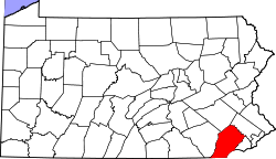
Whitehorse is an unincorporated community in Chester County, in the U.S. state of Pennsylvania. [1]
Chester County (Chesco) is a county in the U.S. state of Pennsylvania. As of the 2010 census, the population was 498,886, increasing by 4.1% to a census-estimated 519,293 residents as of 2017. The county seat is West Chester. Chester County was one of the three original Pennsylvania counties created by William Penn in 1682. It was named for Chester, England.
In the United States, a state is a constituent political entity, of which there are currently 50. Bound together in a political union, each state holds governmental jurisdiction over a separate and defined geographic territory and shares its sovereignty with the federal government. Due to this shared sovereignty, Americans are citizens both of the federal republic and of the state in which they reside. State citizenship and residency are flexible, and no government approval is required to move between states, except for persons restricted by certain types of court orders. Four states use the term commonwealth rather than state in their full official names.
Pennsylvania, officially the Commonwealth of Pennsylvania, is a state located in the northeastern, Great Lakes and Mid-Atlantic regions of the United States. The Appalachian Mountains run through its middle. The Commonwealth is bordered by Delaware to the southeast, Maryland to the south, West Virginia to the southwest, Ohio to the west, Lake Erie and the Canadian province of Ontario to the northwest, New York to the north, and New Jersey to the east.
The community was named after a local inn. [2]
Chester Township is a township in Delaware County, Pennsylvania, United States. The population was 3,940 at the 2010 census, down from 4,604 at the 2000 census.
Delaware County Community College (DCCC) is a two-year community college in the Philadelphia area that serves Delaware and Chester Counties with locations in the Pennsylvania suburbs of Marple Township, Sharon Hill, Upper Darby, Downingtown, Exton, Phoenixville and West Grove.
Brodhead Creek is a 21.9-mile-long (35.2 km) tributary of the Delaware River in the Poconos of eastern Pennsylvania in the United States.
The Great Valley is a west-to-east valley through the center of Chester County, Pennsylvania, United States. It is also sometimes referred to as Chester Valley, and both names are in use throughout the region. The valley stretches from the Schuylkill River in Montgomery County in the east, southwesterly through Chester and Lancaster counties. The valley is most distinct in central Chester County, although traces of it can be followed almost the entire distance between the Delaware and Susquehanna rivers.
Cochranville is a census-designated place (CDP) in West Fallowfield Township, Chester County, Pennsylvania, United States. The population was 668 at the 2010 census. It is the hometown of Olympic swimmer Cierra Runge.
Eagle is an unincorporated community in Upper Uwchlan Township, Chester County, Pennsylvania, United States. Located at 40°4′40″N75°41′16″W, the center of the village is the intersection of Pottstown Pike and Little Conestoga Road, where the historic Eagle Tavern is located. Eagle has recently experienced tremendous development, including upgrades to the village's main roads.
Strasburg Road was an early road in Pennsylvania connecting Philadelphia to Strasburg in Lancaster County. The route was surveyed by John Sellers and others in 1772-3 under the colonial administration of Governor Richard Penn and completed under the new administration of the independent state of Pennsylvania. The route started at the "second ferry" on the Schuylkill River, today's Market Street in Philadelphia, and went through West Chester, East Fallowfield Township, and Gap, before ending in Strasburg. Earlier roads travelled much the same route, including a Native American path in use as early as 1620.
Painters Crossing is a historic area of Chadds Ford Township, Delaware County, Pennsylvania, near where U.S. Route 202 and U.S. Route 1 cross. The area is important in connection to the Revolutionary War battle at Brandywine.
Jennersville is an unincorporated community located in Penn Township, Chester County, Pennsylvania, United States at latitude 39.823 and longitude -75.87. It is associated for postal purposes with the borough of West Grove, Pennsylvania, and appears on the West Grove U.S. Geological Survey Map.
Caln is a census-designated place (CDP) in Caln Township, Chester County, Pennsylvania, United States. The population was 1,519 at the 2010 census. It is located east of the city of Coatesville.
Pomeroy is a census-designated place (CDP) in Sadsbury Township, Chester County, Pennsylvania, United States. The population was 401 at the 2010 census.
Westwood is a census-designated place (CDP) in Valley Township, Chester County, Pennsylvania, United States. The population was 950 at the 2010 census.
Kaolin is an unincorporated community in Chester County in southeastern Pennsylvania in the United States. The community is located on Pennsylvania Route 41 between Avondale to the northwest and Hockessin, Delaware to the southeast.
Faggs Manor is an unincorporated community in Londonderry Township, Chester County, Pennsylvania, in the United States. The hamlet, at the corner of Street Road and Faggs Manor Road includes a church and cemetery with a few nearby houses.
Black Horse is an unincorporated community in Chester County, in the U.S. state of Pennsylvania.
Lincoln University is a census-designated place (CDP) in Lower Oxford Township, Chester County, Pennsylvania. It is located just off campus to Lincoln University about four miles (6.4 km) northeast of the borough of Oxford. The CDP is located near U.S. Route 1. As of the 2010 census, the population was 1,726 residents.
Nantmeal Village is an unincorporated community in Chester County, in the U.S. state of Pennsylvania.
Richville is an unincorporated community in Holt County, in the U.S. state of Missouri.
Schuylkill Friends Meeting House is a Quaker meeting house located on North Whitehorse Road in the Schuylkill Township section of Chester County, Pennsylvania in the United States. This Meeting House is 2.5 miles west of Valley Forge Post Office.
Steelville is an unincorporated community in Chester County, Pennsylvania, United States. According to the 2016 census, the town has not been included in past census counts because the town is so small. It lies next to the Octoraro Creek: the border line between Lancaster County and Chester County.
Coordinates: 39°59′23″N75°28′07″W / 39.98972°N 75.46861°W
A geographic coordinate system is a coordinate system that enables every location on Earth to be specified by a set of numbers, letters or symbols. The coordinates are often chosen such that one of the numbers represents a vertical position and two or three of the numbers represent a horizontal position; alternatively, a geographic position may be expressed in a combined three-dimensional Cartesian vector. A common choice of coordinates is latitude, longitude and elevation. To specify a location on a plane requires a map projection.
This Chester County, Pennsylvania state location article is a stub. You can help Wikipedia by expanding it. |