The Cape Flats is an expansive, low-lying, flat area situated to the southeast of the central business district of Cape Town. The Cape Flats is also the name of an administrative region of the City of Cape Town, which lies within the larger geographical area.
In South Africa, the terms township and location usually refer to the often underdeveloped racially segregated urban areas that, from the late 19th century until the end of apartheid, were reserved for the non-whites, namely Black Africans, Coloureds and Indians. Townships were usually built on the periphery of towns and cities. The term township also has a distinct legal meaning in South Africa's system of land title, which carries no racial connotations.
Alexandra, informally abbreviated to Alex, is a township in the Gauteng province of South Africa. It forms part of the City of Johannesburg Metropolitan Municipality and is located next to the wealthy suburb of Sandton. Alexandra is bounded by Wynberg on the west, Marlboro and Kelvin on the north, Kew, Lombardy West and Lombardy East on the south. Alexandra is one of the poorest urban areas in the country. Alexandra is situated on the banks of the Jukskei River. In addition to its original, reasonably well-built houses, it also has a large number of informal dwellings or "shacks" called imikhukhu.
Swartland Municipality is a local municipality located in the Western Cape province of South Africa. Malmesbury is the seat of the municipality. As of 2016, it had a population of 133,762. Its municipality code is WC015.

Masiphumelele is a township on the Cape Peninsula, South Africa, situated between Kommetjie, Capri Village and Noordhoek.

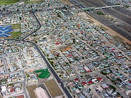
Khayelitsha is a township in Western Cape, South Africa, on the Cape Flats in the City of Cape Town Metropolitan Municipality. The name is Xhosa for New Home. It is reputed to be one of the largest and fastest-growing townships in South Africa.

Langa is a township in Cape Town, South Africa. Its name in Xhosa means "sun". The township was initially built in phases before being formally opened in 1927. It was developed as a result of South Africa's 1923 Urban Areas Act, which was designed to force Africans to move from their homes into segregated locations. Similar to Nyanga, Langa is one of the many areas in South Africa that were designated for Black Africans before the apartheid era. It is the oldest of such suburbs in Cape Town and was the location of much resistance to apartheid.

Wynberg is a southern suburb of the City of Cape Town in Western Cape, South Africa. It is situated between Plumstead and Kenilworth, and is a main transport hub for the Southern Suburbs of Cape Town.

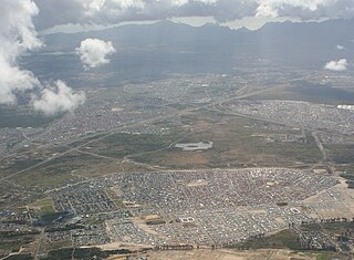
Mitchells Plain is a large township located within the City of Cape Town, Western Cape, South Africa and situated about 28 km (17 mi) from the Cape Town city centre. It is one of South Africa's largest residential areas and contains multiple smaller suburbs. It is located on the Cape Flats on the False Bay coast between Muizenberg and Khayelitsha. Conceived of as a "model suburb" by the apartheid government, it was built during the 1970s to provide housing for Coloured victims of forced removal due to the implementation of the Group Areas Act.

Durbanville, previously called Pampoenkraal, is a town in the Western Cape province of South Africa, part of the greater Cape Town metropolitan area. Durbanville is a semi-rural residential suburb on the north-eastern outskirts of the metropolis surrounded by farms producing wine and wheat.
Mfuleni is a relatively new township about 32 kilometres from central Cape Town, South Africa. It is a predominantly Black township, although there are also some Coloured members of the community.
Lwandle/Nomzamo is a small township in the Helderberg basin just outside Strand in the Western Cape of South Africa. Both names are sometimes used interchangeably referring to both places. This may be attributed to the fact that Nomzamo was born as a result of overpopulation in Lwandle area which initially designed as a cheap accommodation for "single male workers" during the apartheid years.

Crossroads is a high-density township in the Western Cape, South Africa.

Green Point is an affluent suburb on the Atlantic Seaboard of Cape Town, South Africa located to the north west of the central business district. It is home to Cape Town Stadium, a major sporting venue that was built for the 2010 FIFA World Cup. Sea Point promenade runs through the suburb, connecting it to Three Anchor Bay and Sea Point, a popular Jewish neighbourhood. Somerset Road forms the main thoroughfare lined by restaurants, cafés, delis, boutiques and nightclubs.

Delft is a township on the outskirts of Cape Town, South Africa. It is situated next to the Cape Town International Airport, Belhar, Blue Downs, Ikwezi Park, Mandalay, Luzuko, Phillipi East, and Site C, Khayelitsha. It is known for its recreational events, youth empowerment organizations such as Enkosi Foundation and the community has establish a motherbody organisation, the Delft Community Development Forum. Delft is a community that consists of numerous government built housing projects such as the N2 Gateway. In 2022 Delft was the fastest growing community in Cape Town.

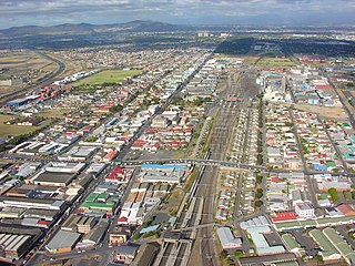
Philippi is a large urban and semi-urban area in Cape Town's Cape Flats region, in the Western Cape, South Africa. It comprises the Philippi Horticultural Area to the west, and the neighbourhoods of Brown's Farm, Philippi East and Samora Machel located within its eastern half. The neighbourhoods of Gugulethu and Nyanga are located to its north. The horticultural area is sparsely populated compared to the surrounding city and contains many farms.

Founded in 2008, the Social Justice Coalition (SJC) is a membership-based social movement made up of 12 branches, located mainly in informal settlements across Khayelitsha, Cape Town. Since its formation, the SJC has worked to advance the constitutional rights to life, dignity, equality, freedom and safety for all people, but especially those living in informal settlements across South Africa. Their campaigns are based on ongoing research, education, and advocacy and divided across two programs. The Local Government Program leads the work on sanitation, budgets, and urban land. The Safety and Justice Program is focused on policing and the criminal justice system.
Maitland is a suburb of Cape Town, South Africa.

Hanover Park is a neighborhood of the City of Cape Town in the Western Cape province of South Africa
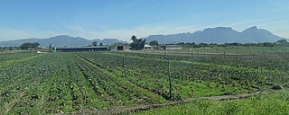
The Philippi Horticultural area is a large semi-rural area of Philippi on the Cape Flats region of Cape Town in the Western Cape province of South Africa. The horticultural area is sparsely populated compared to the surrounding city and contains many farms. The 2011 national census recorded 6,618 residents living in the area with an additional 2,961 residents living in the Knole Park community in the central western part of the area.