Devil's Peak (Cape Town)

Last updated

Devil's Peak
Duiwelspiek
Devils Peak from Lions Head.jpg
Devil's Peak seen from Lion's Head. Hottentots Holland range in the distance
Highest point
Elevation 1,000 m (3,300 ft)
Coordinates 33°57′17.11″S18°26′21.35″E / 33.9547528°S 18.4392639°E / -33.9547528; 18.4392639 (Table Mountain)
Geography
Location Western Cape, South Africa
Geology
Age of rock Silurian/Ordovician
Climbing
Easiest route Hike

Devil's Peak is part of the mountainous backdrop to Cape Town, South Africa. When looking at Table Mountain from the city centre, or when looking towards the city across Table Bay, the skyline from left to right consists of Devil's Peak, the flat summit of Table Mountain, the peak of Lion's Head, and Signal Hill.

Contents

The central districts of Cape Town are located within this natural amphitheatre. The city grew out of a settlement founded on the shore below the mountains in 1652 by Jan van Riebeeck, for the Dutch East India Company. Some of the first farms in the Cape were established on the slopes of Devil's Peak, along the Liesbeek River.

Devil's Peak stands 1,000 metres (3,281 ft) high, less than Table Mountain's 1,087 metres (3,566 ft), and there are a number of hiking routes to the summit.

Landmarks

Devil's Peak with the University of Cape Town's Upper Campus situated on its slopes. UCT Upper Campus landscape view.jpg
Devil's Peak with the University of Cape Town's Upper Campus situated on its slopes.

The Rhodes Memorial to Cecil Rhodes, and the University of Cape Town are situated on the eastern slopes of Devil's Peak. Other landmarks on the eastern slopes are Mostert's Mill, Groote Schuur Hospital, and the Groote Schuur estate, including a number of presidential and ministerial residences.

The King's Blockhouse, situated on Mowbray Ridge Table Mountain-Kings Blockhouse-001.jpg
The King's Blockhouse, situated on Mowbray Ridge

A number of historic military blockhouses are situated on Devil's Peak, along with a number of cannons intended to defend the city from attack from the south. There is an abandoned fire lookout high up on Mowbray Ridge.

Hiking

There are a lot of easy walks on the lower slopes of the mountain. A popular short hike is from Rhodes Memorial to the King's blockhouse. The only generally accessible ascent of the peak is from the Saddle, between the peak and Table Mountain. There are three routes to reach the Saddle: from Tafelberg Road on the city side, up Newlands Ravine from Newlands Forest, or the upper contour path from Mowbray Ridge and Minor Peak. Once on the Saddle, a straightforward path climbs directly to the summit, which has a 360° view of Cape Town and Table Mountain. A number of the gorges on the West side of the mountain are steep, wet and dangerous,particularly Second Waterfall Ravine, Dark Gorge and Els Ravine.

Cape Town from Devil's Peak (DSLR)-1.jpg
A 360° panorama of the Cape Town surrounds as seen from Devil's Peak. Table Mountain is obvious, occupying a large portion of the view. The edges of the panorama point approximately southeast.

Vegetation

Indigenous forest growing on the southern slopes of Devil's Peak 5 Indigenous Afrotemperate Forest on Devils Peak - Cape Town.JPG
Indigenous forest growing on the southern slopes of Devil's Peak

The northern slopes overlooking the city centre are covered in typical Cape Peninsula Shale Fynbos. These slopes are hotter and prone to frequent fires, and as a result the vegetation is low. Here can also be found a small stretch of critically endangered Peninsula Shale Renosterveld vegetation, an endemic vegetation type that used to dominate the Cape Town City Bowl but is now mostly lost due to urban development. [1]

Peninsula Shale Fynbos growing on the northern slopes of Devil's Peak Peninsula Shale Fynbos - DevilsPeak Cape Town.jpg
Peninsula Shale Fynbos growing on the northern slopes of Devil's Peak

The slopes on the Southern Suburbs side however, are naturally wetter and more protected from fires, so these slopes were originally partially covered with deep indigenous forests. Some of these dense afro-montane forests still remain in the gorges, but most of them were cut down to make way for commercial pine plantations. Near Rhodes Memorial there are a stands of the native silver tree, one of the few remaining areas where the tree still grows wild.

During the second half of the 19th century and the first half of the 20th, Devil's Peak (and other adjacent heights) were commercially planted with plantations of cluster pines, a problematic invasive non-indigenous tree. More recently, local authorities and volunteers felled the pines from the higher slopes while maintaining pine and gum plantations in Newlands Forest on the lower reaches of the mountain for recreational purposes. The original indigenous Afro-montane forest is also slowly re-growing on the southern slopes and above Newlands forest where the pines have been cleared, with programmes to remove pines and other alien vegetation continuing. Stone pines (a non-invasive alien tree) still remain in the area around Rhodes Memorial.

Fauna

Tahr herd on Devil's Peak before culling began. Tahr Devils Peak 2004.jpg
Tahr herd on Devil's Peak before culling began.

Indigenous animals include porcupines, caracals, small grey mongoose, rock hyraxes (also known as dassies), and many species of bird. Near Rhodes Memorial, some of the lower slopes of Devil's Peak were artificially maintained as savanna, with eland, wildebeest and zebra kept there, with the zebras forming part of the Quagga Project. These animals were removed from the enclosure in early 2018 due to the uncertain water supply during the Cape Town water crisis.

In the 1930s, a few Himalayan tahrs (wild goats) escaped from a zoo on the slopes of Devil's Peak and bred until their population on the Table Mountain range was over 700. A culling programme has eliminated most of them, although a few still remain. Some of the original local species of small antelope are being re-introduced to replace the tahrs. [2] [3] [4] Fallow deer were once kept in the area of Rhodes Memorial, but were removed starting in 2006. [5]

Geology

Devil's Peak as viewed from the Summit of Table Mountain. Devil's Peak from the Summit of Table Mountain.jpg
Devil's Peak as viewed from the Summit of Table Mountain.

The upper, rocky parts of Devil's Peak, Table Mountain and Lion's Head consist of a hard, uniform and resistant sandstone commonly known as the Table Mountain sandstone or TMS. (This is, however, no longer used as a formal geological name). The tough sandstone rests conformably upon a basal shale that in turn lies unconformably upon a basement of older (Late Precambrian) rocks (Malmesbury shale/slate and the Cape Granite). The basal shale and the older rocks below it weather much faster than the TMS and for this reason the lower slopes are smoother in all parts, with few outcrops and deeper soil. Millions of years of erosion have stripped all of the TMS from Signal Hill and that is why it looks very rounded compared to its sister peaks. There is a road that runs almost on the contour from the lower cable station on Table Mountain along the mountain to Devil's Peak. As it turns east around the bulk of Devil's Peak the road cuttings expose a few famous geological unconformities, which illustrate very clearly that the Malmesbury rocks were folded, baked, intruded by granite and planed down by millions of years of erosion before the area sank below the ocean and a new sequence of sediments, including the TMS, began to accumulate.

Origins of the name

Jan van Hunks smoking with the Devil. G.S. Smithard; J.S. Skelton (1909) - How Table Mountain got its Cloud.jpg
Jan van Hunks smoking with the Devil.

Devil's Peak was originally known as Windberg [6] or Charles Mountain. [7] [8] The English term Devil's Peak is a 19th-century translation from the Dutch Duivels Kop, and supposedly comes from the folk-tale about a Dutch man called Jan van Hunks, a prodigious pipe smoker who lived at the foot of the mountain circa 1700. He was forced by his wife to leave the house whenever he smoked his pipe. One day, while smoking on the slopes of the peak, he met a mysterious stranger who also smoked. They each bragged of how much they smoked and so they fell into a pipe-smoking contest. The stranger turned out to be the devil and Van Hunks eventually won the contest, but not before the smoke that they had made had covered the mountain, forming the table cloth cloud. [9] The story was captured by the 19th century poet Dante Gabriel Rossetti in his poem Jan van Hunks (alternatively called The Dutchman's Wager). [10] However, since Rosetti's poem was only published in 1909, it's unlikely that this was the true source of the name, rather an urban legend.

It has been claimed that the name is a corruption of Duifespiek ("Dove's Peak") to Duivelspiek ("Devil's Peak"), since the Dutch words for devil and dove are relatively close in sound. The Dutch word "Duivelspiek" has been the common Afrikaans language name for the mountain and the suburb on the east side of the city bowl. The name may have been derived from the mountain's 'three pronged' spear shape, which is reminiscent of the spear held by the Devil in many images.[ citation needed ]

Another explanation is provided by Devil's Peak Brewery. [11] Forty years before Vasco de Gama rounded the Cape in 1497, the Venetian cartographer Fra Mauro created a map of the world for King Alfonso V of Portugal, based on knowledge drawn from the Arabians. On this map, which became the definitive view of the world for the early Portuguese explorers, he named the southernmost tip of Africa Cabo de Diab – the Devil's Cape. It is possible the association with the devil migrated from there to the mountain.

1971 plane crash

On 26 May 1971, three South African Air Force Hawker-Siddeley HS125 (Code named Mercurius) aircraft crashed into Devil's Peak, killing all 11 on board. The aircraft were flying in close formation, practicing for a fly-past during the upcoming 10th-anniversary Republic Day celebrations on 31 May. The aircraft, flying by sight along the N2 highway, banked to the right three seconds too late, crashing into the side of the mountain not far above Rhodes Memorial and the University of Cape Town. [12] A low cloud base was cited as a contributory factor. The impact was heard throughout the surrounding suburbs. [13] [14] For many years a radar reflector beacon stood on Plumpudding Hill above Rhodes Memorial to prevent similar incidents.

See also

Related Research Articles

<span class="mw-page-title-main">Table Mountain</span> Flat-topped mountain overlooking the city of Cape Town, South Africa

Table Mountain is a flat-topped mountain forming a prominent landmark overlooking the city of Cape Town in South Africa. It is a significant tourist attraction, with many visitors using the cableway or hiking to the top. Table Mountain National Park is the most visited national park in South Africa, attracting 4.2 million people every year for various activities. The mountain has 8,200 plant species, of which around 80% are fynbos, meaning fine bush. It forms part of the Table Mountain National Park, and part of the lands formerly ranged by Khoe-speaking clans, such as the !Uriǁʼaes. It is home to a large array of mostly endemic fauna and flora.

<span class="mw-page-title-main">Fynbos</span> Shrubland and heathland ecoregion of southwestern South Africa

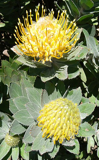
Fynbos is a small belt of natural shrubland or heathland vegetation located in the Western Cape and Eastern Cape provinces of South Africa. This area is predominantly coastal and mountainous, with a Mediterranean climate and rainy winters. The fynbos ecoregion is within the Mediterranean forests, woodlands, and scrub biome. In fields related to biogeography, fynbos is known for its exceptional degree of biodiversity and endemism, consisting of about 80% species of the Cape floral kingdom, where nearly 6,000 of them are endemic. This land continues to face severe human-caused threats, but due to the many economic uses of the fynbos, conservation efforts are being made to help restore it.

<span class="mw-page-title-main">Rondebosch</span> Place in Western Cape, South Africa

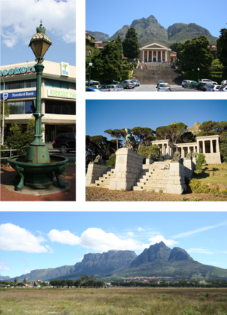
Rondebosch is one of the Southern Suburbs of Cape Town, South Africa. It is primarily a residential suburb, with shopping and business districts as well as the main campus of the University of Cape Town.

<span class="mw-page-title-main">Signal Hill (Cape Town)</span> Hill in Cape Town

Signal Hill, or Lion's Rump, is a landmark flat-topped hill located in Cape Town, next to Lion's Head and Table Mountain.

<span class="mw-page-title-main">Cape Peninsula</span> Rocky peninsula in the Western Cape, South Africa

The Cape Peninsula is a generally mountainous peninsula that juts out into the Atlantic Ocean at the south-western extremity of the African continent. At the southern end of the peninsula are Cape Point and the Cape of Good Hope. On the northern end is Table Mountain, overlooking Table Bay and the City Bowl of Cape Town, South Africa. The peninsula is 52 km long from Mouille point in the north to Cape Point in the south. The Peninsula has been an island on and off for the past 5 million years, as sea levels fell and rose with the ice age and interglacial global warming cycles of, particularly, the Pleistocene. The last time that the Peninsula was an island was about 1.5 million years ago. Soon afterwards it was joined to the mainland by the emergence from the sea of the sandy area now known as the Cape Flats. The towns and villages of the Cape Peninsula and Cape Flats, and the undeveloped land of the rest of the peninsula now form part of the City of Cape Town metropolitan municipality. The Cape Peninsula is bounded to the north by Table Bay, to the west by the open Atlantic Ocean, and to the east by False Bay in the south and the Cape Flats in the north.

<span class="mw-page-title-main">Lion's Head (Cape Town)</span> Mountain in Cape Town, South Africa

Lion's Head is a mountain in Cape Town, South Africa, between Table Mountain and Signal Hill. Lion's Head peaks at 669 metres (2,195 ft) above sea level. The peak forms part of a dramatic backdrop to the city of Cape Town and is part of the Table Mountain National Park.

<span class="mw-page-title-main">Constantiaberg</span> Mountain on the Cape Peninsula, South Africa

Constantiaberg is a large, whale-backed mountain that forms part of the mountainous spine of the Cape Peninsula in Table Mountain National Park, Cape Town, South Africa. It lies about 7 km south of Table Mountain, on the southern side of Constantia Nek. The mountain is 927 m high. It is not known who first ascended the peak.

<span class="mw-page-title-main">Table Mountain National Park</span> A nature conservation area on the Cape Peninsula in Cape Town, South Africa

Table Mountain National Park, previously known as the Cape Peninsula National Park, is a national park in Cape Town, South Africa, proclaimed on 29 May 1998, for the purpose of protecting the natural environment of the Table Mountain Chain, and in particular the rare fynbos vegetation. The park is managed by South African National Parks. The property is included as part of the UNESCO Cape Floral Region World Heritage Site.

<i>Leucadendron argenteum</i> Species of tree

Leucadendron argenteum is an endangered plant species in the family Proteaceae, which is endemic to a small area of the Cape Peninsula, South Africa. Most grow in and around the city of Cape Town, but outlying populations exist near Somerset West (Silwerboomkloof), Paarl and Stellenbosch. It is a protected tree in South Africa.

<span class="mw-page-title-main">Rhodes Memorial</span> Memorial to British born, South African politician Cecil John Rhodes

The Rhodes Memorial is a monument on Devil's Peak in Cape Town, South Africa, a memorial to the English-born South African politician Cecil John Rhodes. It was designed by architect Herbert Baker.

<span class="mw-page-title-main">Southern Suburbs, Cape Town</span> Sub-region of Cape Town, South Africa

The Southern Suburbs are a group of Anglophone suburbs in Cape Town, Western Cape, South Africa. This group includes, among others, Observatory, Mowbray, Pinelands, Rosebank, Rondebosch, Rondebosch East, Newlands, Claremont, Lansdowne, Kenilworth, Bishopscourt, Constantia, Wynberg, Ottery, Plumstead, Diep River, Bergvliet and Tokai. The area is also commonly referred to as the Cape Peninsula, often including the towns further South such as Fish Hoek.

<span class="mw-page-title-main">Newlands Forest</span> Conservancy area in Cape Town, South Africa

Newlands Forest is a conservancy area on the eastern slopes of Table Mountain, beside the suburb of Newlands, Cape Town, South Africa. It is owned and maintained by the Table Mountain National Parks Board, along with the City Parks Department of Cape Town, and includes a Fire Station, Nursery and Reservoir.

<span class="mw-page-title-main">2009 Table Mountain fire</span> Large fire in and around the Table Mountain National Park in Cape Town, South Africa

The 2009Table Mountain fire was a large fire in and around the Table Mountain National Park in Cape Town, South Africa. It broke out at approximately 20:30 on 17 March 2009 in the vicinity of Rhodes Memorial and initial fears were that the fire would spread to UCT's Upper Campus. The Table Mountain National Park quickly deployed firefighting personnel on the mountain, but the fire spread due to the strong winds. At around 23:20 on Tuesday evening, the fire started moving up Devil's Peak and by 00:00 was at the tip and making its way around the mountain to the suburbs of Tamboerskloof, Oranjezicht, Vredehoek and Gardens on the north side. The flames were engulfing the mountain and the huge amounts of smoke made it hard for rescue and fire-fighting helicopters making their way to the fire. By 00:30, people from the aforementioned areas were told to evacuate due to the strong winds pushing the fire around the mountain. By this time, Fire & Rescue Services had deployed 29 fire engines and 90 firefighters who were assisted by 45 firefighters from the South African National Parks and volunteers of Disaster Management

<span class="mw-page-title-main">Peninsula Granite Fynbos</span> Vegetation type endemic to the city of Cape Town, South Africa

Peninsula Granite Fynbos is an endangered Fynbos vegetation type which is endemic to the city of Cape Town and occurs nowhere else. It is a unique type of tall, dense and diverse scrubland, scattered with trees. It can be found all along the belt of granite that encircles Table Mountain.

<span class="mw-page-title-main">Peninsula Shale Renosterveld</span> Vegetation type found only in South Africa

Peninsula Shale Renosterveld (PSR) is a unique vegetation type that is found only on the slopes of Signal Hill and Devil's Peak in Cape Town, South Africa. It is critically endangered and exists nowhere else.

<span class="mw-page-title-main">Cape Winelands Shale Fynbos</span> Vegetation type endemic to the Boland of the Western Cape, South Africa.

Cape Winelands Shale Fynbos is a vegetation type that naturally occurs in the Cape Winelands of the Western Cape, South Africa.

Blaauwberg Nature Reserve was proclaimed a local and provincial nature reserve in 2007. The reserve has views down fynbos slopes, across the city, to seven kilometres of rocky and sandy coastline and the ocean and beyond. The reserve presents itself as one of the few viewpoints in the world from where you can see two proclaimed world heritage sites, namely Table Mountain and Robben Island.

<span class="mw-page-title-main">Cecilia, Table Mountain</span> Section of the Table Mountain National Park

Cecilia is a section of the Table Mountain National Park on the lower eastern slopes of Table Mountain in Cape Town, located just to the south of Kirstenbosch National Botanical Garden. It was previously used for commercial logging and known as Cecilia Forest or Cecilia Plantation, but has now been given protected status and integrated into the National Park.

<span class="mw-page-title-main">Devil's Peak Estate</span> Suburb of Cape Town, in Western Cape, South Africa

Devil's Peak Estate is a suburb of Cape Town, South Africa in the area known as the City Bowl. It is sandwiched between Vredehoek and Zonnebloem on the slopes of Devil's Peak. According to the 2011 census it has a population of 1,859 residents in an area of 0.46 square kilometres (0.18 sq mi).

<span class="mw-page-title-main">2021 Table Mountain fire</span> Cape Town fire that destroyed historic mill and library collections

The 2021 Table Mountain fire is a major fire that started on 18 April 2021 in and around Table Mountain National Park and the neighbourhoods of Newlands, Rosebank, Mowbray and Rondebosch in Cape Town, South Africa. The damage to sites in the Table Mountain area included the Rhodes Memorial, where a restaurant burned down; the upper campus of the University of Cape Town (UCT), where the Special Collections library was gutted; and Mostert's Mill, a historic windmill that burned down. In addition, five firefighters were hospitalised.

References

  1. "Peninsula Shale Renosterveld. Cape Town Biodiversity Factsheets" (PDF).[ permanent dead link ]
  2. Watkins, Karin (2003). Adventure Walks and Scrambles in the Cape Peninsula. p. 16. ISBN   1-919930-26-4.
  3. "About 100 tahrs now on Table Mountain". Pretoria News . 28 February 2003. Retrieved 27 July 2010.
  4. "'Humane' guns claim 95% of tahrs". Cape Times . 10 July 2004. Retrieved 27 July 2010.
  5. "Devil's Peak deer set for capture". IOL. 19 July 2006. Retrieved 16 October 2023.
  6. Pettman, Charles (1913). Africanderisms; a glossary of South African colloquial words and phrases and of place and other names. Longmans, Green and Co. p. 143.
  7. Pettman, Charles (1913). Africanderisms; a glossary of South African colloquial words and phrases and of place and other names. Longmans, Green and Co. p. 143.
  8. Phillip, Authur (2006). The Voyage Of Governor Phillip To Botany Bay. Echo Library. p. 39. ISBN   1-4068-3096-8.
  9. Van Lill, Dawid (2004). Van Lill se Suid-Afrikaanse trivia. p. 14. ISBN   1-86872-927-3.
  10. "Jan van Hunks". Rossetti Archive. Retrieved 27 July 2010.
  11. "How Devil's Peak Really Got Its Name | Craft beer from Cape Town, South Africa | Devil's Peak Brewing Company". Archived from the original on 6 December 2014. Retrieved 8 December 2014.
  12. Ranter, Harro. "ASN Aircraft accident Hawker Siddeley HS-125-400B 02 Devil's Peak". aviation-safety.net. Retrieved 12 April 2018.
  13. Byrom, James (1993). Fields of Air. Ashanti Publishing. ISBN   1-919874-12-7.
  14. "Tragedy on Devils Peak and the end of the SAAF H.S. 125 Mercurius fleet". The Observation Post. 26 October 2015.