
Aldergrove is a townland sub-division in County Antrim, Northern Ireland. It is within the townland of Seacash and parish of Killead – 6 miles (9.7 km) south of Antrim and 18 miles (29 km) west of Belfast. It is part of the Borough of Antrim and Newtownabbey.
Donegore is the name of a hill, a townland, a small cluster of residences, and a civil parish in the historic barony of Antrim Upper, County Antrim, Northern Ireland. Donegore lies approximately 5 miles (8 km) east of Antrim town. 154 acres of the townland lies in the civil parish of Grange of Nilteen.
Lisnagarvey or Lisnagarvy is a townland in County Antrim, Northern Ireland. Lisnagarvey is also the original name of Lisburn.

Ballygalley or Ballygally is a village and holiday resort in County Antrim, Northern Ireland which lies on the Antrim coast, approximately 3 miles north of Larne. It is also a townland of 769 acres and is situated in the civil parish of Carncastle and the historic barony of Glenarm Upper. It had a population of 821 in the 2011 Census. It is located within the Mid and East Antrim Borough Council area.
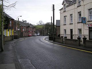
Cullybackey or Cullybacky is a village in County Antrim, Northern Ireland. It lies 3 miles north-west of Ballymena, on the banks of the River Main, and is part of Mid and East Antrim district. It is a predominantly Protestant area. It had a population of 2,569 people in the 2011 Census.

Ballystrudder or Ballystruder is a small village and townland on Islandmagee in County Antrim, Northern Ireland. It is situated in the historic barony of Belfast Lower and the civil parish of Islandmagee. It is part of Mid and East Antrim Borough Council. It had a population of 992 people in the 2011 Census.
Balnamore is a small village in County Antrim, Northern Ireland. It is within the townland of Ballynacree-Skein and lies 3 km west of Ballymoney. It is part Causeway Coast and Glens District Council. Historically it was known as Balnamore.

Drumbeg is a small village, townland and civil parish on the south bank of the River Lagan in County Down, Northern Ireland. The village is covered by the Lisburn City Council area and forms part of the suburban fringe of Belfast.
Lambeg is a small village and civil parish in County Antrim, Northern Ireland. Located between Belfast and Lisburn, it was once a small rural village, but is now within the Greater Belfast conurbation. Lambeg is also an electoral ward of Lisburn Council. In the 2001 Census it had a population of 60 people. The civil parish of Lambeg covers areas of County Down as well as County Antrim.
Barmeen is a townland in County Antrim, Northern Ireland. It is located at the foot of Glendun, one of the nine Glens of Antrim, west of Cushendun and north of Knocknacarry. It is situated in the historic barony of Cary and the civil parish of Culfeightrin and covers 59 acres.
Knocknacarry is a hamlet and townland about 1 kilometre west of Cushendun in County Antrim, Northern Ireland. It is situated in the historic barony of Glenarm Lower and the civil parish of Layd. In the 2001 Census it had a population of 138 people. It is within the Moyle District Council area.
Cargan is a small village and townland in County Antrim, Northern Ireland. It lies at the foot of Slievenanee in Glenravel – locally known as "The Tenth Glen" along with the more widely known nine Glens of Antrim. It is part of Mid and East Antrim district. It had a population of 588 people in the 2011 Census.
Groggan is a hamlet and townland near Randalstown in County Antrim, Northern Ireland. It is situated in the historic barony of Toome Upper and the civil parish of Drummaul and covers an area of 620 acres. It is within the Borough of Antrim. It had a population of 135 people in the 2011 Census.
Bendooragh is a small village and townland in County Antrim, Northern Ireland, 2 1⁄2 miles (4.0 km) south west of Ballymoney. It is part of Causeway Coast and Glens District Council. It had a population of 622 people in the 2011 Census.
Ballyvoy is a small village and townland in County Antrim, Northern Ireland. It is on the main A2 coast road 5 km east of Ballycastle and 17 km north west of Cushendall. In the 2001 Census it had a population of 72 people. It lies within the Antrim Coast and Glens Area of Outstanding Natural Beauty and is part of Causeway Coast and Glens District Council.

Moss-side or Mosside is a small village and townland in County Antrim, Northern Ireland. In the 2001 Census it had a population of 270 people.

Tievebulliagh is a 402-metre-high (1,319 ft) mountain in the Glens of Antrim, Northern Ireland. It forms part of the watershed between Glenaan to the north and Glenballyemon to the south. It is situated about 4.4 km from Cushendall.
Capecastle or Cape Castle is a small village and townland in County Antrim, Northern Ireland, between Armoy and Ballycastle. It is part of the Causeway Coast and Glens district.

Carrickfergus is a barony in County Antrim, Northern Ireland. It is bounded on the south-east by Belfast Lough, and otherwise surrounded by the barony of Belfast Lower. It is coextensive with the civil parish of Carrickfergus or St Nicholas and corresponds to the former county of the town of Carrickfergus, a county corporate encompassing Carrickfergus town.

Derrykeighan is a hamlet, civil parish and townland in County Antrim, Northern Ireland, 4 miles (7.5 km) north of Ballymoney. It is situated in the historic barony of Dunluce Lower.

