Mount Clemenceau is the fourth highest mountain in the Park Ranges of the Canadian Rockies. The peak was originally named "Pyramid" in 1892 by Arthur Coleman. The mountain was renamed by the Interprovincial Boundary Survey in 1919 to its present name, which is for Georges Clemenceau, premier of France during World War I.

Mount Bryce is a mountain at the southwestern corner of the Columbia Icefield, in British Columbia, Canada, near the border with Alberta. It can be seen from the Icefields Parkway.

The Ball Range is a mountain range on the Continental Divide between Vermilion Pass and Red Earth Pass in Kootenay National Park, Canada. The range is named after John Ball, a politician who helped secure funding for the Palliser expedition.

Mount Brazeau is a mountain in Alberta, Canada.

The Bare Range is a mountain range of the Canadian Rockies, located south of the Red Deer River valley in Banff National Park, Canada. The range is named for the "bareness" of or lack of trees on the gentle slopes of the range.

The Blue Range is a mountain range of the Canadian Rockies, located on the Continental Divide in Banff National Park, Canada. The range was so named on account of its blueish colour when viewed from afar. Mount Alcantara is the highest point in the range.

Heart Mountain is a mountain located in the Bow River valley just south of Exshaw, Alberta. The peak was named in 1957 for the heart shaped layer of limestone near the top.

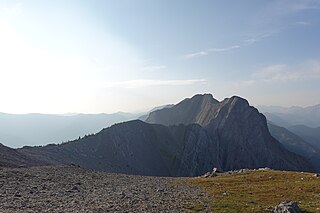
Pyramid Mountain is a mountain in Jasper National Park, Alberta, Canada, named for its pyramid-like shape. James Hector named the mountain in 1859 due to its appearance from the Athabasca River valley on the eastern side of the peak.

The Beaverfoot Range is a mountain range in the Kootenay Ranges of the Canadian Rockies, located in southeastern British Columbia. The range extends from Cedared Creek near Spillimacheen north to the Kicking Horse River.

The Palliser Range is a mountain range of the Canadian Rockies that lies in the extreme southeast corner of Banff National Park, Alberta, Canada.

Monarch Mountain is one of the principal summits of the Pacific Ranges subdivision of the Coast Mountains in southern British Columbia. It stands just east of a pass between the Klinaklini River and the south branch of the Atnarko River, which is a tributary of the Bella Coola River. Surrounding Monarch Mountain is the Monarch Icefield, the northernmost of the major icefields of the Pacific Ranges, and just south of it is the Ha-Iltzuk Icefield, which is the largest. Monarch is in the southern end of Tweedsmuir South Provincial Park.

The Massive Range is a mountain range of the Canadian Rockies, located in the southwestern area of the Bow River valley in Banff National Park, Canada.

Castle Mountain is a ski resort located in the Westcastle Valley of southwest Alberta, Canada in the Rocky Mountains. It is approximately 260 kilometres (160 mi) from Calgary and the Calgary International Airport; 140 kilometres (87 mi) from Lethbridge; and 50 kilometres (31 mi) west of Pincher Creek. The resort is renowned for long steep runs and an average 8.5 metres (28 ft) of snowfall yearly.
The Fiddle Range is a mountain range of the Canadian Rockies located south of Highway 16 on the east border of Jasper National Park, Canada.
Powder Mountain, 2,347 m (7,700 ft), is a volcanic summit in the Powder Mountain Icefield in the Pacific Ranges of the Coast Mountains in southwestern British Columbia, Canada.

The Spearhead is a 2,457 m (8,061 ft) peak in the Garibaldi Ranges of British Columbia, Canada, and is one of the main summits of the Blackcomb Mountain portion of the Whistler Blackcomb ski resort, located at the apex of the Blackcomb and Spearhead Glaciers, which is named for it. It also is the namesake of the Spearhead Range, which is the short range flanking the north side of Fitzsimmons Creek and ending on its northwest end at Blackcomb Mountain. The mountain's name was officially adopted on August 27, 1965, by the Geographical Names Board of Canada.

Asperity Mountain is a mountain located in British Columbia, Canada, rising to 3,716 metres (12,192 ft). It is located between Tellot and Tiedemann Glaciers on the north and south respectively, in the Waddington Range, a subrange of the Pacific Ranges. The gorge of the Homathko River runs north to south on the east side of the mountain, carrying runoff from the mountain and glaciers to the Pacific Ocean.
Fortress Pass is a mountain pass that crosses the continental divide in the Canadian Rockies, south of Jasper, Alberta. At 1,335 metres (4,380 ft), Fortress Pass is one of the lowest passes to cross the Canadian Rockies that is not traversed by a road. In addition to being at a low elevation, Fortress Pass is also relatively gentle, with almost no elevation difference between water bodies on either side.
Mount Ulysses, is the highest mountain in the Muskwa Ranges of the Northern Canadian Rockies in British Columbia. It and neighbouring peaks are part of a group of names drawing on the epic poem The Odyssey, in which here Ulysses wanders for 10 years before being able to return home to Ithaca.
ʔEniyud, also known as Niut Mountain, is one summits of the Chilcotin Ranges subdivision of the Pacific Ranges of the Coast Mountains of southern British Columbia. Standing West of Telhiqox Biny, it is 2,877 m (9,439 ft) in elevation.
