
Los Gatos is an incorporated town in Santa Clara County, California, United States. The population is 30,222 according to the 2019 United States Census Bureau. It is located in the San Francisco Bay Area just southwest of San Jose in the foothills of the Santa Cruz Mountains. Los Gatos is part of Silicon Valley, with several high technology companies maintaining a presence there. Notably, Netflix, the streaming service and content creator, is headquartered in Los Gatos and has developed a large presence in the area.

The Santa Cruz Mountains, part of the Pacific Coast Ranges, are a mountain range in central and northern California, United States. They form a ridge down the San Francisco Peninsula, south of San Francisco. They separate the Pacific Ocean from the San Francisco Bay and the Santa Clara Valley, and continue south to the Central Coast, bordering Monterey Bay and ending at the Salinas Valley. The range passes through the counties of San Mateo, Santa Clara, Santa Cruz, San Benito and Monterey, with the Pajaro River forming the southern boundary.
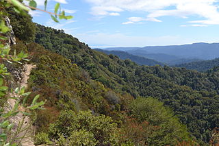
Castle Rock State Park is a 5,242-acre (2,121 ha) state park of California, United States, located along the crest of the Santa Cruz Mountains and almost entirely in Santa Cruz County, with parts extending into Santa Clara County and San Mateo County. It embraces coast redwood, Douglas fir, and madrone forest, most of which has been left in its wild, natural state. Steep canyons are sprinkled with unusual rock formations that are a popular rock climbing area. The park is named after a sandstone formation called Castle Rock. The forest here is lush and mossy, crisscrossed by 32 miles (51

State Route 9 is a rural and mountainous state highway in the U.S. state of California that travels 35 miles (56 km) from SR 1 in Santa Cruz to SR 17 in Los Gatos, passing through the San Lorenzo Valley and the Saratoga Gap in the Santa Cruz Mountains.
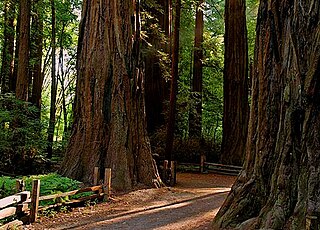
Henry Cowell Redwoods State Park is a state park of California, United States, preserving mainly forest and riparian areas in the watershed of the San Lorenzo River, including a grove of old-growth coast redwood. It is located in Santa Cruz County, primarily in the area between the cities of Santa Cruz and Scotts Valley, near the community of Felton and the University of California at Santa Cruz. The park includes a non-contiguous extension in the Fall Creek area north of Felton. The 4,623-acre (1,871 ha) park was established in 1954.

Uvas Canyon County Park is a 1,147-acre (464 ha) natural park located in upper Uvas Canyon on the eastern side of the Santa Cruz Mountains, west of Morgan Hill, California. The park has several small waterfalls, some of which flow perennially, that feed into tributaries confluent with Uvas Creek. The park is part of the Santa Clara County Parks System, and facilitates picnics, hiking and overnight camping. It is one of the few parks in the area that allows dogs in the campgrounds.

Vasona Lake County Park is a park located in Los Gatos, California and part of the Santa Clara County Parks system.
Area codes 408 and 669 are telephone area codes in the North American Numbering Plan (NANP) in the U.S. state of California. The numbering plan area comprises most of Santa Clara County and Northern Santa Cruz County, and includes Gilroy, Morgan Hill, Saratoga, Los Gatos, Monte Sereno, Milpitas, Sunnyvale, Santa Clara, Cupertino, Campbell, and San Jose.

Redwood Estates is a rural unincorporated community along State Route 17 in the coastal Santa Cruz Mountains in Los Gatos, California, United States. The Census Bureau includes it in a census-designated place named Lexington Hills. It lies inside the confines of Santa Clara County. The area is about eight miles from downtown Los Gatos and nine miles from the Santa Cruz County community of Scotts Valley.

Sanborn County Park is a 3,453 acres (13.97 km2) public park situated in the Santa Cruz Mountains owned by the county of Santa Clara, California, adjacent to Castle Rock State Park and the Los Altos Rod and Gun Club Range and Santa Clara County Peace Officers Association gun range. The park is managed by the Santa Clara County Parks and Recreation Department. The park is heavily forested and offers hiking and other generally low intensity outdoor uses. The park lies between the town of Saratoga and the ridgetop road, Skyline Boulevard. In the summer months, Sanborn County Park hosts the only outdoor Shakespearean company in Silicon Valley.

The Los Gatos Creek runs 24 miles (39 km) in California through Santa Clara Valley Water District's Guadalupe Watershed from the Santa Cruz Mountains northward through the Santa Clara Valley until its confluence with the Guadalupe River in downtown San Jose. The Guadalupe River then continues onward into San Francisco Bay.

Lexington Reservoir is an artificial lake on the Los Gatos Creek near Los Gatos, California. The James J. Lenihan Dam, a 195 ft (59 m) high, 1,000 ft (300 m) thick earthen dam, forms the third-largest reservoir in Santa Clara County.
Summit is a small unincorporated community more frequently referred to by locals as the Loma Prieta Community located partially in Santa Clara County but predominantly in Santa Cruz County, California, in the mountain ranges of the Santa Cruz Mountains. It lies at the summit along Highway 17 from which is gets its name. Home to a series of abandoned railroad towns and tunnels from a Los Gatos to Felton route before the 1940s, Public transportation by bus is also no longer available from the Summit Road area. VTA route 76 has been cancelled since June 2010, and the Highway 17 Express only stops in Scotts Valley. It is one of the few places in the San Francisco Bay Area to receive snowfall and the mountain pass which links the Silicon Valley and Monterey Bay is closed at this spot when snowfall is too heavy. The next town to the south is Scotts Valley and to the north Redwood Estates. The area serves as a rest stop with food for people traveling across the mountains. It straddles the county line with Santa Clara County and is south of the unincorporated area of Lexington Hills with which it shares a zip code. The ZIP Code is 95033 and the community is inside area code 408.

Wrights, California is a ghost town in unincorporated west Santa Clara County, California. It is located near Summit Road in the Santa Cruz Mountains, on the north bank of Los Gatos Creek, east of State Route 17.

Alma is a ghost town and drowned town in Santa Clara County in California, United States. It lies beneath the waters of the Lexington Reservoir above Los Gatos. The location is latitude 37.18N and longitude 121.98W. It was 551 feet above sea level.

Patchen is a ghost town nestled in the Santa Cruz Mountains, in unincorporated west Santa Clara County, California. It is located along the Old Santa Cruz Highway, east of State Route 17.

Sierra Azul Open Space Preserve is managed by the Midpeninsula Regional Open Space District in Santa Clara County, California. It is approximately 17,000 acres (6,900 ha) in area. The preserve is named for the Sierra Azul or "Blue Mountains", the name the colonizing Spanish used for the half of the Santa Cruz Mountains south of today's California Highway 17.

Lexington Hills is an unincorporated census county division (CCD) located on the eastern side of the Santa Cruz Mountains in west Santa Clara County, California. The area covers approximately 54 square miles (140 km2), much of it open space, and contains Lake Elsman, Lexington, and Williams reservoirs, as well as the Lexington Reservoir County Park and Bear Creek Redwoods and Sierra Azul open space preserves. The Lexington Hills communities, as well as the former Almaden Air Force Station on Mount Umunhum, and Loma Prieta are also located in the area.
The Bear Creek Redwoods Open Space Preserve is a public open space preserve in the Santa Cruz Mountains. The preserve is located along both sides of Bear Creek Road, west of State Route 17 and Lexington Reservoir, and mostly north and east of the Skyline Boulevard and Summit Road sections of State Route 35. It surrounds the Presentation Center, a conference and retreat facility run by the Sisters of Presentation.

